Eno River
The Eno River, named for the Eno Indians who once lived along its banks, is the initial tributary of the Neuse River in North Carolina, USA.
| Eno River | |
|---|---|
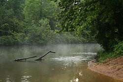 The Eno River near Falls Lake | |
 Location of Eno River mouth | |
| Location | |
| Country | United States |
| State | North Carolina |
| Counties | Orange Durham |
| Cities | Hillsborough, Durham |
| Physical characteristics | |
| Source | Confluence of East and West Forks of Eno River |
| • location | about 5 miles north of Efland, North Carolina |
| • coordinates | 36°07′42″N 079°09′29″W[1] |
| • elevation | 568 ft (173 m)[2] |
| Mouth | Neuse River at Falls Lake |
• location | Durham, North Carolina, NC |
• coordinates | 36°05′42″N 078°48′48″W[1] |
• elevation | 252 ft (77 m) |
| Length | 40 mi (64 km) |
| Basin size | 259.74 square miles (672.7 km2) |
| Discharge | |
| • location | Neuse River at Falls Lake |
| • average | 252.08 cu ft/s (7.138 m3/s) at mouth with Neuse River at Falls Lake[3] |
| Basin features | |
| Progression | generally east |
| River system | Neuse River |
| Tributaries | |
| • left | Dry Run Strouds Creek Little Creek Buckwater Creek Crooked Creek Little River Flat River |
| • right | McGowan Creek Sevenmile Creek Cates Creek Stony Creek Rhodes Creek |
| Waterbodies | Falls Lake |
The Eno rises in Orange County. The river's watershed occupies most of Orange and Durham counties. The Eno converges with the Flat and Little Rivers to form the Neuse at Falls Lake, which straddles Durham and Wake counties.
The Eno is notable for its beauty and water quality, which has been preserved through aggressive citizen efforts. Though barely more than forty miles from its source to its convergence at the Neuse, the Eno features significant stretches of natural preservation. Through the combined efforts of the North Carolina State Parks System, local government, and private non-profit preservation groups, over 5,600 acres (23 km2) of land have been protected in the Eno Basin, including Occoneechee Mountain State Natural Area, Eno River State Park, West Point on the Eno (a Durham City Park), and Penny's Bend State Nature Preserve (managed by the North Carolina Botanical Garden).
Permitted recreational activities include swimming, hiking, fishing, canoeing, kayaking, and backcountry camping. Individual and group campsites are available.[4]
See also
| Wikimedia Commons has media related to Eno River. |
- List of North Carolina rivers
- Eno River State Park
- West Point on the Eno
References
- "GNIS Detail - Eno River". geonames.usgs.gov. Us Geological Survey. Retrieved 21 July 2019.
- "Eno River Topo Map, Durham County NC (Northeast Durham Area)". TopoZone. Locality, LLC. Retrieved 21 July 2019.
- "Eno River Watershed Report". Waters Geoviewer. US EPA. Retrieved 21 July 2019.
- "Eno River State Park | NC State Parks". www.ncparks.gov. Retrieved 2018-02-12.
External links
- Eno River Association
- Eno River State Park
- Occoneechee Mountain State Natural Area
- Penny's Bend State Nature Preserve
- West Point on the Eno - Durham City Park