Franklin County, North Carolina
Franklin County is a county located in the U.S. state of North Carolina. As of the 2010 census, the population was 60,619.[1] Its county seat is Louisburg.[2]
Franklin County | |
|---|---|
.jpg) Franklin County Courthouse in Louisburg. July 1948. | |
 Seal | |
| Motto(s): LEGES JURAQUE VINDICAMUS "We Defend Laws and Justice" | |
 Location within the U.S. state of North Carolina | |
 North Carolina's location within the U.S. | |
| Coordinates: 36°05′N 78°17′W | |
| Country | |
| State | |
| Founded | 1779 |
| Named for | Benjamin Franklin |
| Seat | Louisburg |
| Largest town | Louisburg |
| Area | |
| • Total | 494 sq mi (1,280 km2) |
| • Land | 492 sq mi (1,270 km2) |
| • Water | 2.8 sq mi (7 km2) 0.6%% |
| Population | |
| • Estimate (2018) | 67,560 |
| • Density | 123/sq mi (47/km2) |
| Time zone | UTC−5 (Eastern) |
| • Summer (DST) | UTC−4 (EDT) |
| Congressional district | 2nd |
| Website | www |
Franklin County is included in the Raleigh, NC Metropolitan Statistical Area, which is also included in the Raleigh-Durham-Chapel Hill, NC Combined Statistical Area, which had a 2012 estimated population of 1,998,808.[3]
History
The county was formed in 1779 from the southern half of Bute County. It is named for Benjamin Franklin.[4] It is a part of the Research Triangle.
County formation timeline
- 1664 Albemarle County formed (original, extinct)
- 1668 Albemarle County subdivided into Carteret, Berkeley, & Shaftesbury Precincts
- 1681 Shaftesbury Precinct renamed Chowan Precinct
- 1722 Bertie Precinct formed from Chowan Precinct
- 1739 Bertie Precinct becomes Bertie County
- 1741 Edgecombe County formed from Bertie County
- 1746 Granville County formed from Edgecombe County
- 1754 Creation of Bertie Precinct, Edgecombe County, & Granville County repealed by King George II, in Privy Council
- 1756 Bertie, Edgecombe, & Granville re-created
- 1764 Bute County (extinct) formed from Granville County
- 1779 Franklin County formed from Bute County (extinct)
- 1787 Franklin County gains land from Wake County
- 1875 Franklin County gains land from Granville County
- 1881 Franklin County loses land to help form Vance County
Monument to racial segregation
Louisburg contains a unique monument to racial segregation, in front of the Courthouse, where a Confederate flag separates two drinking fountain, one labeled (in the granite) "white" and the other "colored".
School desegregation
The integration of Franklin County Schools in 1965–1968 was marked by a federal lawsuit and some violence against African-American residents. The North Carolina Humanities Council funded the Tar River Center for History and Culture at Louisburg College to prepare "An Oral History of School Desegregation in Franklin County, North Carolina."[5][6]
County song
The "Franklin County Song" was selected in a 1929 contest by the county historical association as the song most suitable for public occasions. The words were written by Fred U. Wolfe, an agriculture teacher at Gold Sand. Sung to the tune "Maryland, My Maryland" ("O Christmas Tree"), the song was incorporated in the Bicentennial programs of 1979. At the evening convocation of January 29, Mrs. Beth Norris announced to the audience that Wolfe (retired and residing in North, South Carolina) was aware his song was part of the program that night. (See Franklin Times, January 30, 1979.)[7]
With loyalty we sing thy praise,
Glory to thy honored name!
Our voices loud in tribute raise,
Making truth thy pow'r proclaim.
Thy past is marked with vict'ry bold;
Thy deeds today can ne'er be told,
And heroes brave shall e'er uphold
Franklin's name forevermore.
We love thy rich and fruitful soil,
Wood, and stream, and thriving town.
We love the gift of daily toil,
Making men of true renown.
Thy church and school shall ever stand
To drive the darkness from our land—
A true and loyal, valiant band,
Sons of Franklin evermore.
A shrine of promise, pow'r and truth,
Lasting righteousness and peace,
A land of hope for toiling youth,
Yielding songs that never cease.
Let ev'ry son and daughter stay
The hand of vice that brings decay.
When duty's voice we shall obey,
Franklin's name shall live for aye.
Geography
According to the U.S. Census Bureau, the county has a total area of 494 square miles (1,280 km2), of which 492 square miles (1,270 km2) is land and 2.8 square miles (7.3 km2) (0.6%) is water.[8]
Demographics
| Historical population | |||
|---|---|---|---|
| Census | Pop. | %± | |
| 1790 | 7,502 | — | |
| 1800 | 8,529 | 13.7% | |
| 1810 | 10,166 | 19.2% | |
| 1820 | 9,741 | −4.2% | |
| 1830 | 10,665 | 9.5% | |
| 1840 | 10,980 | 3.0% | |
| 1850 | 11,713 | 6.7% | |
| 1860 | 14,107 | 20.4% | |
| 1870 | 14,134 | 0.2% | |
| 1880 | 20,829 | 47.4% | |
| 1890 | 21,090 | 1.3% | |
| 1900 | 25,116 | 19.1% | |
| 1910 | 24,692 | −1.7% | |
| 1920 | 26,667 | 8.0% | |
| 1930 | 29,456 | 10.5% | |
| 1940 | 30,382 | 3.1% | |
| 1950 | 31,341 | 3.2% | |
| 1960 | 28,755 | −8.3% | |
| 1970 | 26,820 | −6.7% | |
| 1980 | 30,055 | 12.1% | |
| 1990 | 36,414 | 21.2% | |
| 2000 | 47,260 | 29.8% | |
| 2010 | 60,619 | 28.3% | |
| Est. 2018 | 67,560 | [9] | 11.5% |
| U.S. Decennial Census[10] 1790-1960[11] 1900-1990[12] 1990-2000[13] 2010-2013[1] | |||
As of the census[14] of 2010, there were 60,619 people, 23,023 households, and 16,317 families residing in the county. The population density was 123 people per square mile (47/km²). The racial makeup of the county was 66.0% White, 26.7% Black or African American, 0.5% Native American, 0.5% Asian, 0.0% Pacific Islander, 4.4% from other races, and 1.8% from two or more races. 7.9% of the population were Hispanic or Latino of any race.
There were 23,023 households out of which 30.2% had children under the age of 18 living with them, 52.3% were married couples living together, 13.4% had a female householder with no husband present, and 29.1% were non-families. 24.2% of all households were made up of individuals and 8.8% had someone living alone who was 65 years of age or older. The average household size was 2.56 and the average family size was 3.04.
In the county, the population was spread out with 27.3% under the age of 20, 5.5% from 20 to 24, 26.2% from 25 to 44, 28.5% from 45 to 64, and 12.6% who were 65 years of age or older. The median age was 39.1 years. For every 100 females there were 99.1 males. For every 100 females age 18 and over, there were 97.0 males.
The median income for a household in the county was $41,696, and the median income for a family was $51,353. Males had a median income of $41,025 versus $34,562 for females. The per capita income for the county was $21,399. About 12.3% of families and 16.1% of the population were below the poverty line, including 20.6% of those under age 18 and 13.7% of those age 65 or over.
Housing
There were 26,577 housing units at an average density of 54 per square mile (21/km²). 13.4% of housing units were vacant.
There were 23,023 occupied housing units in the town. 17,029 were owner-occupied units (74.0%), while 5,994 were renter-occupied (26.0%). The homeowner vacancy rate was 2.4% of total units. The rental unit vacancy rate was 7.6%.[14]
Law and government
Franklin County is governed by an appointed county manager and a seven-member Board of Commissioners who are elected in staggered four-year terms. Five are chosen by district and the other two at-large.[15] Additional county officials who are elected include Sheriff, Register of Deeds, Board of Education and Clerk of Superior Court.[16]
Franklin County is patrolled by the Franklin County Sheriff's Office located in Louisburg. The current sheriff is Kent Winstead, who was elected in 2014.[17] Bunn, Franklinton, Louisburg and Youngsville have their own municipal police departments, regulated by the respective town governments. The community of Lake Royale near Bunn also has its own police department.[18] Franklin County also is covered by Troop C, District IV of the North Carolina Highway Patrol, located in Henderson, North Carolina.[19]
- County Manager: Angela L. Harris
- Commissioner [District 1]: Sidney E. Dunston
- Commissioner [District 2]: Cedric K. Jones, Sr.
- Commissioner [District 3]: James Mark Speed
- Commissioner [District 4]: David Bunn
- Commissioner [District 5]: Michael Schriver
- Commissioner [At-Large]: Harry L. Foy, Jr.
- Commissioner [At-Large]: Shelley Dickerson
- Clerk to the Board: Kristen G. King
- Sheriff: Kent Winstead
- Clerk of Superior Court: Patricia B. Chastain
- Register of Deeds: Brandi Davis
- Finance Director: Chuck Murray (Interim)
- Public Utilities Director: Chris Doherty
- Emergency Services Director: Jeff Lewis
Franklin County is a member of the Kerr-Tar Regional Council of Governments.[20]
Politics
| Year | Republican | Democratic | Third parties |
|---|---|---|---|
| 2016 | 53.9% 16,368 | 42.4% 12,874 | 3.7% 1,126 |
| 2012 | 51.4% 14,603 | 47.3% 13,436 | 1.2% 350 |
| 2008 | 49.8% 13,273 | 49.1% 13,085 | 1.1% 281 |
| 2004 | 55.2% 11,540 | 44.4% 9,286 | 0.4% 92 |
| 2000 | 53.0% 8,501 | 46.4% 7,454 | 0.6% 96 |
| 1996 | 43.4% 5,648 | 49.5% 6,448 | 7.1% 930 |
| 1992 | 35.2% 4,669 | 49.1% 6,517 | 15.7% 2,080 |
| 1988 | 50.2% 5,499 | 49.6% 5,438 | 0.2% 23 |
| 1984 | 55.6% 5,984 | 44.3% 4,766 | 0.2% 18 |
| 1980 | 38.6% 3,508 | 59.8% 5,427 | 1.6% 146 |
| 1976 | 32.5% 2,630 | 66.8% 5,405 | 0.7% 58 |
| 1972 | 68.4% 5,431 | 29.5% 2,341 | 2.2% 172 |
| 1968 | 14.1% 1,375 | 29.3% 2,855 | 56.6% 5,525 |
| 1964 | 31.5% 2,097 | 68.5% 4,554 | |
| 1960 | 17.9% 1,108 | 82.1% 5,081 | |
| 1956 | 13.0% 792 | 87.0% 5,298 | |
| 1952 | 12.1% 740 | 87.9% 5,376 | |
| 1948 | 4.7% 234 | 91.6% 4,538 | 3.7% 185 |
| 1944 | 6.8% 289 | 93.2% 3,967 | |
| 1940 | 4.6% 227 | 95.4% 4,724 | |
| 1936 | 4.3% 231 | 95.8% 5,209 | |
| 1932 | 4.4% 199 | 95.3% 4,294 | 0.2% 11 |
| 1928 | 20.5% 729 | 79.5% 2,831 | |
| 1924 | 13.1% 302 | 86.3% 1,991 | 0.6% 13 |
| 1920 | 17.7% 589 | 82.3% 2,742 | |
| 1916 | 16.1% 396 | 83.9% 2,057 | |
| 1912 | 3.1% 71 | 81.6% 1,856 | 15.3% 347 |
Education
Franklin County Schools operates 16 schools throughout the county ranging from pre-kindergarten through twelfth grade. They include 4 high schools, 4 middle schools and 8 elementary schools.
Franklin County is home to the two-year Methodist-affiliated Louisburg College and to a satellite campus of Vance-Granville Community College.
Youngsville Academy, a college-preparatory, tuition-free Charter School opened in July 2015.
Communities
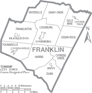
Towns
- Bunn
- Franklinton
- Louisburg (county seat)
- Wake Forest (mostly in Wake County)
- Youngsville
- Castalia (partially)
Census-designated places
Unincorporated communities
- Alert
- Epsom
- Five Points
- Gold Sand
- Gupton
- Halls Crossroads
- Harris Crossroads
- Hickory Rock
- Ingleside
- Katesville
- Kearney
- Justice
- Laurel Mill
- Mapleville
- Margaret
- Mitchiners Crossroads
- Moulton
- Needmore
- New Hope
- Oswego
- Pearces
- Pilot
- Pine Ridge
- Pocomoke
- Raynor
- Riley
- Rocky Ford
- Royal
- Schloss
- Seven Paths
- Stallings Crossroads
- Sutton
- White Level
- Wilders Corner
- Wood
Townships
- Cedar Rock
- Cypress Creek
- Dunn
- Franklinton
- Gold Sand
- Harris
- Hayesville
- Louisburg
- Sandy Creek
- Youngsville
See also
References
- "State & County QuickFacts". United States Census Bureau. Archived from the original on June 6, 2011. Retrieved October 19, 2013.
- "Find a County". National Association of Counties. Archived from the original on 2011-05-31. Retrieved 2011-06-07.
- "Population Estimates 2012 Combined Statistical Areas: April 1, 2010 to July 1, 2012". U.S. Census Bureau. Archived from the original on March 17, 2013. Retrieved 2013-03-14.
- Gannett, Henry (1905). The Origin of Certain Place Names in the United States. Govt. Print. Off. pp. 131.
- "An Oral History of School Desegregation in Franklin County, North Carolina". July 4, 2016. Archived from the original on July 4, 2016.
- Louisburg College (March 29, 2018). "County Schools Fully Desegregated Fifty Years Ago" (PDF).
- Willard, George-Anne. Franklin County Sketchbook. Louisburg, NC: Franklin County-Louisburg Bicentenary Committee, 1982.
- "2010 Census Gazetteer Files". United States Census Bureau. August 22, 2012. Archived from the original on January 12, 2015. Retrieved January 14, 2015.
- "Population and Housing Unit Estimates". Retrieved July 22, 2019.
- "U.S. Decennial Census". United States Census Bureau. Retrieved January 14, 2015.
- "Historical Census Browser". University of Virginia Library. Retrieved January 14, 2015.
- Forstall, Richard L., ed. (March 27, 1995). "Population of Counties by Decennial Census: 1900 to 1990". United States Census Bureau. Retrieved January 14, 2015.
- "Census 2000 PHC-T-4. Ranking Tables for Counties: 1990 and 2000" (PDF). United States Census Bureau. April 2, 2001. Retrieved January 14, 2015.
- "U.S. Census website". United States Census Bureau. Retrieved 2015-01-17.
- Franklin County, North Carolina (Commissioners), Retrieved Nov. 3, 2015.
- Franklin County, North Carolina (Services), Retrieved Nov. 3, 2015.
- Franklin County Sheriff's Office, Retrieved Nov. 3, 2015.
- Lake Royale Police Department, Retrieved Nov. 3, 2015.
- North Carolina Department of Public Safety, Troop C - Raleigh Archived 2015-11-25 at the Wayback Machine, Retrieved Nov. 4, 2015.
- Kerr-Tar Regional Council of Governments, Retrieved Nov. 4, 2015.
- Leip, David. "Dave Leip's Atlas of U.S. Presidential Elections". uselectionatlas.org. Retrieved 2018-03-15.
External links
- Official website
- Greater Franklin County Chamber of Commerce
- Franklin County Sheriff's Office
- Franklin County News Online newspaper
- The Franklin Times newspaper
- Franklin County Schools
Places adjacent to Franklin County, North Carolina | ||||||||||
|---|---|---|---|---|---|---|---|---|---|---|
| ||||||||||
Municipalities and communities of Franklin County, North Carolina, United States | ||
|---|---|---|
| Towns | 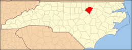 | |
| CDP | ||
| Unincorporated communities | ||
| Footnotes | ‡This populated place also has portions in an adjacent county or counties | |
Greater Raleigh Metropolitan Region (Raleigh-Cary MSA, part of the Research Triangle) | ||
|---|---|---|
| Principal cities | 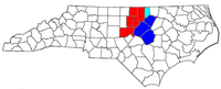 | |
| Other significant cities | ||
| Counties | ||
| Major universities |
| |
| Transportation | ||
| Miscellaneous | ||


| Authority control |
|
|---|