Durham County, North Carolina
Durham County is a county located in the U.S. state of North Carolina. As of the 2010 census, the population was 267,587, making it the sixth-most populous county in North Carolina.[1] Its county seat is Durham.[2]
Durham County | |
|---|---|
 Old Durham County Courthouse | |
 Seal  Logo | |
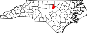 Location within the U.S. state of North Carolina | |
 North Carolina's location within the U.S. | |
| Coordinates: 36°02′N 78°52′W | |
| Country | |
| State | |
| Founded | 1881 |
| Named for | Bartlett Snipes Durham |
| Seat | Durham |
| Largest city | Durham |
| Area | |
| • Total | 298 sq mi (770 km2) |
| • Land | 286 sq mi (740 km2) |
| • Water | 12 sq mi (30 km2) 4.0%% |
| Population | |
| • Estimate (2019) | 321,488 |
| • Density | 1,015.4/sq mi (392.0/km2) |
| Time zone | UTC−5 (Eastern) |
| • Summer (DST) | UTC−4 (EDT) |
| Congressional districts | 1st, 4th |
| Website | www |
Durham County is the core of the Durham-Chapel Hill, NC Metropolitan Statistical Area, which is also included in the Raleigh-Durham-Cary, NC Combined Statistical Area, which had a population of 1,749,525 in 2010.
History
The county was formed on April 17, 1881, from parts of Orange County and Wake County, taking the name of its own county seat. In 1911 parts of Cedar Fork Township of Wake County was transferred to Durham County and became Carr Township.
Geography
According to the U.S. Census Bureau, the county has a total area of 298 square miles (770 km2), of which 286 square miles (740 km2) is land and 12 square miles (31 km2) (4.0%) is water.[3]
Demographics
| Historical population | |||
|---|---|---|---|
| Census | Pop. | %± | |
| 1890 | 18,041 | — | |
| 1900 | 26,233 | 45.4% | |
| 1910 | 35,276 | 34.5% | |
| 1920 | 42,219 | 19.7% | |
| 1930 | 67,196 | 59.2% | |
| 1940 | 80,244 | 19.4% | |
| 1950 | 101,639 | 26.7% | |
| 1960 | 111,995 | 10.2% | |
| 1970 | 132,681 | 18.5% | |
| 1980 | 152,785 | 15.2% | |
| 1990 | 181,835 | 19.0% | |
| 2000 | 223,314 | 22.8% | |
| 2010 | 267,587 | 19.8% | |
| Est. 2019 | 321,488 | [4] | 20.1% |
| U.S. Decennial Census[5] 1790-1960[6] 1900-1990[7] 1990-2000[8] 2010-2013[1] | |||
As of the census[9] of 2000, there were 223,314 people, 89,015 households, and 54,032 families residing in the county. The population density was 769 people per square mile (297/km²). There were 95,452 housing units at an average density of 329 per square mile (127/km²). The racial makeup of the county was 50.91% White, 39.46% Black or African American, 0.30% Native American, 3.29% Asian, 0.04% Pacific Islander, 4.21% from other races, and 1.80% from two or more races. 7.63% of the population were Hispanic or Latino of any race.
There were 89,015 households out of which 29.10% had children under the age of 18 living with them, 42.00% were married couples living together, 14.80% had a female householder with no husband present, and 39.30% were non-families. 30.00% of all households were made up of individuals and 7.00% had someone living alone who was 65 years of age or older. The average household size was 2.40 and the average family size was 2.99.
In the county, the age distribution was as follows: 22.90% under the age of 18, 12.80% from 18 to 24, 34.80% from 25 to 44, 19.80% from 45 to 64, and 9.70% who were 65 years of age or older. The median age was 32 years. For every 100 females there were 93.00 males. For every 100 females age 18 and over, there were 89.70 males.
The median income for a household in the county was $43,337, and the median income for a family was $53,223. Males had a median income of $35,939 versus $30,683 for females. The per capita income for the county was $23,156. About 9.80% of families and 13.40% of the population were below the poverty line, including 17.20% of those under age 18 and 12.30% of those age 65 or over.
Law and government
Durham County is a member of the regional Triangle J Council of Governments. Durham County is governed by a five-member board of county commissioners, currently consisting of Chair Wendy Jacobs, Vice Chair James Hill, Brenda A. Howerton, Heidi Carter, and Ellen W. Reckhow.[10] Each elected member serves a four-year term.
| Year | Republican | Democratic | Third parties |
|---|---|---|---|
| 2016 | 18.2% 28,350 | 77.7% 121,250 | 4.2% 6,534 |
| 2012 | 23.0% 33,769 | 75.8% 111,224 | 1.2% 1,742 |
| 2008 | 23.6% 32,353 | 75.6% 103,456 | 0.8% 1,088 |
| 2004 | 31.6% 34,614 | 68.0% 74,524 | 0.5% 513 |
| 2000 | 35.6% 30,150 | 63.7% 53,907 | 0.7% 547 |
| 1996 | 34.4% 27,825 | 60.8% 49,186 | 4.8% 3,899 |
| 1992 | 33.4% 27,581 | 57.2% 47,331 | 9.4% 7,770 |
| 1988 | 45.4% 29,928 | 53.8% 35,441 | 0.8% 514 |
| 1984 | 47.4% 29,185 | 52.4% 32,244 | 0.3% 155 |
| 1980 | 40.2% 19,276 | 52.1% 24,969 | 7.6% 3,656 |
| 1976 | 45.6% 18,945 | 54.0% 22,425 | 0.4% 163 |
| 1972 | 61.4% 25,576 | 37.4% 15,566 | 1.3% 525 |
| 1968 | 29.7% 12,705 | 38.7% 16,563 | 31.6% 13,542 |
| 1964 | 40.0% 15,264 | 60.0% 22,874 | |
| 1960 | 42.6% 14,322 | 57.4% 19,298 | |
| 1956 | 48.9% 13,226 | 51.1% 13,835 | |
| 1952 | 37.4% 11,301 | 62.6% 18,897 | |
| 1948 | 25.7% 4,531 | 65.5% 11,530 | 8.8% 1,552 |
| 1944 | 22.4% 3,690 | 77.6% 12,763 | |
| 1940 | 14.4% 2,491 | 85.6% 14,810 | |
| 1936 | 14.6% 2,189 | 85.4% 12,804 | |
| 1932 | 25.9% 2,770 | 70.8% 7,559 | 3.3% 351 |
| 1928 | 66.1% 8,723 | 33.9% 4,482 | |
| 1924 | 38.0% 3,093 | 59.3% 4,837 | 2.7% 221 |
| 1920 | 43.3% 3,550 | 56.7% 4,646 | |
| 1916 | 42.7% 1,837 | 57.3% 2,463 | |
| 1912 | 3.5% 124 | 62.3% 2,197 | 34.2% 1,205 |
Communities
The city of Durham is the only incorporated municipality to predominantly exist within Durham County, and the only one whose urban core lies within the county, though small portions of municipalities from neighboring counties extend into Durham County, and the city of Durham also itself extends slightly into neighboring counties. All other towns and places within Durham County are unincorporated communities.
Cities
Towns
- Chapel Hill (small part, mostly in Orange County)
- Morrisville (small part, mostly in Wake County)
Census-designated places
- Gorman
- Rougemont (small portions extend into neighboring Person County)
References
- "State & County QuickFacts". United States Census Bureau. Archived from the original on June 6, 2011. Retrieved October 19, 2013.
- "Find a County". National Association of Counties. Archived from the original on 2012-07-12. Retrieved 2011-06-07.
- "2010 Census Gazetteer Files". United States Census Bureau. August 22, 2012. Archived from the original on January 12, 2015. Retrieved January 14, 2015.
- "Population and Housing Unit Estimates". Retrieved March 28, 2020.
- "U.S. Decennial Census". United States Census Bureau. Retrieved January 14, 2015.
- "Historical Census Browser". University of Virginia Library. Retrieved January 14, 2015.
- Forstall, Richard L., ed. (March 27, 1995). "Population of Counties by Decennial Census: 1900 to 1990". United States Census Bureau. Retrieved January 14, 2015.
- "Census 2000 PHC-T-4. Ranking Tables for Counties: 1990 and 2000" (PDF). United States Census Bureau. April 2, 2001. Retrieved January 14, 2015.
- "U.S. Census website". United States Census Bureau. Retrieved 2008-01-31.
- Leip, David. "Dave Leip's Atlas of U.S. Presidential Elections". uselectionatlas.org. Retrieved 2018-03-15.
- Raleigh Durham Annexation Agreement Lines Archived October 19, 2011, at the Wayback Machine
External links
| Wikimedia Commons has media related to Durham County, North Carolina. |
- Durham County Government official website
- Durham Convention and Visitors Bureau
- Durham County Library website
- Greater Durham Chamber of Commerce
- North Carolina Room of the Durham County Library Website for an archive which collects materials concerning the city and county of Durham
Places adjacent to Durham County, North Carolina | ||||||||||
|---|---|---|---|---|---|---|---|---|---|---|
| ||||||||||
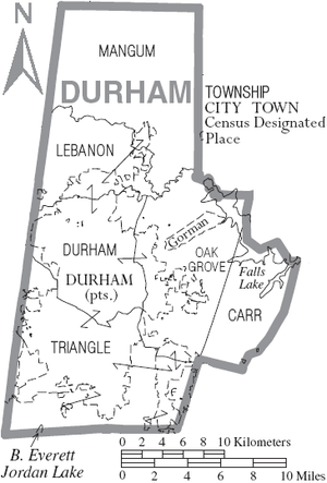
Municipalities and communities of Durham County, North Carolina, United States | ||
|---|---|---|
| Cities |  | |
| Towns | ||
| Townships | ||
| CDPs | ||
| Unincorporated communities | ||
| Footnotes | ‡This populated place also has portions in an adjacent county or counties | |
Greater Durham-Chapel Hill Metropolitan Region (Durham MSA, part of the Research Triangle) | ||
|---|---|---|
| Principal cities | 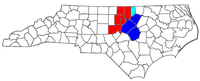 | |
| Other significant cities | ||
| Counties | ||
| Major universities | ||
| Transportation |
| |
| Newspapers | ||
| Miscellaneous | ||
Greater Raleigh Metropolitan Region (Raleigh-Cary MSA, part of the Research Triangle) | ||
|---|---|---|
| Principal cities | | |
| Other significant cities | ||
| Counties | ||
| Major universities |
| |
| Transportation | ||
| Miscellaneous | ||


| Authority control |
|
|---|