Outer Banks
The Outer Banks are a 200-mile-long (320 km) string of barrier islands and spits off the coast of North Carolina and southeastern Virginia, on the east coast of the United States. They cover most of the North Carolina coastline, separating Currituck Sound, Albemarle Sound, and Pamlico Sound from the Atlantic Ocean.
The Outer Banks is a major tourist destination and are known for their wide expanse of open beachfront. The Cape Hatteras National Seashore has four campgrounds open to visitors.[1] The treacherous seas off the Outer Banks and the large number of shipwrecks that have occurred there have given these seas the nickname Graveyard of the Atlantic. The Graveyard of the Atlantic Museum is located in Hatteras Village near a United States Coast Guard facility and the Hatteras ferry. The popular Netflix series "Outer Banks" was not filmed there but was based on the area.
The English Roanoke Colony—where Virginia Dare was born[2]—vanished from Roanoke Island in 1587. The Lost Colony, written and performed today on Roanoke Island to commemorate the original colonists, is the second longest-running outdoor drama in the United States and its theater acts as a cultural focal point for much of the Outer Banks.
The Wright brothers' first flight in a controlled, powered, heavier-than-air vehicle took place on the Outer Banks on December 17, 1903, at Kill Devil Hills near the seafront town of Kitty Hawk.[3] The Wright Brothers National Monument commemorates the historic flights, and First Flight Airport is a small, general-aviation airfield located there.
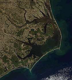
Geography
International Space Station
(north = upper right; April 2019)
The Outer Banks is a string of peninsulas and barrier islands separating the Atlantic Ocean from mainland North Carolina. From north to south, the largest of these include: Bodie Island (which used to be an island but is now a peninsula due to tropical storms and hurricanes), Hatteras Island, Ocracoke Island, Portsmouth Island, and the Core Banks.[4] Over time, the exact number of islands and inlets changes as new inlets are opened up, often during a breach created during violent storms, and older inlets close, usually due to gradually shifting sands during the dynamic processes of beach evolution.
The Outer Banks stretch southward from Sandbridge in Virginia Beach down the North Carolina coastline. Sources differ regarding the southern terminus of the Outer Banks. Generations of North Carolina schoolchildren have learned that the term includes the state's three prominent capes: Cape Hatteras, Cape Lookout, and Cape Fear.[5][6] Other sources limit the definition to two capes (Cape Hatteras and Cape Lookout) and coastal areas in four counties (Currituck County, Dare County, Hyde County,and Carteret County).[7] Some authors include Carteret's Shackelford Banks and Bogue Banks in their descriptions,[7] while others exclude Bogue Banks.[8] Still other references restrict the definition to the northern three counties of Currituck, Dare, and Hyde.[9]
The abbreviations OBX (Outer Banks) and SOBX (Southern Outer Banks) are modern terms used to promote tourism and to market a variety of stickers, t-shirts, and other items to vacationers. OBX, which originated first, is generally used in the northern Outer Banks. SOBX is a misnomer, used to capitalize on the popularity of "OBX" and refers to the Crystal Coast area and the Bogue Banks.
The northern part of the Outer Banks, from Oregon Inlet northward, is actually a part of the North American mainland, since the northern inlets of Bodie Island and Currituck Banks no longer exist.[10] It is separated by the Currituck Sound and the Intracoastal Waterway, which passes through the Great Dismal Swamp occupying much of the mainland west of the Outer Banks. Road access to the northern Outer Banks is cut off between Sandbridge and Corolla, North Carolina, with communities such as Carova Beach accessible only by four-wheel drive vehicles. North Carolina State Highway 12 links most of the popular Outer Banks communities in this section of the coast. The easternmost point is Rodanthe Pier in Rodanthe, NC .
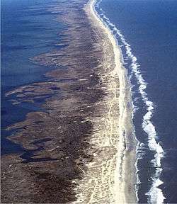
The Outer Banks are not anchored to offshore coral reefs like some other barrier islands and as a consequence they often suffer significant beach erosion during major storms. In fact, their location jutting out into the Atlantic makes them the most hurricane-prone area north of Florida, for both landfalling storms and brushing storms offshore. Hatteras Island was cut in half on September 18, 2003, when Hurricane Isabel washed a 2,000 foot (600 m) wide and 15 foot (5 m) deep channel called Isabel Inlet through the community of Hatteras Village on the southern end of the island.[11] The tear was subsequently repaired and restored by sand dredging by the U.S. Army Corps of Engineers. It was cut off once again in 2011 by Hurricane Irene. Access to the island was largely limited to boat access only from August to late October until another temporary bridge could be built.

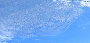
(north = lower left; April 2019)
Vegetation
The vegetation of the Outer Banks has biodiversity, although it is considered the northern limit for many southern plants such as wild scrub palms. In the northeast part of the Outer Banks, from Virginia Beach southward past the North Carolina border to Oregon Inlet, the main types of vegetation are sea grasses, beach grasses and other beach plants including Opuntia humifusa on the Atlantic side and wax myrtles, bays, and grasses on the Sound side with areas of pine and Spanish moss-covered live oaks. Yucca aloifolia and Yucca gloriosa can be found growing wild here in the northern parts of its range on the beach. Sabal Minor palms were once indigenous to the entire Outer Banks, and they are still successfully planted and grown. Its current most northerly known native stand is on Monkey Island in Currituck County.[12][13]
From Cape Hatteras National Seashore southward, the vegetation does include that of the northeastern Outer Banks such as Dwarf palmetto (Sabal minor), Yucca aloifolia and Yucca gloriosa; however, the main vegetation consists of Cabbage palmetto (Sabal palmetto), which can be found in the north, although they are native in the southern part of the Outer Banks, specifically prevalent from Cape Hatteras and all points southward. Pindo palms and windmill palms are also planted widely throughout the Outer Banks; although, they are not indigenous to the area.
A wide variety of native plants can be found at the Elizabethan Gardens in Manteo on Roanoke Island.[14]
Climate
The Outer Banks has a humid subtropical climate. The outer banks have unusual weather patterns because of their unique geographical location. As the islands are jutted out from the eastern seaboard into the Atlantic Gulf Stream, the Outer Banks has a predisposition to be affected by hurricanes, Nor'easters (usually in the form of rain, and rarely snow or mixed precipitation), and other ocean-driven storms.
The winters are typically milder than in inland areas, averaging lows in the upper 30s and highs in the lower 50s, and is more frequently overcast than in the summer. However, the exposure of the Outer Banks makes them prone to higher winds, often causing wind chills to make the apparent temperature as cold as the inland areas. The summer months average lows from the mid-70s to highs in the upper 80s, depending on the time of the summer. The spring and fall are typically milder seasons. The fall and winter are usually warmer than areas inland, while the spring and the summer are often slightly cooler because of the moderating effects of being surrounded by water.
Although snow is possible, averaging from 3 inches in the north to less than 1/2 inch per year in the south, there are many times when years pass between snowfalls.[15] The majority of nor'easters are "born" off the coasts of the Outer Banks.
Culture
The Outer Banks is one of the most culturally distinctive areas of the East Coast of the United States.[16] The Outer Banks were inhabited before the arrival of Europeans, with small branches of larger tribes, such as the Algonquin speaking Chowanoke, Secotan and Poteskeet living semi nomadic lives. Oftentimes Native Americans would use the barrier islands facing the Atlantic Ocean for fishing in the summer, and reside on Roanoke Island or the North Carolina mainland in the winter.
European explorers to the Outer Banks as far back as the 1500s noted encountering the friendly Hatteras Island and Outer Banks Natives, noting their hospitality to foreign explorers as well as their happiness and overall quality of life. European-borne diseases and migration to the mainland were likely the main causes for the decline of the Native population.[17]
Before bridges were built in the 1930s, the only form of transport between or off the islands was by boat, which allowed for the islands to stay isolated from much of the rest of the mainland. This helped to preserve the maritime culture and the distinctive Outer Banks accent or brogue, which sounds more like an English accent than it does an American accent. Many "bankers" have often been mistaken for being from England or Ireland when traveling to areas outside of the Outer Banks. The brogue is more distinctive the further south one travels on the Outer Banks, with it being the thickest on Ocracoke Island and Harkers Island.
Some residents of the Outer Banks, known as wreckers, made part of their living by scavenging wrecked ships—or by luring ships to their destruction. Horses with lanterns tied to their necks would be walked along the beach; the lanterns' up and down motion would appear to ships to represent clear water and a ship ahead; the unsuspecting captain would then drive his ship ashore following this false light.[18]
The islands are home to herds of feral horses, sometimes called "banker ponies", which according to local legend are descended from Spanish mustangs washed ashore centuries ago in shipwrecks. Populations are found on Ocracoke Island, Shackleford Banks, Currituck Banks, and in the Rachel Carson Estuarine Sanctuary.
Ocracoke was the last refuge of pirate Edward Teach, better known as Blackbeard. It is also where the infamous pirate was killed November 22, 1718 in a fierce battle with troops from Virginia.[19]
The Outer Banks are home to Yaupon Holly (Ilex vomitoria), the roasted leaves of which were brewed into a high caffeine beverage called black drink by the Native Americans. The Outer Banks may be one of the few places where it is still consumed.[20]
Economy
Major industries of the region include commercial fishing, boat building and tourism. Since the 1990s the rise of tourism, has led the region to become an increasingly service oriented economy.
There has been a long history of fishing in the Outer Banks, dating back to the end of the 17th century.[21] Pirates ravaged the coast for the majority of the 1600s, but once they were ridden, the local settlers used fishing as their lifeline.[21]
In the mid-19th century, large-scale commercial fishing erupted, mostly due to the construction of the Albemarle and Chesapeake Canal, which simplified shipping methods for fishermen.[21] Saltwater fishing became the cash-crop of the Outer Banks, and blossomed it into a popular tourist destination.[21] In modern times, tourists will flock to the area just for the abundance of fishing opportunities.[22] Anglers, otherwise known as fishermen, have a wide range of fishing methods, some of these methods date back to when the first settlers arrived, to choose from in the Outer Banks.[21]
Lighthouses
There are 6 lighthouses in the Outer Banks[23]
- Currituck Beach Lighthouse, located in Corolla, North Carolina
- Roanoake Marshes Lighthouse, located in Manteo, North Carolina
- Bodie Island Lighthouse, located south of Nags Head, North Carolina
- Cape Hatteras Lighthouse, located in Buxton, North Carolina
- Ocracoke Island Lighthouse, located in Ocracoke, North Carolina
- Cape Lookout Lighthouse, located in Carteret County, North Carolina
Communities
Towns and communities along the Outer Banks include (listed from north to south):
Currituck Banks
Bodie Island


Ocracoke Island
Core Banks
- Portsmouth Island
Parks

- Back Bay National Wildlife Refuge
- Cape Hatteras National Seashore
- Cape Lookout National Seashore
- Currituck Heritage Park
- Currituck National Wildlife Refuge
- False Cape State Park
- Fort Macon State Park
- Fort Raleigh National Historic Site
- Jockey's Ridge State Park
- Mackay Island National Wildlife Refuge
- Pea Island National Wildlife Refuge
- Wright Brothers National Memorial
Notable residents
- Dennis Anderson, professional Monster Truck driver and creator of Grave Digger.
- Marc Basnight, (born 1947), former member of the North Carolina State Senate
- Andy Griffith (1926–2012), actor[24]
- Alexis Knapp, (born 1989), actress
- Edward Teach (1680-1718), notorious English pirate better known as "Blackbeard," raided on the North Atlantic and Caribbean Sea.
- Manteo (disappeared after 1587) influential figure in the Croatoan Nation, ambassador to England and mediator.
- Wanchese (disappeared after 1587) influential figure in the Roanoke Nation, opposed English colonization.
See also
References
- "Campgrounds". Retrieved 1 April 2016.
- "England's First Home in the New World". Fort Raleigh National Historic Site. National Park Service.
- "Telegram from Orville Wright in Kitty Hawk, North Carolina, to His Father Announcing Four Successful Flights, 1903 December 17". World Digital Library. 1903-12-17. Retrieved 2013-07-21.
- "Geography of North Carolina". NC State Board of Education.
- "Geography of North Carolina". www.ncpublicschools.org. Retrieved 2016-04-09.
- "Library of Congress LCCN Permalink sh85096155". lccn.loc.gov. Retrieved 2016-04-10.
- "North Carolina Gazetteer | NCpedia". ncpedia.org. Retrieved 2016-04-10.
- "Outer Banks | island chain, United States". Encyclopædia Britannica. Retrieved 2016-04-10.
- "Outer Banks Map". OuterBanks.com. Retrieved 10 April 2016.
- "Corolla History". Retrieved 1 April 2016.
- "Shoring Up N. Carolina Islands: A Losing Battle?". Retrieved 1 April 2016.
- "Monkey Island Sabal Minor". Old Dominion University. Retrieved 1 November 2013.
- "Gary's Nursery". Gary Hollar. Retrieved 1 November 2013.
- "Elizabethan Gardens - Welcome to Our Lovely Gardens". Elizabethan Gardens. Retrieved 1 April 2016.
- "Back Bay National Wildlife Refuge VA Weather Forecast". WillyWeather. Retrieved 3 September 2019.
- Wolfram, Walt; Reaser, Jeffrey (2014). Talkin' Tar Heel : How Our Voices Tell the Story of North Carolina. Chapel Hill: The University of North Carolina Press. p. 101. ISBN 978-1-4696-1437-3.
- "First Settlers". OuterBanks.com.
- "Graveyard of the Atlantic - North Carolina Digital History". Retrieved 1 April 2016.
- D. Moore. (1997) "A General History of Blackbeard the Pirate, the Queen Anne's Revenge and the Adventure". In Tributaries, Volume VII, 1997. pp. 31–35. (North Carolina Maritime History Council)
- Dough, Wynne. "Yaupon". NCpedia. Retrieved 24 January 2017.
- "Gloucester vs. Outer Banks". National Geographic Channel. Retrieved 1 April 2016.
- "Outer Banks Fishing". The Outer Banks of North Carolina. Retrieved 21 January 2016.
- "Outer Banks Lighthouses". OuterBanks.com.
- Vincent, Mal (February 17, 2008). "The real Andy Griffith lives among us, quietly". The Virginian-Pilot. Retrieved September 20, 2009.
External links
![]()
![]()


| Authority control |
|
|---|