Alexander County, North Carolina
Alexander County is a county established in the U.S. state of North Carolina in 1847. As of the 2010 census, the population was 37,198.[1] Its county seat is Taylorsville.[2][3]
Alexander County | |
|---|---|
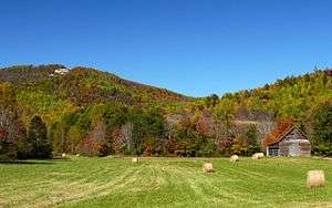 The Brushy Mountains in Alexander County | |
 Seal | |
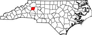 Location within the U.S. state of North Carolina | |
 North Carolina's location within the U.S. | |
| Coordinates: 35°55′N 81°11′W | |
| Country | |
| State | |
| Founded | 1847 |
| Named for | William Julius Alexander |
| Seat | Taylorsville |
| Largest town | Taylorsville |
| Area | |
| • Total | 264 sq mi (680 km2) |
| • Land | 260 sq mi (700 km2) |
| • Water | 3.7 sq mi (10 km2) 1.4%% |
| Population | |
| • Estimate (2019) | 37,497 |
| • Density | 143/sq mi (55/km2) |
| Time zone | UTC−5 (Eastern) |
| • Summer (DST) | UTC−4 (EDT) |
| Congressional district | 5th |
| Website | alexandercountync |
Alexander County is part of the Hickory–Lenoir–Morganton, NC Metropolitan Statistical Area.
History
Alexander County was formed in 1847 from portions of what were then Iredell (formed in 1788 from Rowan County), Caldwell (formed from Burke County in 1841), and Wilkes (formed from Surry County and Washington District in 1771) counties. Alexander County was named for William Julius Alexander who was a Speaker of the North Carolina House of Commons. This Piedmont area was settled primarily by farmers, many of Scots-Irish descent, as well as German descent in the southern section of Alexander County.[4][5]


Alexander County was established by two acts of the North Carolina General Assembly, one ratified on January 15 and one ratified on January 18, 1847. These acts were not to take effect until it was determined that Caldwell County would have 5,000 people in it. On August 10–11, 1847, the first sale of land in the county seat (Taylorsville) took place. Taylorsville is the namesake of either John Louis Taylor, Carolina agriculturist and political philosopher, or General Zachary Taylor, the twelfth president of the United States. With the proceeds from the sale, the county built the first courthouse on the present site.[6]
When the American Civil War began, Alexander County was fourteen years old. The 1860 population was 5,837; yet Alexander County ranked high per capita in the number of Confederate soldiers it sent to the war. The court house records in Taylorsville were destroyed by troops under Major General George Stoneman in a raid on Easter Sunday in 1865.[7]
Geography
According to the U.S. Census Bureau, the county has a total area of 264 square miles (680 km2), of which 260 square miles (670 km2) is land and 3.7 square miles (9.6 km2) (1.4%) is water.[8]
Alexander County is located within the Foothills region of western North Carolina. The county's main geographic feature is the Brushy Mountains, a deeply eroded spur of the Blue Ridge Mountains to the west. The "Brushies," as they are called locally, rise from 300 to 1,000 feet (300 m) above the surrounding countryside, and dominate the county's northern horizon. The highest point in Alexander County is Hickory Knob in the Brushies; it has an elevation of 2,560 feet (780 m) above sea level. Barrett Mountain, an isolated mountain ridge, is in the western part of the county. The remainder of Alexander County's terrain consists of gently rolling countryside. The county's largest river, the Catawba, forms its southern border.
Within Alexander County is the unincorporated town of Hiddenite, the location of a mine that yields emeralds, sapphires, and its namesake stone "hiddenite," a variety of spodumene.
The county is served by US Highway 64, a controlled-access roadway connecting Taylorsville with Lenoir and Statesville. NC Highways 90, 16, and 127 also serve the county. Interstate 40 and 77 are 30 minutes from the majority of county residents. The Charlotte Douglas International Airport is an hour's drive from most parts of the county. The area is also served by the Hickory Regional Airport (30 minutes) and the Statesville Airport (20 minutes). The Alexander Railroad Company is an active short-line rail system operating between Taylorsville and Statesville, and connecting with Norfolk Southern.
Demographics
| Historical population | |||
|---|---|---|---|
| Census | Pop. | %± | |
| 1850 | 5,220 | — | |
| 1860 | 6,022 | 15.4% | |
| 1870 | 6,868 | 14.0% | |
| 1880 | 8,355 | 21.7% | |
| 1890 | 9,430 | 12.9% | |
| 1900 | 10,960 | 16.2% | |
| 1910 | 11,592 | 5.8% | |
| 1920 | 12,212 | 5.3% | |
| 1930 | 12,922 | 5.8% | |
| 1940 | 13,454 | 4.1% | |
| 1950 | 14,554 | 8.2% | |
| 1960 | 15,625 | 7.4% | |
| 1970 | 19,466 | 24.6% | |
| 1980 | 24,999 | 28.4% | |
| 1990 | 27,544 | 10.2% | |
| 2000 | 33,603 | 22.0% | |
| 2010 | 37,198 | 10.7% | |
| Est. 2019 | 37,497 | [9] | 0.8% |
| U.S. Decennial Census[10] 1790-1960[11] 1900-1990[12] 1990-2000[13] 2010-2014[1] | |||
As of the census[14] of 2000, there were 33,603 people, 13,137 households, and 9,747 families residing in the county. The population density was 129 people per square mile (50/km²). There were 14,098 housing units at an average density of 54 per square mile (21/km²). The racial makeup of the county was 92.00% White, 4.63% Black or African American, 0.15% Native American, 1.04% Asian, 1.34% from other races, and 0.84% from two or more races. 2.50% of the population were Hispanic or Latino of any race.
There were 13,137 households out of which 32.80% had children under the age of 18 living with them, 60.50% were married couples living together, 9.40% had a female householder with no husband present, and 25.80% were non-families. 21.90% of all households were made up of individuals and 8.40% had someone living alone who was 65 years of age or older. The average household size was 2.54 and the average family size was 2.95.
In the county, the population was spread out with 24.50% under the age of 18, 7.90% from 18 to 24, 31.10% from 25 to 44, 24.60% from 45 to 64, and 11.90% who were 65 years of age or older. The median age was 37 years. For every 100 females there were 99.40 males. For every 100 females age 18 and over, there were 96.70 males.
The median income for a household in the county was $38,684, and the median income for a family was $45,691. Males had a median income of $29,857 versus $21,868 for females. The per capita income for the county was $18,507. About 5.90% of families and 8.50% of the population were below the poverty line, including 10.20% of those under age 18 and 14.60% of those age 65 or over.
Communities
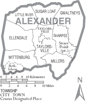
Town
- Taylorsville (county seat since 1847): First post master was Alexander C. McIntosh. Post office since 11/26/1847. Formerly called James Cross Roads in Iredell County prior to 1847.
Townships
By the requirements of the North Carolina Constitution of 1868, counties were divided into non-functioning county subdivisioninto called townships. There are eight townships in Alexander County:[15][16]
- Ellendale
- Gwaltneys
- Little River
- Millers
- Sharpes
- Sugar Loaf
- Taylorsville
- Wittenburg
Census-designated places
- Bethlehem
- Hiddenite: First postmaster was Quintis C. Patterson. Post office since February 10, 1888.
- Stony Point: First postmaster was John A. Murchison. Post office since October 21, 1847.
Unincorporated communities
Unincorporated communities in Alexander County include:[16]
- Drumstand: Site of Drumstand community building[17]
- Ellendale: The first postmaster was William S. McLeod. Post office from July 1, 1880 to January 30, 1904.
- Little River: The first postmaster was Burton Reid. Post office from November 10, 1852 to September 15, 1906. 1841 to 1847 part of Caldwell County, part of Burke County before 1841.
- Millersville[17]
- Sugar Loaf[17]
- Vashti: The first postmaster was Humphrey T. Cambell. Post office from February 12, 1886 to March 31, 1903.
- Wittenburg(s): The first postmaster was Joseph B. Bradburn. Post office from May 31, 1848 to March 15, 1909. Before 1847, part of Caldwell County.
Historic post offices and other sites
Historical post offices that were part of Alexander County include:[16]
- Mount Pisgah: First postmaster was Reuben O. Bennett. Post office from April 9, 1849 to April 15, 1909.
- Elk Shoal: First postmaster was Ephraim M. Alexander. Post office from March 5, 1852 to November 26, 1852. Post office changed to Elk Shoal #2 on September 27, 1858 with David M. Moore as post master. Became part of Iredell County in 1868. Changed to Elk Shoal #3 in 1881 and became part of Alexander County. New postmaster was Nicholas L. Norton on August 4, 1881. Post office discontinued on January 15, 1901.
- York Collegiate Institute: First postmaster was Richard W. York. Post office from December 13, 1855 to April 2, 1859. Name was changed to Montane Female Academy on April 2, 1859 with Thaddeus L. Troy as postmaster until November 28, 1859 when the name was changed back to York Collegiate Institute with Harrison L. Smith as postmaster. Post office discontinued on December 4, 1903.
- Salem Grove: First postmaster was William W. Teague. Post office lasted from August 7 to August 9, 1872.
- Jumping Run: First postmaster was James F. Gryder. Post office from August 15, 1871 to October 15, 1872.
- Cedar Run: First postmaster was John H. Ellis. Post office from February 9, 1876 to September 14, 1903.
- Little River: First postmaster was Burton Reid. Post office from November 10, 1952 to September 15, 1906. Formerly in Burke County before 1841 and Caldwell County in 1841.
- Mount Bethel: First postmaster was Adam P. Bohick. Post office from May 8, 1876 to March 15, 1913.
- Barnetts Mountain: First postmaster was David L. Mitchell. Post office from December 29, 1876 to April 13, 1881.
- Kilby: First postmaster was Leander R. Goforth. Post office from May 3, 1880 to May 15, 1905.
- Pilgrim: First postmaster was William E. Millsope. Post office from June 30, 1880 to October 15, 1882.
- Bentley: First postmaster was William W. Teague. Post office from January 24, 1881 to September 30, 1941.
- Hedrick: First postmaster was Edward L. Hedrick. Post office from October 7, 1881 to September 30, 1903.
- Broad Shoals: First postmaster was Thomas Little. Post office from October 31, 1881 to November 15, 1904.
- Grade: First postmaster was John P. Brewer. Post office from June 11, 1882 to May 15, 1900. Originally Iredell County and became Alexander County in 1888.
Other historic sites

- Old Jail Museum: 1919 jail in Taylorsville, now a museum[17]
- Lucas Mansion: Restored turn of the century home of James "Diamond Jim" Lucas in Hiddenite Center[17]
- Friendship Church: Lutheran and Evangelical church organized in 1833, near Taylorsville[4]
- Linney's Mill: Built in 1790 by Richard Cook. Located on the northeast corner of Alexander County, it is still operational.[18]
- Little River Baptist Church: first association meeting in 1771 (in what became Alexander County in 1847), church erected in 1786, originally called "Old Meeting House"[7]
Population ranking
The population of cities, towns, and Census Designated Places (CDP) is shown in the following table is based on the 2010 census of Alexander County.[19]
| Population Rank | City/Town/etc. | Municipal type | Population (2010 Census) |
|---|---|---|---|
| 1 | Bethlehem | CDP | 4,214 |
| 2 | Taylorsville (county seat) | Town | 2,098 |
| 3 | Stony Point (partially in Iredell County) | CDP | 1,317 |
| 4 | Hiddenite | CDP | 536 |
Politics, law and government
Alexander is currently a powerfully Republican county in Presidential elections. The only Democrat to carry the county in the past nineteen Presidential contests has been Jimmy Carter in 1976, although Barry Goldwater won the county by a mere thirty-eight votes in 1964. In contrast, Hillary Clinton in 2016 obtained barely twenty percent of the county's vote. The county did vote mainly Democratic during the Third Party System, but Populist sentiments in the 1890s have meant the county has supported that party only five times since 1896.
| Year | Republican | Democratic | Third parties |
|---|---|---|---|
| 2016 | 76.0% 13,893 | 20.6% 3,767 | 3.3% 611 |
| 2012 | 71.3% 12,253 | 26.8% 4,611 | 1.9% 332 |
| 2008 | 68.3% 11,790 | 30.0% 5,167 | 1.7% 297 |
| 2004 | 70.1% 10,928 | 29.6% 4,618 | 0.4% 54 |
| 2000 | 68.5% 9,242 | 30.9% 4,166 | 0.6% 84 |
| 1996 | 57.5% 6,748 | 33.7% 3,955 | 8.8% 1,027 |
| 1992 | 49.6% 6,764 | 35.6% 4,849 | 14.8% 2,013 |
| 1988 | 65.6% 7,968 | 34.1% 4,148 | 0.3% 38 |
| 1984 | 70.2% 8,502 | 29.6% 3,581 | 0.2% 24 |
| 1980 | 57.4% 6,376 | 40.9% 4,546 | 1.7% 187 |
| 1976 | 46.7% 4,661 | 53.0% 5,287 | 0.3% 27 |
| 1972 | 69.0% 5,865 | 29.0% 2,468 | 2.0% 173 |
| 1968 | 52.0% 4,379 | 21.8% 1,834 | 26.2% 2,203 |
| 1964 | 50.3% 3,760 | 49.8% 3,722 | |
| 1960 | 51.4% 4,175 | 48.7% 3,956 | |
| 1956 | 58.2% 3,767 | 41.8% 2,710 | |
| 1952 | 57.4% 3,597 | 42.6% 2,665 | |
| 1948 | 48.0% 2,314 | 42.7% 2,057 | 9.4% 452 |
| 1944 | 56.6% 2,971 | 43.4% 2,282 | |
| 1940 | 44.7% 2,217 | 55.3% 2,739 | |
| 1936 | 42.9% 2,451 | 57.1% 3,262 | |
| 1932 | 39.6% 1,952 | 59.9% 2,953 | 0.6% 28 |
| 1928 | 60.2% 2,605 | 39.8% 1,722 | |
| 1924 | 51.3% 2,437 | 48.3% 2,291 | 0.4% 20 |
| 1920 | 56.4% 2,643 | 43.6% 2,045 | |
| 1916 | 55.4% 1,187 | 44.6% 954 | |
| 1912 | 27.9% 523 | 45.5% 852 | 26.6% 497 |
Alexander County is a member of the regional Western Piedmont Council of Governments.
Transportation
Railroads
The county is served by one railroad, the Alexander Railroad Company.
See also
- National Register of Historic Places listings in Alexander County, North Carolina
- Category:People from Alexander County, North Carolina
References
- "State & County QuickFacts". United States Census Bureau. Archived from the original on June 6, 2011. Retrieved October 17, 2013.
- "Find a County". National Association of Counties. Archived from the original on 2011-05-31. Retrieved 2011-06-07.
- Vocci, Robert Blair (2006). "Alexander County, North Carolina". NCPedia. Retrieved August 8, 2019.
- Crouse, Andrew Leonhardt (1905). Historical Sketches of Alexander County, North Carolina, Friendship Lutheran Church, Hopewell Reformed Church, and Charity Baptist Church, and of the Bowman and Fry Families. Hickory, North Carolina.
- Martin, Jonathan. "Alexander County (1847)". North Carolina History Project. John Locke Foundation. Retrieved December 8, 2012.
- White, William E. (1926). Taylorsville Times (ed.). A History of Alexander County, North Carolina (PDF). Retrieved June 3, 2019.
- Lewis, J.D. "Alexander County, North Carolina". The American Revolution in North Carolina. Retrieved August 9, 2019.
- "2010 Census Gazetteer Files". United States Census Bureau. August 22, 2012. Archived from the original on January 12, 2015. Retrieved January 11, 2015.
- "Population and Housing Unit Estimates". Retrieved March 28, 2020.
- "U.S. Decennial Census". United States Census Bureau. Retrieved January 11, 2015.
- "Historical Census Browser". University of Virginia Library. Retrieved January 11, 2015.
- Forstall, Richard L., ed. (March 27, 1995). "Population of Counties by Decennial Census: 1900 to 1990". United States Census Bureau. Retrieved January 11, 2015.
- "Census 2000 PHC-T-4. Ranking Tables for Counties: 1990 and 2000" (PDF). United States Census Bureau. Retrieved January 11, 2015.
- "U.S. Census website". United States Census Bureau. Retrieved 2008-01-31.
- "North Carolina Constitution of 1868" (PDF). Retrieved May 10, 2019.
- Lewis, J.D. "Alexander County Post Offices". The American Revolution in North Carolina. Retrieved August 8, 2019.
- "Alexander County Comprehensive Plan" (PDF). Alexander County Board of Commissioners. April 21, 2008. Retrieved August 8, 2019.
- "Linney's Mill". Retrieved August 8, 2019.
- Promotions, Center for New Media and. "US Census Bureau 2010 Census". www.census.gov. Retrieved 2018-03-14.
- Leip, David. "Dave Leip's Atlas of U.S. Presidential Elections". uselectionatlas.org. Retrieved 2018-03-14.
- Powell, William S., ed. (2006). Alexander County. Encyclopedia of North Carolina (University of North Carolina Press: Chapel Hill, NC.
- Allen, Sara C. Allen, ed. (1985). The Heritage of Alexander County, North Carolina.
- Lewis, J.D. "Alexander County, North Carolina". The American Revolution in North Carolina. Retrieved June 3, 2019.
External links
- "County website". Retrieved August 7, 2019.
Places adjacent to Alexander County, North Carolina | ||||||||||
|---|---|---|---|---|---|---|---|---|---|---|
| ||||||||||
Municipalities and communities of Alexander County, North Carolina, United States | ||
|---|---|---|
| Town | 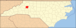 | |
| CDPs | ||
| Footnotes | ‡This populated place also has portions in an adjacent county or counties | |


|  | ||||||||||||
|
| |||||||||||||
| Authority control |
|
|---|