Clay Township, Owen County, Indiana
Clay Township is one of thirteen townships in Owen County, Indiana, United States. As of the 2010 census, its population was 2,600 and it contained 1,083 housing units.[1]
Clay Township | |
|---|---|
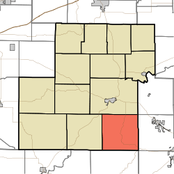 Location in Owen County | |
| Coordinates: 39°12′32″N 86°43′48″W | |
| Country | |
| State | |
| County | Owen |
| Government | |
| • Type | Indiana township |
| Area | |
| • Total | 36.02 sq mi (93.3 km2) |
| • Land | 36.02 sq mi (93.3 km2) |
| • Water | 0 sq mi (0 km2) 0% |
| Elevation | 745 ft (227 m) |
| Population (2010) | |
| • Total | 2,600 |
| • Density | 72.2/sq mi (27.9/km2) |
| ZIP codes | 47404, 47459, 47460 |
| GNIS feature ID | 453216 |
History
Clay Township was named for Kentucky statesman Henry Clay.[2]
The Ennis Archaeological Site was listed on the National Register of Historic Places in 1985.[3]
Geography
According to the 2010 census, the township has a total area of 36.02 square miles (93.3 km2), all land.[1]
Unincorporated towns
- Braysville at 39.211712°N 86.77445°W
- Freeman at 39.195323°N 86.733615°W
- Whitehall at 39.174213°N 86.684447°W
(This list is based on USGS data and may include former settlements.)
Cemeteries
The township contains five cemeteries: Brown, Gross, Hopewell, Livingston and Moreland.
School districts
- Spencer-Owen Community Schools
Political districts
- State House District 46
- State Senate District 39
References
- "Clay Township, Owen County, Indiana". Geographic Names Information System. United States Geological Survey. Retrieved 2009-10-23.
- United States Census Bureau 2009 TIGER/Line Shapefiles
- IndianaMap
- "Population, Housing Units, Area, and Density: 2010 - County -- County Subdivision and Place -- 2010 Census Summary File 1". United States Census. Archived from the original on 2020-02-12. Retrieved 2013-05-10.
- Blanchard, Charles (1884). Counties of Clay and Owen, Indiana: Historical and Biographical. F.A. Battey & Company. pp. 774.
- "National Register Information System". National Register of Historic Places. National Park Service. July 9, 2010.
External links
- Indiana Township Association
- United Township Association of Indiana
- City-Data.com page for Clay Township
Places adjacent to Clay Township, Owen County, Indiana | |
|---|---|
Municipalities and communities of Owen County, Indiana, United States | ||
|---|---|---|
| Towns | Map of Indiana highlighting Owen County | |
| Townships | ||
| Unincorporated communities |
| |
| Ghost town | ||
| Footnotes | ‡This populated place also has portions in an adjacent county or counties | |
This article is issued from Wikipedia. The text is licensed under Creative Commons - Attribution - Sharealike. Additional terms may apply for the media files.