Indiana State Road 235
State Road 235 in the U.S. state of Indiana is a short route in southwest Jackson County.
| ||||
|---|---|---|---|---|
 | ||||
| Route information | ||||
| Maintained by INDOT | ||||
| Length | 7.518 mi[1] (12.099 km) | |||
| Major junctions | ||||
| South end | ||||
| North end | ||||
| Highway system | ||||
| ||||

Route description
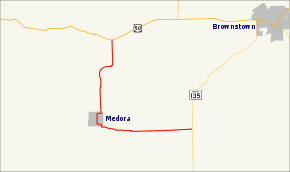
State Road 235 begins at State Road 135 east of Medora and southwest of Brownstown. The road travels west to Medora, which it reaches after about 3.5 miles (5.6 km). The Medora Covered Bridge parallels the road as it crosses the East Fork of the White River. Leaving Medora, the road travels north to U.S. Route 50.
History
SR 235 in the 1930s was originally part of US 50.
Major intersections
The entire route is in Jackson County.
| Location | mi[1] | km | Destinations | Notes | |
|---|---|---|---|---|---|
| Driftwood Township | 0.000 | 0.000 | Southern terminus of SR 235 | ||
| Owen Township | 7.518 | 12.099 | Northern terminus of SR 235 | ||
| 1.000 mi = 1.609 km; 1.000 km = 0.621 mi | |||||
References
- Indiana Department of Transportation (July 2015). Reference Post Book (PDF). Indianapolis: Indiana Department of Transportation. Retrieved October 8, 2015.
External links
This article is issued from Wikipedia. The text is licensed under Creative Commons - Attribution - Sharealike. Additional terms may apply for the media files.