List of United States National Historic Landmarks in United States commonwealths and territories, associated states, and foreign states
This is a list of National Historic Landmarks in U.S. commonwealths and territories, associated states, and foreign states.
Included are lists of National Historic Landmarks (NHLs) and of National Park Service administered areas in U.S. Commonwealths and territories, U.S.-associated states, and in the foreign state of Morocco. There are 23 NHLs in these areas.
NHLs in U.S. commonwealths and territories
| [1] | Landmark name | Image | Date designated[2] | Location | Commonwealth/Territory | Description |
|---|---|---|---|---|---|---|
| 1 | Blunts Point Battery | 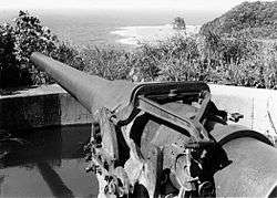 Blunts Point Battery |
May 28, 1987 (#73002128) |
Pago Pago 14°17′27″S 170°40′30″W |
American Samoa | A rare intact Pacific coastal battery, built as part of the fortification of the Samoan Islands after Pearl Harbor |
| 2 | Government House | 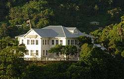 Government House |
December 14, 1990 (#72001443) |
Pago Pago 14°16′57″S 170°40′54″W |
American Samoa | A symbol of United States military and diplomatic relations throughout the South Pacific through World War I and World War II. Now the residence of the governor of American Samoa |
| 3 | World War II Facilities at Midway |  World War II Facilities at Midway |
May 28, 1987 (#87001302) |
Midway Atoll 28°12′N 177°21′W |
Midway Islands | Site of pivotal Battle of Midway which changed the balance of sea power during World War II |
| 4 | Landing Beaches; Aslito/Isley Field; & Marpi Point, Saipan Island | 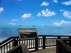 Landing Beaches; Aslito/Isley Field; & Marpi Point, Saipan Island |
February 4, 1985 (#85001789) |
Saipan 15°06′59″N 145°43′41″E |
Northern Mariana Islands | |
| 5 | Tinian Landing Beaches, Ushi Point & North Fields, Tinian Island | 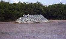 Tinian Landing Beaches, Ushi Point & North Fields, Tinian Island |
December 30, 1985 (#85003268) |
Tinian 15°04′54″N 145°37′57″E |
Northern Mariana Islands | |
| 6 | Antonio Lopez | 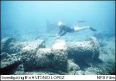 Antonio Lopez |
December 9, 1997 (#93001593) |
Dorado 18°28′48″N 66°13′50″W |
Puerto Rico | Shipwreck site |
| 7 | Caguana Site | 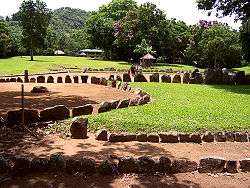 Caguana Site |
November 4, 1993 (#92001671) |
Utuado 18°17′49″N 66°46′55″W |
Puerto Rico | |
| 8 | Caparra Archaeological Site | 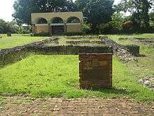 Caparra Archaeological Site |
April 19, 1994 (#84003155) |
Guaynabo 18°24′18″N 66°06′51″W |
Puerto Rico | |
| 9 | Casa Dra. Concha Melendez Ramirez | 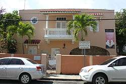 Casa Dra. Concha Melendez Ramirez |
February 27, 2013 (#11000414) |
San Juan 18°27′10″N 66°04′03″W |
Puerto Rico | The home of Dra. Concha Meléndez Ramírez, a writer and critic of the Generación del Treinta (Generation of 1930), a literary movement that shaped Puerto Rico's 20th-century national cultural identity. |
| 10 | La Fortaleza | 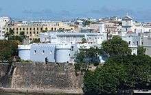 La Fortaleza |
October 9, 1960 (#66000951) |
San Juan 18°27′50″N 66°07′09″W |
Puerto Rico | |
| 11 | Old San Juan Historic District |  Old San Juan Historic District |
February 27, 2013 (#13000284) |
San Juan 18°26′44″N 66°04′33″W |
Puerto Rico | A well-preserved Spanish colonial city, nearly 400 years old. |
| 12 | Columbus Landing Site |  Columbus Landing Site |
October 9, 1960 (#66000743) |
Saint Croix 17°46′44″N 64°45′32″W |
Virgin Islands | |
| 13 | Fort Christian |  Fort Christian |
May 5, 1977 (#77001329) |
Saint Thomas 18°20′27″N 64°55′47″W |
Virgin Islands | |
| 14 | Fort Frederik | .jpg) Fort Frederik |
September 25, 1997 (#97001269) |
Saint Croix 17°42′55″N 64°53′00″W |
Virgin Islands | |
| 15 | St. Thomas Synagogue | .jpg) St. Thomas Synagogue |
September 25, 1997 (#97001270) |
Saint Thomas 18°20′41″N 64°55′59″W |
Virgin Islands | |
| 16 | Blackbeard's Castle (Skytsborg) | 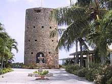 Blackbeard's Castle (Skytsborg) |
October 12, 1994 (#91001844) |
Saint Thomas 18°20′38″N 64°55′47″W |
Virgin Islands | |
| 17 | Wake Island | 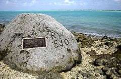 Wake Island |
September 16, 1985 (#85002726) |
Wake Island 19°18′00″N 166°38′00″E |
Wake Island |
NHLs in Associated States
This is a complete list of the five National Historic Landmarks in sovereign states that are in free association with the United States.
| [1] | Landmark name | Image | Date designated[2] | Location | State | Description |
|---|---|---|---|---|---|---|
| 1 | Kwajalein Island Battlefield | 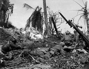 Kwajalein Island Battlefield |
February 4, 1985 (#85001757) |
Kwajalein 8°43′00″N 167°44′00″E |
Marshall Islands | This district encompasses the entire 1944 bounds of Kwajalein Island, commemorating its role in the 1944 Battle of Kwajalein. |
| 2 | Roi-Namur | 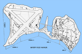 Roi-Namur |
February 4, 1985 (#85001758) |
Kwajalein 9°23′46″N 167°28′33″E |
Marshall Islands | This district encompasses all of Roi-Namur island, commemorating its role in the 1944 Battle of Kwajalein. |
| 3 | Nan Madol | 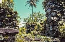 Nan Madol |
September 16, 1985 (#74002226) |
Pohnpei 6°50′31″N 158°19′56″E |
Federated States of Micronesia | |
| 4 | Truk Lagoon Underwater Fleet, Truk Atoll | 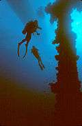 Truk Lagoon Underwater Fleet, Truk Atoll |
February 4, 1985 (#76002267) |
Chuuk 7°25′00″N 151°47′00″E |
Federated States of Micronesia | |
| 5 | Peleliu Battlefield | 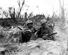 Peleliu Battlefield |
February 4, 1985 (#85001754) |
Peleliu 7°00′01″N 134°13′23″E |
Palau |
U.S. NHLs in foreign states
| [1] | Landmark name | Image | Date designated[2] | Location | State | Description |
|---|---|---|---|---|---|---|
| 1 | American Legation |  American Legation |
December 17, 1982 (#81000703) |
Tangier 35°47′17″N 5°48′32″E |
Morocco | The first property on foreign soil owned by the US government. |
National Park Service Areas in U.S. Commonwealths and Territories
Also of historical interest are:
- Christiansted National Historic Site, in U.S. Virgin Islands
- Salt River Bay National Historical Park and Ecological Preserve, in U.S. Virgin Islands (also an NHL, listed above as Columbus Landing Site)
- San Juan National Historic Site, in Puerto Rico
Other National Park Service-administered areas in U.S. commonwealths and territories are:
- Buck Island Reef National Monument, in U.S. Virgin Islands
- National Park of American Samoa, in American Samoa
- Virgin Islands Coral Reef National Monument, in U.S. Virgin Islands
- Virgin Islands National Park, in U.S. Virgin Islands
A former US National Historical Site is St. Thomas National Historic Site, transferred to Virgin Islands.
See also
- List of National Historic Landmarks by state
- National Register of Historic Places listings in American Samoa
- National Register of Historic Places listings in Palau
- National Register of Historic Places listings in Puerto Rico
- National Register of Historic Places listings in the Federated States of Micronesia
- National Register of Historic Places listings in the Marshall Islands
- National Register of Historic Places listings in the Northern Mariana Islands
- National Register of Historic Places listings in the United States Virgin Islands
References
- Numbers represent an ordering by significant words. Various colorings, defined here, differentiate National Historic Landmarks and historic districts from other NRHP buildings, structures, sites or objects.
- The eight-digit number below each date is the number assigned to each location in the National Register Information System database, which can be viewed by clicking the number.
External links
| Wikimedia Commons has media related to |
- List of National Historic Landmarks by State
- National Historic Landmarks Program, at National Park Service
| Topics | |
|---|---|
| Lists by state |
|
| Lists by insular areas | |
| Lists by associated state | |
| Other areas | |
| Related | |
| |
This article is issued from Wikipedia. The text is licensed under Creative Commons - Attribution - Sharealike. Additional terms may apply for the media files.