Newton Grove, North Carolina
Newton Grove, chartered in 1879, is a town in Sampson County, North Carolina, United States. The population was 569 as of the 2010 census.
Newton Grove, North Carolina | |
|---|---|
| Nickname(s): Circle City | |
| Motto(s): "Circle of Opportunity" | |
 Newton Grove, North Carolina Location within the state of North Carolina | |
| Coordinates: 35°14′48″N 78°21′25″W | |
| Country | United States |
| State | North Carolina |
| County | Sampson |
| Area | |
| • Total | 3.1 sq mi (8.0 km2) |
| • Land | 3.1 sq mi (8.0 km2) |
| • Water | 0.0 sq mi (0.0 km2) |
| Elevation | 180 ft (55 m) |
| Population (2010) | |
| • Total | 569 |
| • Estimate (2018)[1] | 565 |
| • Density | 180/sq mi (71/km2) |
| Time zone | UTC-5 (Eastern (EST)) |
| • Summer (DST) | UTC-4 (EDT) |
| ZIP code | 28366 |
| Area code(s) | 910 |
| FIPS code | 37-47020[2] |
| GNIS feature ID | 1025580[3] |
| Website | http://www.newtongrove.net/ |
History
Thirteen Oaks and the Isaac Williams House are listed on the National Register of Historic Places.[4]
Geography
Newton Grove is located at 35°14′48″N 78°21′25″W (35.246764, -78.357024).[5]
According to the United States Census Bureau, the town has a total area of 3.1 square miles (8.0 km2).3.1 square miles (8.0 km²) of it is land and 0.04 square miles (0.10 km2) of it (0.65%) is water.
There is a large, six-way roundabout in the center of town, with a hexagonal loop road around it, named circle street, contrary to its shape.
Demographics
| Historical population | |||
|---|---|---|---|
| Census | Pop. | %± | |
| 1880 | 61 | — | |
| 1890 | 63 | 3.3% | |
| 1900 | 75 | 19.0% | |
| 1910 | 73 | −2.7% | |
| 1920 | 125 | 71.2% | |
| 1930 | 150 | 20.0% | |
| 1940 | 339 | 126.0% | |
| 1950 | 374 | 10.3% | |
| 1960 | 477 | 27.5% | |
| 1970 | 546 | 14.5% | |
| 1980 | 564 | 3.3% | |
| 1990 | 511 | −9.4% | |
| 2000 | 606 | 18.6% | |
| 2010 | 569 | −6.1% | |
| Est. 2018 | 565 | [1] | −0.7% |
| U.S. Decennial Census[6] | |||
At the 2000 census there were 606 people, 223 households, and 152 families in the town. The population density was 197.2 people per square mile (76.2/km²). There were 240 housing units at an average density of 78.1 per square mile (30.2/km²). The racial makeup of the town was 77.72% White, 11.39% African American, 0.50% Native American, 0.17% Asian, 8.75% from other races, and 1.49% from two or more races. Hispanic or Latino of any race were 14.19%.[2]
Of the 223 households 26.0% had children under the age of 18 living with them, 54.3% were married couples living together, 11.2% had a female householder with no husband present, and 31.8% were non-families. 30.0% of households were one person and 14.3% were one person aged 65 or older. The average household size was 2.55 and the average family size was 3.15.
The age distribution was 20.6% under the age of 18, 9.6% from 18 to 24, 25.4% from 25 to 44, 21.8% from 45 to 64, and 22.6% 65 or older. The median age was 42 years. For every 100 females, there were 85.3 males. For every 100 females age 18 and over, there were 82.9 males.
The median household income was $35,000 and the median family income was $51,250. Males had a median income of $31,667 versus $37,750 for females. The per capita income for the town was $19,295. About 7.0% of families and 11.1% of the population were below the poverty line, including 10.3% of those under age 18 and 14.3% of those age 65 or over.
Education
Newton Grove is home to Hobbton High School, a small 1A division school established in 1957.[7]
References
- "Population and Housing Unit Estimates". Retrieved Oct 11, 2019.
- "U.S. Census website". United States Census Bureau. Retrieved 2008-01-31.
- "US Board on Geographic Names". United States Geological Survey. 2007-10-25. Retrieved 2008-01-31.
- "National Register Information System". National Register of Historic Places. National Park Service. July 9, 2010.
- "US Gazetteer files: 2010, 2000, and 1990". United States Census Bureau. 2011-02-12. Retrieved 2011-04-23.
- "Census of Population and Housing". Census.gov. Retrieved June 4, 2015.
- "Hobbton High School". Sampson County Schools. Retrieved 31 December 2016.
Municipalities and communities of Sampson County, North Carolina, United States | ||
|---|---|---|
| City | 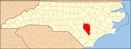 | |
| Towns | ||
| CDPs | ||
| Unincorporated communities | ||
| Footnotes | ‡This populated place also has portions in an adjacent county or counties | |
| Authority control |
|
|---|