Ball Ground, Georgia
Ball Ground is a city in Cherokee County, Georgia, United States. Settled many years before being incorporated on January 1, 1882, the 2010 census shows the city had a population of 1,433, nearly doubling between 2000 and 2010.[6]
Ball Ground, Georgia | |
|---|---|
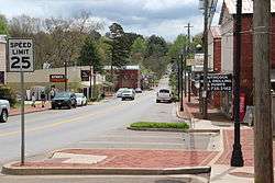 Ball Ground Historic District | |
| Motto(s): “Where we roll out the red carpet, not the red tape"[1] | |
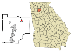 Location in Cherokee County and the state of Georgia | |
 Ball Ground, Georgia Location in Cherokee County and the state of Georgia  Ball Ground, Georgia Ball Ground, Georgia (the United States) | |
| Coordinates: 34°20′14″N 84°22′42″W | |
| Country | United States |
| State | Georgia |
| County | Cherokee |
| Area | |
| • Total | 6.41 sq mi (16.59 km2) |
| • Land | 6.37 sq mi (16.50 km2) |
| • Water | 0.04 sq mi (0.10 km2) |
| Elevation | 1,102 ft (336 m) |
| Population (2010) | |
| • Total | 1,433 |
| • Estimate (2018)[3] | 2,119 |
| • Density | 332.65/sq mi (128.45/km2) |
| Time zone | UTC-5 (Eastern (EST)) |
| • Summer (DST) | UTC-4 (EDT) |
| ZIP code | 30107 |
| Area code(s) | 770/678/470 |
| FIPS code | 13-05036[4] |
| GNIS feature ID | 0354443[5] |
| Website | cityofballground |
History
The town developed near the ball grounds, or fields where the Cherokee people used to play stick ball, a rough game similar to modern lacrosse.[7] The large fields and abundance of freshwater streams made Ball Ground attractive for large gatherings of the Cherokee. In 1755, it was the site of the decisive Battle of Taliwa between the Cherokee and Muscogee Creek peoples; the Cherokee won.[7]
After Indian Removal in the late 1830s, the region began to fill with European-American settlers, some of whom used enslaved African Americans as laborers. The Civil War interrupted development; by the late 19th century, the community had two country stores and a few dwellings, and was surrounded by farms. Construction of railroads in the post-Civil War period, brought new businesses to the region. The community was incorporated on January 1, 1882, the same year that the Louisville & Nashville Railroad came through, to serve the marble industry.[8][9]
In 1985, the Alfred W. Roberts House was listed on the National Register of Historic Places. It is the only house in Cherokee County that has this recognition.[10]
On December 4, 2009, the Ball Ground Historic District was listed on the NRHP, for its significance to Native American and early national history.[11]
On September 5, 2011, Tropical Storm Lee, an EF1 tornado, caused damage throughout the city's business and residential areas.[12] No deaths or serious injuries were reported. Striking much of Cherokee County, including Woodstock, Holly Springs and Canton, the storms cut a 24-mile (39 km) path. Electricity was restored after two days, and residents continued clean-up for numerous days.
In May 2015, Universal Alloy Corporation announced it was building a new factory in Ball Ground.[13] The facility opened in 2017. Universal Alloy (UAC) is one of the largest employers in Cherokee County.
City government
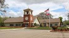
The city of Ball Ground is governed by a council-mayor form of government. The five council members and mayor are each elected to four-year terms by city residents, although there are no term limits. The city is divided into five posts, with one council member elected to serve each post, even though these elections are conducted "at-large". The mayor is also elected at-large. Although the Mayor typically has no vote in most matters, the position holds strong executive power and casts tie breaking votes when needed. The Mayor and Council hold the monthly council meetings on the second Thursday of each month at 7:00 p.m. All meetings of the City Government Manager and Council are held in the Council Chambers of City Hall located at 215 Valley Street.
Geography
Ball Ground is located in northeastern Cherokee County, just north of Canton and south of Nelson. Ball Ground is along Interstate 575, with access from Exit 27, 4 miles (6 km) south of the highway's northern terminus, and 48 miles (77 km) north of Atlanta.
According to the United States Census Bureau, the city has a total area of 5.8 square miles (15.1 km2), of which 0.031 square miles (0.08 km2), or 0.50%, is water.[6] The city's elevation averages around 1,100 feet (340 m) above sea level, ranging from just over 1,000 feet (300 m) in the valleys to around 1,200 feet (370 m) on several hilltops within the city.
Neighboring communities
- Nelson (north)
- Canton (southwest)
- Keithsburg (southwest)
- Free Home (south)
Demographics
| Historical population | |||
|---|---|---|---|
| Census | Pop. | %± | |
| 1890 | 296 | — | |
| 1900 | 302 | 2.0% | |
| 1910 | 443 | 46.7% | |
| 1920 | 809 | 82.6% | |
| 1930 | 706 | −12.7% | |
| 1940 | 711 | 0.7% | |
| 1950 | 700 | −1.5% | |
| 1960 | 707 | 1.0% | |
| 1970 | 617 | −12.7% | |
| 1980 | 640 | 3.7% | |
| 1990 | 905 | 41.4% | |
| 2000 | 730 | −19.3% | |
| 2010 | 1,433 | 96.3% | |
| Est. 2018 | 2,119 | [3] | 47.9% |
| U.S. Decennial Census[14] | |||
As of the census of 2010,[4] there were 1,433 people, 601 households, and 532 families residing in the city. The population density was 589.1 people per square mile (227.3/km²). There were 601 housing units at an average density of 92.8 persons/km² (240.5 persons/sq mi). The racial makeup of the city was 97.4% White, 0.7% African American, and 0.3% Asian. Hispanic or Latino of any race were 1.5% of the population.
There were 601 households out of which 33.1% had children under the age of 18 living with them, 64.3% were married couples living together, 9.3% had a female householder with no husband present, and 23.0% were non-families. 20.1% of all households were made up of individuals, and 10.8% had someone living alone who was 65 years of age or older. The average household size was 2.71 and the average family size was 2.69.
In the city, the population was spread out with 27.3% under the age of 18, 6.2% from 18 to 24, 29.3% from 25 to 44, 25.8% from 45 to 64, and 11.5% who were 65 years of age or older. The median age was 36 years. For every 100 females, there were 108.6 males. For every 100 females age 18 and over, there were 97.4 males.
The median income for a household in the city was $45,875, and the median income for a family was $51,429. Males had a median income of $39,125 versus $27,361 for females. The per capita income for the city was $18,147. About 6.7% of families and 12.2% of the population were below the poverty line, including 20.2% of those under age 18 and 12.5% of those age 65 or over.
Average house value in Ball Ground area was $157,923.22. Average yearly wages paid by businesses in Ball Ground area was $31,227.00. Average number of people employed by businesses in Ball Ground area was 10.1.[15]
Education
Education in Ball Ground is run by the Cherokee County government and the Georgia state government. Ball Ground's elementary aged children are served by the Ball Ground Elementary School STEM Academy.[16]
Economy
In the 21st century, Ball Ground is growing as businesses and homeowners are pushing into the North Georgia mountains along the I-575 corridor. It boasts a number of new subdivisions and light industry.
Transportation
The Cherokee County Airport is located between Ball Ground and Canton.
Interstate 575 goes through Cobb and Cherokee counties, skirting the west edge of Ball Ground, ending just north of Ball Ground. Georgia State Route 5 (Ball Ground highway) runs parallel and just to the east of I-575, into Ball Ground from the southwest. Georgia State Route 372 (Ball Ground Rd) runs through Ball Ground from the southeast, through the center of town, northward, merging at the terminus of I-575 to become Georgia State Route 515 northward.
References
- "City of Ball Ground Georgia Website". City of Ball Ground Georgia Website. Retrieved September 6, 2012.
- "2018 U.S. Gazetteer Files". United States Census Bureau. Retrieved Feb 12, 2020.
- "Population and Housing Unit Estimates". Retrieved June 4, 2019.
- "U.S. Census website". United States Census Bureau. Retrieved 2008-01-31.
- "US Board on Geographic Names". United States Geological Survey. 2007-10-25. Retrieved 2008-01-31.
- "Geographic Identifiers: 2010 Demographic Profile Data (G001): Ball Ground city, Georgia". U.S. Census Bureau, American Factfinder. Archived from the original on February 12, 2020. Retrieved July 24, 2014.
- "Ball Ground". Georgia.gov. GeorgiaGov. Retrieved August 31, 2018.
- "Ball Ground". GeorgiaGov. Retrieved September 6, 2012.
- "First Hundred Years". City of Ball Ground.com. Retrieved August 30, 2018.
- "2017 Cultivating Cherokee" (PDF). Cherokee Chamber of Commerce. 2017. Retrieved July 30, 2018.
- "Ball Ground Historic". RockBarn.org. Retrieved August 28, 2018.
- "Tornado Touches Down in Cherokee County". WSB-TV. Archived from the original on February 10, 2013. Retrieved September 7, 2011.
- Dixon, Kristol (May 21, 2015). "Universal Alloy Corporation Purchases Land For Expansion". Canton Patch. Retrieved July 30, 2018.
- "Census of Population and Housing". Census.gov. Retrieved June 4, 2015.
- Ball Ground in Cherokee County, GA
- "Ball Ground Elementary School STEM Academy". CherokeeK12.net. Retrieved August 28, 2018.
External links
| Wikimedia Commons has media related to Ball Ground, Georgia. |
- City of Ball Ground official website
- Ball Ground at City-Data.com
Municipalities and communities of Cherokee County, Georgia, United States | ||
|---|---|---|
| Cities | 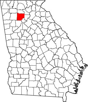 Map of Georgia highlighting Cherokee County | |
| Unincorporated communities | ||
| Footnotes | ‡This populated place also has portions in an adjacent county or counties | |
