Mitchell County, Georgia
Mitchell County is a county in the U.S. state of Georgia. As of the 2010 census, the population was 23,498.[1] The county seat is Camilla.[2] Mitchell County was created on December 21, 1857.[3]
Mitchell County | |
|---|---|
.JPG) Mitchell County Courthouse (Built 1936), Camilla | |
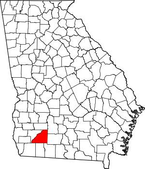 Location within the U.S. state of Georgia | |
 Georgia's location within the U.S. | |
| Coordinates: 31°13′N 84°11′W | |
| Country | |
| State | |
| Founded | 1857 |
| Seat | Camilla |
| Largest city | Camilla |
| Area | |
| • Total | 514 sq mi (1,330 km2) |
| • Land | 512 sq mi (1,330 km2) |
| • Water | 1.7 sq mi (4 km2) 0.3%% |
| Population | |
| • Estimate (2018) | 22,192 |
| • Density | 46/sq mi (18/km2) |
| Time zone | UTC−5 (Eastern) |
| • Summer (DST) | UTC−4 (EDT) |
| Congressional district | 2nd |
| Website | www |
History
Mitchell County was created out of Baker County on December 21, 1857. It is the state's 123rd county.[4]
Name origin
Sources conflict as to whether Mitchell County was named for David Brydie Mitchell, the 27th Governor of Georgia, or for Henry Mitchell, a general in the Revolutionary War.[5] However, it is most likely that the county was named for General Henry Mitchell, as a marker outside of the Mitchell County Courthouse states that "However, the Georgia Laws of 1857 (pages 38-40), creating Mitchell County, say the county was named in honor of Gen. Henry Mitchell...."[6]
Geography
According to the U.S. Census Bureau, the county has a total area of 514 square miles (1,330 km2), of which 512 square miles (1,330 km2) is land and 1.7 square miles (4.4 km2) (0.3%) is water.[7]
The bulk of Mitchell County is located in the Lower Flint River sub-basin of the ACF River Basin (Apalachicola-Chattahoochee-Flint River Basin). The county's southeastern corner, bordered by a line from Sale City southwest through Pelham, is located in the Lower Ochlockonee River sub-basin of the same Ochlockonee River basin.[8]
Major highways
Adjacent counties
- Dougherty County (north)
- Worth County (northeast)
- Colquitt County (east)
- Thomas County (southeast)
- Grady County (south)
- Decatur County (southwest)
- Baker County (west)
Government
The County Commission meets the second Tuesday of each month at 7 pm.
| Board of Commissioners | ||
|---|---|---|
| District | Commissioner | Party |
| District 1 (At-Large) | Benjamin Hayward, Chairman of Board | Democratic |
| District 2 | Keith Jones | |
| District 3 | Reggie Bostick | Vice Chairman |
| District 4 | Julius Hatcher | |
| District 5 | David Sullivan | |
Demographics
| Historical population | |||
|---|---|---|---|
| Census | Pop. | %± | |
| 1860 | 4,308 | — | |
| 1870 | 6,633 | 54.0% | |
| 1880 | 9,392 | 41.6% | |
| 1890 | 10,906 | 16.1% | |
| 1900 | 14,767 | 35.4% | |
| 1910 | 22,114 | 49.8% | |
| 1920 | 25,588 | 15.7% | |
| 1930 | 23,620 | −7.7% | |
| 1940 | 23,261 | −1.5% | |
| 1950 | 22,528 | −3.2% | |
| 1960 | 19,652 | −12.8% | |
| 1970 | 18,956 | −3.5% | |
| 1980 | 21,114 | 11.4% | |
| 1990 | 20,275 | −4.0% | |
| 2000 | 23,932 | 18.0% | |
| 2010 | 23,498 | −1.8% | |
| Est. 2018 | 22,192 | [9] | −5.6% |
| U.S. Decennial Census[10] 1790-1960[11] 1900-1990[12] 1990-2000[13] 2010-2013[1] | |||
2000 census
As of the census[14] of 2000, there were 23,932 people, 8,063 households, and 5,934 families living in the county. The population density was 18/km² (47/mi²). There were 8,880 housing units at an average density of 7/km² (17/mi²). The racial makeup of the county was 49.57% White, 47.86% Black or African American, 0.20% Native American, 0.27% Asian, 0.05% Pacific Islander, 1.34% from other races, and 0.70% from two or more races. 2.05% of the population were Hispanic or Latino of any race.
There were 8,063 households, out of which 34.40% had children younger than 18 living with them, 46.60% were married couples living together, 22.50% had a female householder with no husband present and 26.40% were non-families. 23.30% of all households were made up of individuals and 9.50% had someone living alone who was 65 older. The average household size was 2.72, and the average family size was 3.19.
In the county, the population was spread out with 27.30% younger than 18, 9.90% from 18 to 24, 29.40% from 25 to 44, 21.60% from 45 to 64, and 11.70% who were 65 older. The median age was 34 years. For every 100 females, there were 103.50 males. For every 100 females 18 and older, there were 101.00 males.
The median income for a household in the county was $26,581, and the median income for a family was $31,262. Males had a median income of $25,130 vs. $19,582 for females. The per capita income for the county was $13,042. About 22.30% of families and 26.40% of the population were below the poverty line, including 38.50% of those younger than 18 and 20.30% of those 65 or oler.
2010 census
As of the 2010 United States Census, there were 23,498 people, 8,055 households, and 5,761 families living in the county.[15] The population density was 45.9 inhabitants per square mile (17.7/km2). There were 8,996 housing units at an average density of 17.6 per square mile (6.8/km2).[16] The racial makeup of the county was 47.9% white, 47.7% black or African American, 0.5% Asian, 0.3% American Indian, 2.4% from other races, and 1.0% from two or more races. Those of Hispanic or Latino origin made up 4.4% of the population.[15] In terms of ancestry, 13.0% were American, 5.8% were Irish, and 5.2% were English.[17]
Of the 8,055 households, 37.0% had children under the age of 18 living with them, 43.0% were married couples living together, 23.2% had a female householder with no husband present, 28.5% were non-families, and 25.0% of all households were made up of individuals. The average household size was 2.65 and the average family size was 3.15. The median age was 37.1 years.[15]
The median income for a household in the county was $36,198 and the median income for a family was $43,930. Males had a median income of $36,272 versus $25,243 for females. The per capita income for the county was $16,322. About 16.4% of families and 22.2% of the population were below the poverty line, including 28.9% of those under age 18 and 13.2% of those age 65 or over.[18]
Education
The Mitchell County School District operates public schools.
Higher Education
Andersonville Theological Seminary has its headquarters based in Camilla. The seminary's headquarters consists of two administrative buildings. Most of the seminary's students take online classes to complete their degree programs, but in January 2020 the school started to provide on-site courses at their location in Camilla.[19]
Communities
Cities
- Baconton
- Camilla
- Meigs (partly in Thomas County)
- Pelham
Town
Unincorporated communities
Politics
| Year | Republican | Democratic | Third parties |
|---|---|---|---|
| 2016 | 54.3% 4,279 | 44.3% 3,493 | 1.4% 108 |
| 2012 | 50.2% 4,155 | 49.3% 4,081 | 0.5% 45 |
| 2008 | 51.7% 4,201 | 47.6% 3,872 | 0.7% 59 |
| 2004 | 53.4% 3,885 | 46.2% 3,360 | 0.4% 27 |
| 2000 | 48.1% 2,790 | 51.2% 2,971 | 0.7% 38 |
| 1996 | 36.4% 2,033 | 56.7% 3,165 | 7.0% 388 |
| 1992 | 33.1% 1,917 | 52.7% 3,052 | 14.3% 826 |
| 1988 | 53.3% 2,590 | 46.5% 2,260 | 0.2% 10 |
| 1984 | 49.5% 2,737 | 50.5% 2,791 | |
| 1980 | 38.1% 2,231 | 60.9% 3,566 | 1.0% 59 |
| 1976 | 25.9% 1,572 | 74.1% 4,495 | |
| 1972 | 68.2% 2,400 | 31.8% 1,120 | |
| 1968 | 13.0% 731 | 22.3% 1256 | 64.7% 3,647 |
| 1964 | 73.2% 3,265 | 26.8% 1,197 | |
| 1960 | 11.6% 430 | 88.4% 3,264 | |
| 1956 | 12.3% 382 | 87.7% 2,735 | |
| 1952 | 16.4% 601 | 83.6% 3,054 | |
| 1948 | 22.1% 457 | 70.3% 1,453 | 7.6% 157 |
| 1944 | 9.4% 226 | 90.6% 2,179 | |
| 1940 | 6.8% 155 | 93.2% 2,131 | |
| 1936 | 3.3% 79 | 96.5% 2,297 | 0.2% 5 |
| 1932 | 0.7% 15 | 99.1% 2,097 | 0.2% 5 |
| 1928 | 9.5% 143 | 90.5% 1,358 | |
| 1924 | 6.1% 51 | 87.8% 736 | 6.1% 51 |
| 1920 | 13.4% 144 | 86.6% 930 | |
| 1916 | 9.1% 96 | 87.1% 921 | 3.9% 41 |
| 1912 | 12.5% 150 | 87.5% 1,046 |
Notable people
- George Thornewell Smith - former Lieutenant Governor of Georgia and state court judge
References
- "State & County QuickFacts". United States Census Bureau. Archived from the original on June 7, 2011. Retrieved February 16, 2014.
- "Find a County". National Association of Counties. Retrieved June 7, 2011.
- Krakow, Kenneth K. (1975). Georgia Place-Names: Their History and Origins (PDF). Macon, GA: Winship Press. p. 149. ISBN 0-915430-00-2.
- https://georgiainfo.galileo.usg.edu/topics/counties/mitchell. Missing or empty
|title=(help) - "New Georgia Encyclopedia".
It was named either for Henry Mitchell, a general in the Revolutionary War (1775-83), or for David B. Mitchell, who served twice as Georgia's governor in the early 1800s; historical sources differ.
- "University of North Florida Digital Commons".
Some historians say that the county was named for David B. Mitchell, Governor of Georgia in 1809-13 and again in 1815-17, and that Camilla was named for daughter. However, the Georgia Laws of 1857 (pages 38-40), creating Mitchell County, say the county was named in honor of Gen. Henry Mitchell, who was born in 1760 and died in 1839
- "US Gazetteer files: 2010, 2000, and 1990". United States Census Bureau. February 12, 2011. Retrieved April 23, 2011.
- "Georgia Soil and Water Conservation Commission Interactive Mapping Experience". Georgia Soil and Water Conservation Commission. Retrieved November 24, 2015.
- "Population and Housing Unit Estimates". Retrieved July 31, 2019.
- "U.S. Decennial Census". United States Census Bureau. Retrieved June 24, 2014.
- "Historical Census Browser". University of Virginia Library. Retrieved June 24, 2014.
- "Population of Counties by Decennial Census: 1900 to 1990". United States Census Bureau. Retrieved June 24, 2014.
- "Census 2000 PHC-T-4. Ranking Tables for Counties: 1990 and 2000" (PDF). United States Census Bureau. Retrieved June 24, 2014.
- "U.S. Census website". United States Census Bureau. Retrieved May 14, 2011.
- "DP-1 Profile of General Population and Housing Characteristics: 2010 Demographic Profile Data". United States Census Bureau. Archived from the original on February 13, 2020. Retrieved December 30, 2015.
- "Population, Housing Units, Area, and Density: 2010 - County". United States Census Bureau. Archived from the original on February 13, 2020. Retrieved December 30, 2015.
- "DP02 SELECTED SOCIAL CHARACTERISTICS IN THE UNITED STATES – 2006-2010 American Community Survey 5-Year Estimates". United States Census Bureau. Archived from the original on February 13, 2020. Retrieved December 30, 2015.
- "DP03 SELECTED ECONOMIC CHARACTERISTICS – 2006-2010 American Community Survey 5-Year Estimates". United States Census Bureau. Archived from the original on February 13, 2020. Retrieved December 30, 2015.
- ATS. "Intent to Attend 2020 Module Form" (PDF). Andersonville Theological Seminary. Retrieved July 7, 2019.
- Leip, David. "Dave Leip's Atlas of U.S. Presidential Elections". uselectionatlas.org. Retrieved March 22, 2018.
Places adjacent to Mitchell County, Georgia | ||||||||||
|---|---|---|---|---|---|---|---|---|---|---|
| ||||||||||
Municipalities and communities of Mitchell County, Georgia, United States | ||
|---|---|---|
| Cities | Map of Georgia highlighting Mitchell County | |
| Town | ||
| Unincorporated communities | ||
| Footnotes | ‡This populated place also has portions in an adjacent county or counties | |

| Authority control |
|
|---|