Oglethorpe County, Georgia
Oglethorpe County is a county located in the northeastern part of the U.S. state of Georgia. As of the 2010 census, the population was 14,899.[1] The county seat is Lexington.[2]
Oglethorpe County | |
|---|---|
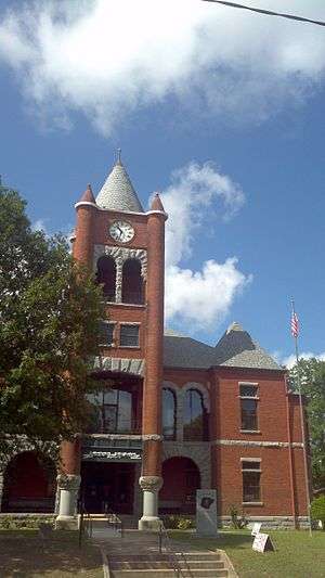 Oglethorpe County Courthouse | |
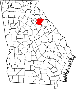 Location within the U.S. state of Georgia | |
 Georgia's location within the U.S. | |
| Coordinates: 33°53′N 83°05′W | |
| Country | |
| State | |
| Founded | December 19, 1795 |
| Named for | James Oglethorpe |
| Seat | Lexington |
| Largest city | Crawford |
| Area | |
| • Total | 442 sq mi (1,140 km2) |
| • Land | 439 sq mi (1,140 km2) |
| • Water | 3.0 sq mi (8 km2) 0.7%% |
| Population | |
| • Estimate (2018) | 15,054 |
| • Density | 34/sq mi (13/km2) |
| Time zone | UTC−5 (Eastern) |
| • Summer (DST) | UTC−4 (EDT) |
| Congressional district | 10th |
Oglethorpe County is included in the Athens-Clarke County, GA Metropolitan Statistical Area, which is also included in the Atlanta-Athens-Clarke County-Sandy Springs, GA Combined Statistical Area. It is the largest county in Northeast Georgia.
History
Oglethorpe County was originally part of a large tract of land surrendered by Creek and Cherokee Native Americans to the Colony of Georgia in the treaty of 1773. The county itself was founded on December 19, 1793, and is named for Georgia's founder, General James Oglethorpe. On September 10, 1919, Obe Cox was accused of murdering a white farmer's wife. He was seized by a white mob taken to the scene of the crime, his body riddled with bullets and burned at the stake. Several thousand persons witnessed the scene. The lynching was controversial as the local Black community "thanked" the mob for just killing Cox and not attacking their community.[3] After an investigation the Black media of the time reported that the Blacks who wrote the letter thanking the lynching "do not stand for much in the town and are excused for their utter ignorance in condoning [lynching]."[3]
Geography
According to the U.S. Census Bureau, the county has a total area of 442 square miles (1,140 km2), of which 439 square miles (1,140 km2) is land and 3.0 square miles (7.8 km2) (0.7%) is water.[4] The county is located in the Piedmont region of the state.
The majority of Oglethorpe County is located in the Broad River sub-basin of the Savannah River basin. A narrow western portion of the county, in a line from just north of Woodville, through Crawford, to just south of Winterville, is located in the Upper Oconee River sub-basin of the Altamaha River basin. A small part of the southern portion of the county, from Maxeys east, is located in the Little River sub-basin of the Savannah River basin.[5]
River
Adjacent counties
- Elbert County (northeast)
- Wilkes County (east)
- Taliaferro County (southeast)
- Greene County (south)
- Oconee County (west)
- Clarke County (west)
- Madison County (north)
National protected area
- Oconee National Forest (part)
- Watson Mill Bridge State Park (part)
Transportation
Major highways
Pedestrians and cycling
The county has limited walkability options available.
Demographics
| Historical population | |||
|---|---|---|---|
| Census | Pop. | %± | |
| 1800 | 9,780 | — | |
| 1810 | 12,297 | 25.7% | |
| 1820 | 14,046 | 14.2% | |
| 1830 | 13,618 | −3.0% | |
| 1840 | 10,868 | −20.2% | |
| 1850 | 12,259 | 12.8% | |
| 1860 | 11,549 | −5.8% | |
| 1870 | 11,782 | 2.0% | |
| 1880 | 15,400 | 30.7% | |
| 1890 | 16,951 | 10.1% | |
| 1900 | 17,881 | 5.5% | |
| 1910 | 18,680 | 4.5% | |
| 1920 | 20,287 | 8.6% | |
| 1930 | 12,927 | −36.3% | |
| 1940 | 12,430 | −3.8% | |
| 1950 | 9,958 | −19.9% | |
| 1960 | 7,926 | −20.4% | |
| 1970 | 7,598 | −4.1% | |
| 1980 | 8,929 | 17.5% | |
| 1990 | 9,763 | 9.3% | |
| 2000 | 12,635 | 29.4% | |
| 2010 | 14,899 | 17.9% | |
| Est. 2018 | 15,054 | [6] | 1.0% |
| U.S. Decennial Census[7] 1790-1960[8] 1900-1990[9] 1990-2000[10] 2010-2013[1] | |||
2000 census
As of the census[11] of 2000, there were 12,635 people, 4,849 households, and 3,539 families living in the county. The population density was 11/km² (29/mi²). There were 5,368 housing units at an average density of 5/km² (12/mi²). The racial makeup of the county was 78.29% White, 19.75% Black or African American, 0.20% Native American, 0.25% Asian, 0.04% Pacific Islander, 0.63% from other races, and 0.85% from two or more races. 1.38% of the population were Hispanic or Latino of any race.
There were 4,849 households out of which 33.60% had children under the age of 18 living with them, 57.30% were married couples living together, 11.50% had a female householder with no husband present, and 27.00% were non-families. 23.00% of all households were made up of individuals and 9.00% had someone living alone who was 65 years of age or older. The average household size was 2.58 and the average family size was 3.05.
In the county, the population was spread out with 25.80% under the age of 18, 7.80% from 18 to 24, 30.00% from 25 to 44, 24.00% from 45 to 64, and 12.40% who were 65 years of age or older. The median age was 37 years. For every 100 females, there were 94.40 males. For every 100 females age 18 and over, there were 92.30 males.
The median income for a household in the county was $35,578, and the median income for a family was $41,443. Males had a median income of $30,733 versus $22,289 for females. The per capita income for the county was $17,089. About 10.00% of families and 13.20% of the population were below the poverty line, including 15.90% of those under age 18 and 18.40% of those age 65 or over.
2010 census
As of the 2010 United States Census, there were 14,899 people, 5,647 households, and 4,070 families living in the county.[12] The population density was 33.9 inhabitants per square mile (13.1/km2). There were 6,484 housing units at an average density of 14.8 per square mile (5.7/km2).[13] The racial makeup of the county was 78.3% white, 17.2% black or African American, 0.4% Asian, 0.2% American Indian, 1.9% from other races, and 1.9% from two or more races. Those of Hispanic or Latino origin made up 3.7% of the population.[12] In terms of ancestry, 17.5% were American, 12.3% were Irish, 9.9% were German, and 8.2% were English.[14]
Of the 5,647 households, 34.9% had children under the age of 18 living with them, 54.2% were married couples living together, 12.5% had a female householder with no husband present, 27.9% were non-families, and 23.3% of all households were made up of individuals. The average household size was 2.61 and the average family size was 3.07. The median age was 40.1 years.[12]
The median income for a household in the county was $39,319 and the median income for a family was $52,955. Males had a median income of $35,966 versus $27,474 for females. The per capita income for the county was $17,572. About 11.6% of families and 19.0% of the population were below the poverty line, including 20.4% of those under age 18 and 15.6% of those age 65 or over.[15]
Education
Recreation
- White Water Rafting on the Broad and South Fork Broad Rivers
- ATV and Motor Bike Park
- Sportsman Hunting: Seasonal Whitetail Deer, Turkey and Rabbit
Historic Districts and Heritage Research, Antique Stores in Historic Lexington, Agriculture and Agritourism as well as Oglethorpe Fresh Produce
In 2016, the Oglethorpe County Recreation Department was named both the District 7 and State Agency of the Year for populations under 20,000 through the Georgia Recreation and Park Association.
Historical Communities
- Bowling Green
Notable people
- Nathan Crawford Barnett, member of the Georgia House of Representatives and Georgia Secretary of State for more than 30 years. Raised in Lexington, and educated at the Lexington Academy
- William H. Crawford (1772–1834) - U.S. Minister to France, U.S. Secretary of War, and U.S. Secretary of the Treasury
- George R. Gilmer (1790–1859) - Twice Governor
- Meriwether Lewis (1774–1809) - leader of the Lewis and Clark Expedition
- Wilson Lumpkin (1783–1870) - Governor
- Joseph H. Lumpkin (1799–1867) First Chief Justice of the Georgia Supreme Court and co-founder of the Lumpkin Law School
- George Mathews (1739–1812) - Revolutionary hero and twice Governor
- Kenny Rogers - Country music performer
Politics
| Year | Republican | Democratic | Third parties |
|---|---|---|---|
| 2016 | 69.3% 4,625 | 27.4% 1,831 | 3.3% 218 |
| 2012 | 67.6% 4,251 | 30.5% 1,914 | 1.9% 120 |
| 2008 | 64.1% 4,144 | 34.5% 2,232 | 1.4% 87 |
| 2004 | 65.4% 3,688 | 33.7% 1,899 | 0.9% 51 |
| 2000 | 61.7% 2,706 | 34.6% 1,519 | 3.7% 160 |
| 1996 | 48.0% 1,826 | 41.3% 1,570 | 10.7% 406 |
| 1992 | 42.9% 1,590 | 40.3% 1,491 | 16.8% 622 |
| 1988 | 62.6% 1,951 | 37.0% 1,154 | 0.4% 11 |
| 1984 | 63.2% 2,122 | 36.9% 1,238 | |
| 1980 | 41.6% 1,187 | 56.4% 1,611 | 2.0% 58 |
| 1976 | 30.4% 811 | 69.6% 1,854 | |
| 1972 | 84.0% 1,712 | 16.0% 326 | |
| 1968 | 14.7% 383 | 18.6% 483 | 66.7% 1,737 |
| 1964 | 56.6% 1,126 | 43.4% 864 | |
| 1960 | 9.2% 142 | 90.8% 1,406 | |
| 1956 | 10.6% 167 | 89.4% 1,404 | |
| 1952 | 12.5% 208 | 87.5% 1,461 | |
| 1948 | 21.2% 237 | 73.3% 819 | 5.6% 62 |
| 1944 | 15.8% 173 | 84.2% 922 | |
| 1940 | 13.8% 131 | 86.1% 818 | 0.1% 1 |
| 1936 | 11.9% 115 | 87.7% 845 | 0.4% 4 |
| 1932 | 2.7% 34 | 97.0% 1,240 | 0.3% 4 |
| 1928 | 20.1% 205 | 79.9% 813 | |
| 1924 | 6.6% 129 | 89.0% 1,748 | 4.5% 88 |
| 1920 | 4.7% 42 | 95.3% 844 | |
| 1916 | 5.9% 42 | 91.6% 657 | 2.5% 18 |
| 1912 | 18.2% 100 | 72.7% 400 | 9.1% 50 |
Bibliography
Notes
- "State & County QuickFacts". United States Census Bureau. Archived from the original on June 7, 2011. Retrieved February 16, 2014.
- "Find a County". National Association of Counties. Archived from the original on May 31, 2011. Retrieved June 7, 2011.
- Brundage 1993, p. 47.
- "US Gazetteer files: 2010, 2000, and 1990". United States Census Bureau. February 12, 2011. Retrieved April 23, 2011.
- "Georgia Soil and Water Conservation Commission Interactive Mapping Experience". Georgia Soil and Water Conservation Commission. Retrieved November 19, 2015.
- "Population and Housing Unit Estimates". Retrieved July 31, 2019.
- "U.S. Decennial Census". United States Census Bureau. Retrieved June 25, 2014.
- "Historical Census Browser". University of Virginia Library. Retrieved June 25, 2014.
- "Population of Counties by Decennial Census: 1900 to 1990". United States Census Bureau. Retrieved June 25, 2014.
- "Census 2000 PHC-T-4. Ranking Tables for Counties: 1990 and 2000" (PDF). United States Census Bureau. Retrieved June 25, 2014.
- "U.S. Census website". United States Census Bureau. Retrieved January 31, 2008.
- "DP-1 Profile of General Population and Housing Characteristics: 2010 Demographic Profile Data". United States Census Bureau. Archived from the original on February 13, 2020. Retrieved December 30, 2015.
- "Population, Housing Units, Area, and Density: 2010 - County". United States Census Bureau. Archived from the original on February 13, 2020. Retrieved December 30, 2015.
- "DP02 SELECTED SOCIAL CHARACTERISTICS IN THE UNITED STATES – 2006-2010 American Community Survey 5-Year Estimates". United States Census Bureau. Archived from the original on February 13, 2020. Retrieved December 30, 2015.
- "DP03 SELECTED ECONOMIC CHARACTERISTICS – 2006-2010 American Community Survey 5-Year Estimates". United States Census Bureau. Archived from the original on February 13, 2020. Retrieved December 30, 2015.
- Leip, David. "Dave Leip's Atlas of U.S. Presidential Elections". uselectionatlas.org. Retrieved March 22, 2018.
References
- Brundage, William Fitzhugh (1993). Lynching in the New South: Georgia and Virginia, 1880-1930. University of Illinois Press. ISBN 9780252063459.CS1 maint: ref=harv (link) - Total pages: 375
External links
- Oglethorpe County official website
- Watson Mill Covered Bridge State Park
Places adjacent to Oglethorpe County, Georgia | ||||||||||
|---|---|---|---|---|---|---|---|---|---|---|
| ||||||||||
Municipalities and communities of Oglethorpe County, Georgia, United States | ||
|---|---|---|
| Cities | Map of Georgia highlighting Oglethorpe County | |
| Town | ||
| Unincorporated communities | ||
| Footnotes | ‡This populated place also has portions in an adjacent county or counties | |

| Authority control |
|
|---|