Dodge County, Georgia
Dodge County is a county located in the central portion of the U.S. state of Georgia. As of 2010, the population was 21,796.[1] The county seat is Eastman.[2] Dodge County lies in the Historic South and Black Belt region of Georgia, an area that was devoted to cotton production in the antebellum years. It has significant historic buildings and plantations, has a substantial African-American population, and shows cultural aspects of the South.
Dodge County | |
|---|---|
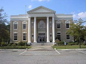 Dodge County Courthouse in Eastman | |
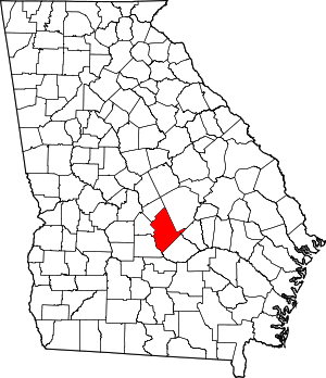 Location within the U.S. state of Georgia | |
 Georgia's location within the U.S. | |
| Coordinates: 32°10′N 83°10′W | |
| Country | |
| State | |
| Founded | 1870 |
| Named for | William E. Dodge |
| Seat | Eastman |
| Largest city | Eastman |
| Area | |
| • Total | 503 sq mi (1,300 km2) |
| • Land | 496 sq mi (1,280 km2) |
| • Water | 7.2 sq mi (19 km2) 1.4%% |
| Population | |
| • Estimate (2019) | 20,605 |
| • Density | 44/sq mi (17/km2) |
| Time zone | UTC−5 (Eastern) |
| • Summer (DST) | UTC−4 (EDT) |
| Congressional district | 8th |
| Website | www |
History
Prior to 1802, this section of Georgia was owned by the Creek Indians. Treaties were made in 1802-1805 by which all lands east of the Ocmulgee River were taken from the Creek Indians. This land was distributed by lottery to the citizens of Georgia. In 1803 Wilkinson County was organized under that treaty. Telfair and Laurens counties were formed from Wilkinson County. In 1808 Pulaski County was formed from Laurens. In 1869, the Macon and Brunswick Railroad was built. Towns began to spring up all up and down the line, and, as this section was so far removed from the county seat, Hawkinsville, it was deemed expedient to create a new county and place the county seat at this point.[3] A large portion of the county was taken from Laurens County, and also smaller portions from Pulaski, Montgomery, and Telfair counties. Dodge County was organized on October 26, 1870, during the Reconstruction era. The county was named by the Republican-dominated legislature for William E. Dodge.[4] The county courthouse was built by Dodge and used until 1908, on the same area the courthouse stands now.
Geography
According to the U.S. Census Bureau, the county has a total area of 503 square miles (1,300 km2), of which 496 square miles (1,280 km2) is land and 7.2 square miles (19 km2) (1.4%) is water.[5]
The western half of Dodge County, roughly west of Eastman, is located in the Lower Ocmulgee River sub-basin of the Altamaha River basin. The eastern half of the county is located in the Little Ocmulgee River sub-basin of the same Altamaha River basin, with a small northern corner of Dodge County, north and west of Chester, located in the Lower Oconee River sub-basin of the larger Alamaha River basin.[6] The rivers were important for trade, carrying cotton and timber downriver to markets.
Adjacent counties
- Laurens County - northeast
- Wheeler County - east
- Telfair County - southeast
- Wilcox County - west
- Pulaski County - west
- Bleckley County - northwest
Demographics
| Historical population | |||
|---|---|---|---|
| Census | Pop. | %± | |
| 1880 | 5,358 | — | |
| 1890 | 11,452 | 113.7% | |
| 1900 | 13,975 | 22.0% | |
| 1910 | 20,127 | 44.0% | |
| 1920 | 22,540 | 12.0% | |
| 1930 | 21,599 | −4.2% | |
| 1940 | 21,022 | −2.7% | |
| 1950 | 17,865 | −15.0% | |
| 1960 | 16,483 | −7.7% | |
| 1970 | 15,658 | −5.0% | |
| 1980 | 16,955 | 8.3% | |
| 1990 | 17,607 | 3.8% | |
| 2000 | 19,171 | 8.9% | |
| 2010 | 21,796 | 13.7% | |
| Est. 2019 | 20,605 | [7] | −5.5% |
| U.S. Decennial Census[8] 1790-1960[9] 1900-1990[10] 1990-2000[11] 2010-2019[1] | |||
2010 census
As of the 2010 United States Census, there were 21,796 people, 8,177 households, and 5,528 families residing in the county.[12] The population density was 44.0 inhabitants per square mile (17.0/km2). There were 9,857 housing units at an average density of 19.9 per square mile (7.7/km2).[13] The racial makeup of the county was 66.8% white, 29.8% black or African American, 0.5% Asian, 0.3% American Indian, 0.1% Pacific islander, 1.6% from other races, and 1.0% from two or more races. Those of Hispanic or Latino origin made up 3.4% of the population.[12] In terms of ancestry, 33.5% were English, and 12.9% were American.[14]
Of the 8,177 households, 33.6% had children under the age of 18 living with them, 45.7% were married couples living together, 16.4% had a female householder with no husband present, 32.4% were non-families, and 28.7% of all households were made up of individuals. The average household size was 2.43 and the average family size was 2.96. The median age was 38.5 years.[12]
The median income for a household in the county was $33,580 and the median income for a family was $46,460. Males had a median income of $38,050 versus $28,418 for females. The per capita income for the county was $16,288. About 17.1% of families and 20.0% of the population were below the poverty line, including 22.7% of those under age 18 and 18.1% of those age 65 or over.[15]
Transportation
Major highways


Airport
The Heart of Georgia Regional Airport[16] is located three miles east of Eastman off of State Route 46. Elevation 304'. Runway 02/20 is 6,506'x100'and has a precision instrument landing system. The airport is owned by the Heart of Georgia Regional Airport Authority and is home to the Middle Georgia State College Georgia Aviation campus. Middle Georgia State College operates the Federal Aviation Administration's #1 ranked student control tower in the United States.[17] Other businesses at the airport include aircraft manufacturing, aircraft metal finishing, and general metal fabrication. The airport's fixed-base operator is located in the terminal building midfield. The terminal building is named after W. S. Stuckey, Sr., founder of Stuckey's Candy Company[18] (now Standard Candy) an aviation pioneer who is from Eastman.
Education
Communities
Unincorporated Communities
Politics
| Year | Republican | Democratic | Third parties |
|---|---|---|---|
| 2016 | 71.6% 5,021 | 26.2% 1,839 | 2.1% 149 |
| 2012 | 67.2% 5,214 | 31.5% 2,442 | 1.3% 98 |
| 2008 | 67.4% 5,543 | 31.6% 2,595 | 1.1% 86 |
| 2004 | 65.5% 4,584 | 34.1% 2,384 | 0.4% 28 |
| 2000 | 59.1% 3,472 | 39.6% 2,326 | 1.3% 79 |
| 1996 | 42.9% 2,478 | 46.6% 2,696 | 10.5% 607 |
| 1992 | 36.4% 2,287 | 47.8% 3,002 | 15.8% 989 |
| 1988 | 55.0% 2,677 | 44.4% 2,164 | 0.6% 31 |
| 1984 | 52.4% 2,765 | 47.6% 2,513 | |
| 1980 | 26.6% 1,719 | 71.8% 4,635 | 1.5% 99 |
| 1976 | 13.9% 848 | 86.1% 5,267 | |
| 1972 | 83.1% 4,346 | 16.9% 884 | |
| 1968 | 18.5% 1,055 | 21.6% 1230 | 59.9% 3,406 |
| 1964 | 58.0% 3,285 | 42.0% 2,376 | |
| 1960 | 23.8% 1,134 | 76.2% 3,630 | |
| 1956 | 17.5% 738 | 82.5% 3,479 | |
| 1952 | 11.6% 454 | 88.4% 3,445 | |
| 1948 | 21.5% 532 | 69.8% 1,725 | 8.7% 216 |
| 1944 | 14.2% 237 | 85.8% 1,437 | |
| 1940 | 11.7% 171 | 87.9% 1,280 | 0.3% 5 |
| 1936 | 5.3% 71 | 94.2% 1,259 | 0.5% 6 |
| 1932 | 1.2% 33 | 98.8% 2,809 | 0.0% 1 |
| 1928 | 28.7% 273 | 71.3% 677 | |
| 1924 | 5.2% 91 | 94.3% 1,654 | 0.5% 9 |
| 1920 | 22.0% 177 | 78.0% 627 | |
| 1916 | 4.0% 35 | 88.8% 788 | 7.2% 64 |
| 1912 | 3.9% 28 | 94.5% 684 | 1.7% 12 |
References
- United States Census Bureau. "State & County QuickFacts". United States Census Bureau. Archived from the original on June 7, 2011. Retrieved June 21, 2014.
- National Association of Counties. "Find a County". National Association of Counties. Archived from the original on May 31, 2011. Retrieved June 7, 2011.
- Cobb, Addie Davis (1979) [1932]. History of Dodge County. Spartanburg, SC: Reprint Co. ISBN 0871522934. OCLC 4774891.
- Gannett, Henry (1905). The Origin of Certain Place Names in the United States. Washington, DC: Government Printing Office. pp. 107.
- United States Census Bureau (February 12, 2011). "US Gazetteer files: 2010, 2000, and 1990". United States Census Bureau. Retrieved April 23, 2011.
- Georgia Soil and Water Conservation Commission. Georgia Soil and Water Conservation Commission Interactive Mapping Experience (Map). Georgia Soil and Water Conservation Commission. Retrieved November 27, 2015.
- "Population and Housing Unit Estimates". Retrieved May 21, 2020.
- United States Census Bureau. "U.S. Decennial Census". United States Census Bureau. Retrieved June 21, 2014.
- University of Virginia Library. "Historical Census Browser". University of Virginia Library. Retrieved June 21, 2014.
- United States Census Bureau. "Population of Counties by Decennial Census: 1900 to 1990". United States Census Bureau. Retrieved June 21, 2014.
- United States Census Bureau. "Census 2000 PHC-T-4. Ranking Tables for Counties: 1990 and 2000" (PDF). United States Census Bureau. Retrieved June 21, 2014.
- United States Census Bureau. "DP-1 Profile of General Population and Housing Characteristics: 2010 Demographic Profile Data". United States Census Bureau. Archived from the original on February 13, 2020. Retrieved December 29, 2015.
- United States Census Bureau. "Population, Housing Units, Area, and Density: 2010 - County". United States Census Bureau. Archived from the original on February 13, 2020. Retrieved December 29, 2015.
- United States Census Bureau. "DP02 Selected Social Characteristics in the United States". 2006–2010 American Community Survey 5-Year Estimates. United States Census Bureau. Archived from the original on February 13, 2020. Retrieved December 29, 2015.
- United States Census Bureau. "DP03 Selected Economic Characteristics". 2006-2010 American Community Survey 5-Year Estimates. United States Census Bureau. Archived from the original on February 13, 2020. Retrieved December 29, 2015.
- Heart of Georgia Regional Airport. "Heart of Georgia Regional Airport". Heart of Georgia Regional Airport. Retrieved March 19, 2011.
- Pace, Ramey. "Air Traffic Management". Middle Georgia College. Archived from the original on March 13, 2011. Retrieved March 19, 2011.
- Stuckey's Candy Company. "Stuckey's Candy Company". Stuckey's Candy Company. Archived from the original on May 19, 2011. Retrieved March 19, 2011.
- Leip, David (2016). "United States Presidential Election Results". David Leip's Atlas of U.S. Presidential Elections. David Leip. Retrieved October 2, 2017.
External links
- Dodge County
- Dodge County historical marker
Places adjacent to Dodge County, Georgia | ||||||||||
|---|---|---|---|---|---|---|---|---|---|---|
| ||||||||||
Municipalities and communities of Dodge County, Georgia, United States | ||
|---|---|---|
| City | Map of Georgia highlighting Dodge County | |
| Towns | ||
| CDPs | ||
| Unincorporated communities | ||
| Footnotes | ‡This populated place also has portions in an adjacent county or counties | |

| Authority control |
|
|---|