Thomas County, Georgia
Thomas County is a county located in the U.S. state of Georgia. As of the 2010 census the population was 44,720.[1] The county seat is Thomasville.[2]
Thomas County | |
|---|---|
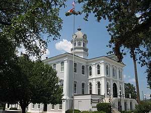 Former Thomas County Courthouse in Thomasville | |
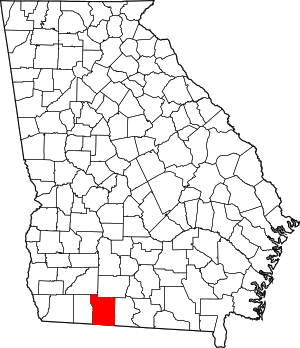 Location within the U.S. state of Georgia | |
 Georgia's location within the U.S. | |
| Coordinates: 30°52′N 83°55′W | |
| Country | |
| State | |
| Founded | December 23, 1825 |
| Named for | Jett Thomas |
| Seat | Thomasville |
| Largest city | Thomasville |
| Area | |
| • Total | 552 sq mi (1,430 km2) |
| • Land | 545 sq mi (1,410 km2) |
| • Water | 7.6 sq mi (20 km2) 1.4%% |
| Population | |
| • Estimate (2018) | 44,448 |
| • Density | 82/sq mi (32/km2) |
| Time zone | UTC−5 (Eastern) |
| • Summer (DST) | UTC−4 (EDT) |
| Congressional district | 8th |
| Website | www |
Thomas County comprises the Thomasville, GA Micropolitan Statistical Area.
History
Thomas County was created by an act of the Georgia General Assembly on December 23, 1825, from portions of Decatur and Irwin counties.[3] Colquitt (1856), Brooks (1858), and Grady (1905) counties all were formed partially from lands within Thomas County's original borders.
The county is named for Jett Thomas, officer in the War of 1812 who is also known for overseeing the construction of the first building at the University of Georgia (originally referred to as Franklin College and known today as Old College) as well as the state capitol at Milledgeville.
Geography
According to the U.S. Census Bureau, the county has a total area of 552 square miles (1,430 km2), of which 545 square miles (1,410 km2) is land and 7.6 square miles (20 km2) (1.4%) is water.[4]
The northwestern half of Thomas County, bordered by U.S. Route 319 southwest of Thomasville, and a line that ends up bisecting the distance between Coolidge and Pavo in the northeast, is located in the Upper Ochlockonee River sub-basin of the larger Ochlockonee River basin. The northeastern edge of the county, from north of Pavo to Boston, is located in the Withlacoochee River sub-basin of the Suwannee River basin. The southeastern portion of Thomas County, running southeast from Thomasville, is located in the Aucilla River sub-basin of the larger Aucilla-Waccasassa basin. Almost all of the southwestern portion of the county is located in the Apalachee Bay-St, Marks sub-basin of the Ochlockonee River basin, with the exception of the tiny southwestern-most corner, which is located in the Lower Ochlockonee River sub-basin of the same Ochlockonee River basin.[5]
The Aucilla River rises in Thomas County. The Red Hills Region is centered on Thomas County.
Major highways


Adjacent counties
- Colquitt County - northeast
- Brooks County - east
- Jefferson County, Florida - south
- Leon County, Florida - southwest
- Grady County - west
- Mitchell County - northwest
Demographics
| Historical population | |||
|---|---|---|---|
| Census | Pop. | %± | |
| 1830 | 3,299 | — | |
| 1840 | 6,766 | 105.1% | |
| 1850 | 10,103 | 49.3% | |
| 1860 | 10,766 | 6.6% | |
| 1870 | 14,523 | 34.9% | |
| 1880 | 20,597 | 41.8% | |
| 1890 | 26,154 | 27.0% | |
| 1900 | 31,076 | 18.8% | |
| 1910 | 29,071 | −6.5% | |
| 1920 | 33,044 | 13.7% | |
| 1930 | 32,612 | −1.3% | |
| 1940 | 31,289 | −4.1% | |
| 1950 | 33,932 | 8.4% | |
| 1960 | 34,319 | 1.1% | |
| 1970 | 34,515 | 0.6% | |
| 1980 | 38,098 | 10.4% | |
| 1990 | 38,986 | 2.3% | |
| 2000 | 42,737 | 9.6% | |
| 2010 | 44,720 | 4.6% | |
| Est. 2018 | 44,448 | [6] | −0.6% |
| U.S. Decennial Census[7] 1790-1960[8] 1900-1990[9] 1990-2000[10] 2010-2013[1] | |||
2000 census
As of the census[11] of 2000, there were 44,737 people, 16,309 households, and 11,465 families living in the county. The population density was 78 people per square mile (30/km²). There were 18,285 housing units at an average density of 33 per square mile (13/km²). The racial makeup of the county was 58.98% White, 38.86% Black or African American, 0.29% Native American, 0.41% Asian, 0.06% Pacific Islander, 0.54% from other races, and 0.85% from two or more races. 1.72% of the population were Hispanic or Latino of any race.
There were 16,309 households out of which 32.70% had children under the age of 18 living with them, 47.90% were married couples living together, 18.40% had a female householder with no husband present, and 29.70% were non-families. 25.80% of all households were made up of individuals and 10.60% had someone living alone who was 65 years of age or older. The average household size was 2.55 and the average family size was 3.06.
In the county, the population was spread out with 27.10% under the age of 18, 8.10% from 18 to 24, 28.20% from 25 to 44, 22.90% from 45 to 64, and 13.70% who were 65 years of age or older. The median age was 36 years. For every 100 females there were 88.90 males. For every 100 females age 18 and over, there were 84.80 males.
As of 2007, the median income for a household in the county was $40,498, and the median income for a family was $52,392.[12] Males had a median income of $28,395 versus $21,344 for females. The per capita income for the county was $21,540. About 13.60% of families and 17.40% of the population were below the poverty line, including 21.90% of those under age 18 and 19.30% of those age 65 or over.
2010 census
As of the 2010 United States Census, there were 44,720 people, 17,573 households, and 11,999 families living in the county.[13] The population density was 82.1 inhabitants per square mile (31.7/km2). There were 20,177 housing units at an average density of 37.0 per square mile (14.3/km2).[14] The racial makeup of the county was 59.6% white, 36.9% black or African American, 0.7% Asian, 0.4% American Indian, 1.2% from other races, and 1.2% from two or more races. Those of Hispanic or Latino origin made up 2.9% of the population.[13] In terms of ancestry, 15.5% were American, 9.0% were English, 8.2% were Irish, and 6.4% were German.[15]
Of the 17,573 households, 33.8% had children under the age of 18 living with them, 45.2% were married couples living together, 18.3% had a female householder with no husband present, 31.7% were non-families, and 27.2% of all households were made up of individuals. The average household size was 2.50 and the average family size was 3.03. The median age was 39.6 years.[13]
The median income for a household in the county was $35,797 and the median income for a family was $46,333. Males had a median income of $38,520 versus $27,085 for females. The per capita income for the county was $21,261. About 17.1% of families and 22.8% of the population were below the poverty line, including 31.2% of those under age 18 and 12.9% of those age 65 or over.[16]
Education
Communities
Cities
- Barwick (partly in Brooks County)
- Boston
- Coolidge
- Meigs (partly in Mitchell County)
- Pavo (partly in Brooks County)
- Thomasville
Town
Unincorporated community
- Metcalf
Politics
| Year | Republican | Democratic | Third parties |
|---|---|---|---|
| 2016 | 59.7% 11,228 | 38.0% 7,142 | 2.3% 432 |
| 2012 | 58.7% 11,156 | 40.3% 7,653 | 1.0% 183 |
| 2008 | 57.5% 10,642 | 41.7% 7,720 | 0.7% 132 |
| 2004 | 61.4% 9,659 | 38.1% 5,997 | 0.5% 77 |
| 2000 | 58.8% 7,093 | 40.3% 4,862 | 0.9% 103 |
| 1996 | 49.0% 5,649 | 45.0% 5,183 | 6.0% 686 |
| 1992 | 46.0% 5,500 | 40.5% 4,841 | 13.5% 1607 |
| 1988 | 64.8% 6,572 | 34.8% 3,530 | 0.4% 43 |
| 1984 | 61.4% 6,427 | 38.6% 4,039 | |
| 1980 | 42.3% 4,294 | 56.1% 5,695 | 1.7% 172 |
| 1976 | 34.7% 3,263 | 65.3% 6,147 | |
| 1972 | 75.4% 6,668 | 24.6% 2,171 | |
| 1968 | 22.9% 2,261 | 26.2% 2585 | 51.0% 5,039 |
| 1964 | 65.9% 6,306 | 34.1% 3,257 | |
| 1960 | 41.5% 2,285 | 58.5% 3,226 | |
| 1956 | 38.9% 2,240 | 61.1% 3,522 | |
| 1952 | 36.4% 2,273 | 63.6% 3,971 | |
| 1948 | 35.3% 1,295 | 39.0% 1,429 | 25.7% 943 |
| 1944 | 24.2% 557 | 75.8% 1,747 | 0.0% 1 |
| 1940 | 15.2% 371 | 84.6% 2,072 | 0.2% 5 |
| 1936 | 8.4% 222 | 91.1% 2,409 | 0.5% 14 |
| 1932 | 3.3% 90 | 96.2% 2,607 | 0.5% 13 |
| 1928 | 39.6% 814 | 60.4% 1,240 | |
| 1924 | 7.9% 115 | 87.5% 1,280 | 4.7% 68 |
| 1920 | 12.9% 168 | 87.1% 1,130 | |
| 1916 | 11.4% 173 | 85.8% 1,298 | 2.8% 42 |
| 1912 | 12.4% 150 | 83.5% 1,012 | 4.1% 50 |
References
- "State & County QuickFacts". United States Census Bureau. Retrieved June 26, 2014.
- "Find a County". National Association of Counties. Retrieved June 7, 2011.
- Krakow, Kenneth K. (1975). Georgia Place-Names: Their History and Origins (PDF). Macon, GA: Winship Press. p. 225. ISBN 0-915430-00-2.
- "US Gazetteer files: 2010, 2000, and 1990". United States Census Bureau. February 12, 2011. Retrieved April 23, 2011.
- "Georgia Soil and Water Conservation Commission Interactive Mapping Experience". Georgia Soil and Water Conservation Commission. Retrieved November 25, 2015.
- "Population and Housing Unit Estimates". Retrieved July 31, 2019.
- "U.S. Decennial Census". United States Census Bureau. Retrieved June 26, 2014.
- "Historical Census Browser". University of Virginia Library. Retrieved June 26, 2014.
- "Population of Counties by Decennial Census: 1900 to 1990". United States Census Bureau. Retrieved June 26, 2014.
- "Census 2000 PHC-T-4. Ranking Tables for Counties: 1990 and 2000" (PDF). United States Census Bureau. Retrieved June 26, 2014.
- "U.S. Census website". United States Census Bureau. Retrieved May 14, 2011.
- "American FactFinder". Factfinder.census.gov. Archived from the original on February 10, 2020. Retrieved December 22, 2012.
- "DP-1 Profile of General Population and Housing Characteristics: 2010 Demographic Profile Data". United States Census Bureau. Archived from the original on February 13, 2020. Retrieved December 30, 2015.
- "Population, Housing Units, Area, and Density: 2010 - County". United States Census Bureau. Archived from the original on February 13, 2020. Retrieved December 30, 2015.
- "DP02 SELECTED SOCIAL CHARACTERISTICS IN THE UNITED STATES – 2006-2010 American Community Survey 5-Year Estimates". United States Census Bureau. Archived from the original on February 13, 2020. Retrieved December 30, 2015.
- "DP03 SELECTED ECONOMIC CHARACTERISTICS – 2006-2010 American Community Survey 5-Year Estimates". United States Census Bureau. Archived from the original on February 13, 2020. Retrieved December 30, 2015.
- Leip, David. "Dave Leip's Atlas of U.S. Presidential Elections". uselectionatlas.org. Retrieved March 22, 2018.
External links
- Thomas County
- University of Georgia Thomas County Cooperative Extension Website
- Thomasville Landmarks - Historic preservation organization
- Thomas County Historical Society & Museum of History
Places adjacent to Thomas County, Georgia | ||||||||||
|---|---|---|---|---|---|---|---|---|---|---|
| ||||||||||
Municipalities and communities of Thomas County, Georgia, United States | ||
|---|---|---|
| Cities | Map of Georgia highlighting Thomas County | |
| Town | ||
| Unincorporated communities | ||
| Footnotes | ‡This populated place also has portions in an adjacent county or counties | |
