Wheeler County, Georgia
Wheeler County is a county located in the central portion of the U.S. state of Georgia. As of the 2010 census, the population was 7,421.[1] The county is one of the most impoverished counties in the nation. The county seat is Alamo.[2] The American Community Survey's 2009–2013 average reports that the county's per-capita income of $8,948 makes it the second-poorest county in the United States by this metric.[3]
Wheeler County | |
|---|---|
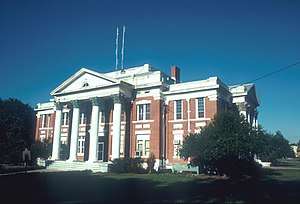 Wheeler County Courthouse (built 1917), Alamo | |
 Location within the U.S. state of Georgia | |
 Georgia's location within the U.S. | |
| Coordinates: 32°07′N 82°43′W | |
| Country | |
| State | |
| Founded | November 5, 1912 |
| Named for | Joseph Wheeler |
| Seat | Alamo |
| Largest city | Alamo |
| Area | |
| • Total | 300 sq mi (800 km2) |
| • Land | 295 sq mi (760 km2) |
| • Water | 4.8 sq mi (12 km2) 1.6%% |
| Population | |
| • Estimate (2018) | 7,879 |
| • Density | 25/sq mi (10/km2) |
| Time zone | UTC−5 (Eastern) |
| • Summer (DST) | UTC−4 (EDT) |
| Congressional district | 12th |
| Website | wheelercounty |
History
Wheeler County is named after Confederate General Joseph Wheeler.[4] The constitutional amendment to create the county was proposed August 14, 1912, and ratified November 5, 1912.
Geography
According to the U.S. Census Bureau, the county has a total area of 300 square miles (780 km2), of which 295 square miles (760 km2) is land and 4.8 square miles (12 km2) (1.6%) is water.[5]
The eastern portion of Wheeler County, defined by a line running from north of Alamo to the southern border of the county, due south of Mount Vernon, is located in the Lower Oconee River sub-basin of the Altamaha River basin. The bulk of the rest of the county is located in the Little Ocmulgee River sub-basin of the same Altamaha River basin, except for a small southern portion of Wheeler County, east of Lumber City, which is located in the Lower Ocmulgee River sub-basin of the larger Altamaha River basin.[6]
Major highways


Adjacent counties
- Treutlen County (north)
- Montgomery County (east)
- Jeff Davis County (southeast)
- Telfair County (southwest)
- Dodge County (west)
- Laurens County (northwest)
Demographics
| Historical population | |||
|---|---|---|---|
| Census | Pop. | %± | |
| 1920 | 9,817 | — | |
| 1930 | 9,149 | −6.8% | |
| 1940 | 8,535 | −6.7% | |
| 1950 | 6,712 | −21.4% | |
| 1960 | 5,342 | −20.4% | |
| 1970 | 4,596 | −14.0% | |
| 1980 | 5,155 | 12.2% | |
| 1990 | 4,903 | −4.9% | |
| 2000 | 6,179 | 26.0% | |
| 2010 | 7,421 | 20.1% | |
| Est. 2018 | 7,879 | [7] | 6.2% |
| U.S. Decennial Census[8] 1790-1960[9] 1900-1990[10] 1990-2000[11] 2010-2013[1] | |||
2000 census
At the 2000 census there were 6,179 people, 2,011 households, and 1,395 families living in the county. The population density was 21 people per square mile (8/km²). There were 2,447 housing units at an average density of 8 per square mile (3/km²). The racial makeup of the county was 64.56% White, 33.18% Black or African American, 0.13% Native American, 0.10% Asian, 1.25% from other races, and 0.79% from two or more races. 3.54% of the population were Hispanic or Latino of any race.[12] Of the 2,011 households 32.60% had children under the age of 18 living with them, 52.10% were married couples living together, 13.00% had a female householder with no husband present, and 30.60% were non-families. 27.80% of households were one person and 14.80% were one person aged 65 or older. The average household size was 2.54 and the average family size was 3.08.
The age distribution was 22.40% under the age of 18, 10.20% from 18 to 24, 31.60% from 25 to 44, 23.10% from 45 to 64, and 12.70% 65 or older. The median age was 36 years. For every 100 females there were 128.10 males. For every 100 females age 18 and over, there were 139.80 males.
The median household income was $24,053 and the median family income was $29,696. Males had a median income of $27,203 versus $22,679 for females. The per capita income for the county was $13,005. About 21.60% of families and 25.30% of the population were below the poverty line, including 30.20% of those under age 18 and 26.70% of those age 65 or over.
2010 census
At the 2010 census, there were 7,421 people, 2,152 households, and 1,519 families living in the county.[13] The population density was 25.1 inhabitants per square mile (9.7/km2). There were 2,625 housing units at an average density of 8.9 per square mile (3.4/km2).[14] The racial makeup of the county was 61.3% white, 35.2% black or African American, 0.2% Asian, 0.1% American Indian, 2.3% from other races, and 0.8% from two or more races. Those of Hispanic or Latino origin made up 4.8% of the population.[13] In terms of ancestry, 32.4% were English, and 8.1% were American.[15]
Of the 2,152 households, 34.2% had children under the age of 18 living with them, 49.6% were married couples living together, 15.5% had a female householder with no husband present, 29.4% were non-families, and 26.0% of households were made up of individuals. The average household size was 2.54 and the average family size was 3.05. The median age was 37.9 years.[13]
The median household income was $35,422 and the median family income was $45,042. Males had a median income of $35,114 versus $25,329 for females. The per capita income for the county was $10,043. About 14.3% of families and 24.3% of the population were below the poverty line, including 31.6% of those under age 18 and 36.4% of those age 65 or over.[16]
Politics
| Year | Republican | Democratic | Third parties |
|---|---|---|---|
| 2016 | 67.6% 1,421 | 30.7% 646 | 1.7% 35 |
| 2012 | 63.1% 1,366 | 35.7% 772 | 1.3% 27 |
| 2008 | 63.6% 1,408 | 35.9% 794 | 0.5% 12 |
| 2004 | 58.0% 1,192 | 41.2% 847 | 0.7% 15 |
| 2000 | 51.6% 813 | 47.8% 752 | 0.6% 10 |
| 1996 | 33.9% 460 | 55.3% 751 | 10.8% 146 |
| 1992 | 35.4% 601 | 51.8% 880 | 12.8% 218 |
| 1988 | 51.6% 709 | 47.9% 658 | 0.4% 6 |
| 1984 | 51.8% 833 | 48.2% 774 | |
| 1980 | 25.2% 550 | 73.2% 1,599 | 1.7% 37 |
| 1976 | 20.0% 344 | 80.0% 1,378 | |
| 1972 | 78.8% 1,093 | 21.2% 294 | |
| 1968 | 15.0% 251 | 29.2% 488 | 55.8% 934 |
| 1964 | 46.4% 849 | 53.6% 980 | |
| 1960 | 18.9% 226 | 81.1% 970 | |
| 1956 | 13.1% 149 | 86.9% 992 | |
| 1952 | 16.9% 261 | 83.1% 1,280 | |
| 1948 | 32.3% 286 | 63.3% 560 | 4.4% 39 |
| 1944 | 22.6% 151 | 77.4% 517 | |
| 1940 | 19.0% 117 | 80.5% 495 | 0.5% 3 |
| 1936 | 13.6% 94 | 86.2% 594 | 0.2% 1 |
| 1932 | 2.5% 29 | 97.4% 1,127 | 0.1% 1 |
| 1928 | 24.5% 101 | 75.5% 312 | |
| 1924 | 0.0% 0 | 88.8% 772 | 11.2% 97 |
| 1920 | 22.4% 101 | 77.6% 350 | |
| 1916 | 9.0% 40 | 84.0% 372 | 7.0% 31 |
References
- "State & County QuickFacts". United States Census Bureau. Retrieved June 27, 2014.
- "Find a County". National Association of Counties. Retrieved June 7, 2011.
- United States counties by per capita income
- Krakow, Kenneth K. (1975). Georgia Place-Names: Their History and Origins (PDF). Macon, GA: Winship Press. p. 251. ISBN 0-915430-00-2.
- "US Gazetteer files: 2010, 2000, and 1990". United States Census Bureau. February 12, 2011. Retrieved April 23, 2011.
- "Georgia Soil and Water Conservation Commission Interactive Mapping Experience". Georgia Soil and Water Conservation Commission. Retrieved November 24, 2015.
- "Population and Housing Unit Estimates". Retrieved July 31, 2019.
- "U.S. Decennial Census". United States Census Bureau. Retrieved June 27, 2014.
- "Historical Census Browser". University of Virginia Library. Retrieved June 27, 2014.
- "Population of Counties by Decennial Census: 1900 to 1990". United States Census Bureau. Retrieved June 27, 2014.
- "Census 2000 PHC-T-4. Ranking Tables for Counties: 1990 and 2000" (PDF). United States Census Bureau. Retrieved June 27, 2014.
- "U.S. Census website". United States Census Bureau. Retrieved January 31, 2008.
- "DP-1 Profile of General Population and Housing Characteristics: 2010 Demographic Profile Data". United States Census Bureau. Archived from the original on February 13, 2020. Retrieved December 30, 2015.
- "Population, Housing Units, Area, and Density: 2010 - County". United States Census Bureau. Archived from the original on February 13, 2020. Retrieved December 30, 2015.
- "DP02 SELECTED SOCIAL CHARACTERISTICS IN THE UNITED STATES – 2006-2010 American Community Survey 5-Year Estimates". United States Census Bureau. Archived from the original on February 13, 2020. Retrieved December 30, 2015.
- "DP03 SELECTED ECONOMIC CHARACTERISTICS – 2006-2010 American Community Survey 5-Year Estimates". United States Census Bureau. Archived from the original on February 13, 2020. Retrieved December 30, 2015.
- Leip, David. "Dave Leip's Atlas of U.S. Presidential Elections". uselectionatlas.org. Retrieved March 24, 2018.
Places adjacent to Wheeler County, Georgia | ||||||||||
|---|---|---|---|---|---|---|---|---|---|---|
| ||||||||||
Municipalities and communities of Wheeler County, Georgia, United States | ||
|---|---|---|
| Cities | Map of Georgia highlighting Wheeler County | |
| Unincorporated community | ||
| Footnotes | ‡This populated place also has portions in an adjacent county or counties | |

| Authority control |
|
|---|