Bryan County, Georgia
Bryan County is a county located in the U.S. state of Georgia. As of the 2010 census, the population was 30,233.[1] The county seat is Pembroke.[2]
Bryan County | |
|---|---|
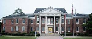 Bryan County Courthouse in Pembroke | |
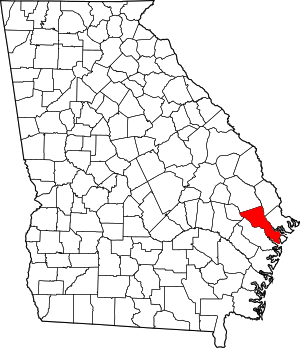 Location within the U.S. state of Georgia | |
 Georgia's location within the U.S. | |
| Coordinates: 32°01′N 81°26′W | |
| Country | |
| State | |
| Founded | 1793 |
| Named for | Jonathan Bryan |
| Seat | Pembroke |
| Largest city | Richmond Hill |
| Area | |
| • Total | 454 sq mi (1,180 km2) |
| • Land | 436 sq mi (1,130 km2) |
| • Water | 18 sq mi (50 km2) 4.1%% |
| Population | |
| • Estimate (2019) | 39,627 |
| • Density | 69/sq mi (27/km2) |
| Time zone | UTC−5 (Eastern) |
| • Summer (DST) | UTC−4 (EDT) |
| Congressional district | 1st |
| Website | www |
Bryan County is part of the Savannah, GA Metropolitan Statistical Area.
Bryan County is separated into two parts (North Bryan and South Bryan) due to the location of Fort Stewart in the middle of the county. The Bryan County Courthouse is listed on the National Register of Historic Places.
History
Bryan County was created on December 19, 1793, named after Jonathan Bryan (1708–1788), an American Revolutionary War partisan.[3]
South Bryan County is home to the earthen Civil War installation Fort McAllister (now Fort McAllister Historic Park) which Gen. William Sherman captured on his March to the Sea.
The colonial town of Hardwick, laid out in 1755, served as the initial county seat. In 1797, the Georgia General Assembly moved the county seat to Cross Roads near modern Richmond Hil. On November 18, 1814, the county seat was moved to Mansford on the Canoochee River.[4] In 1860, the seat was known as Eden. By the 1880s the county seat was known as Bryan. By 1895 it was in Clyde, which may have been the same location formerly known as Eden and Mansford. Clyde served as the seat to 1935; in 1937 Pembroke took on that role. The only remaining sign of Clyde is a cemetery on the Fort Stewart military reservation.
Geography
According to the U.S. Census Bureau, the county has a total area of 454 square miles (1,180 km2), of which 436 square miles (1,130 km2) is land and 18 square miles (47 km2) (4.1%) is water.[5]
A triangular area in the northeast of Bryan County, from northwest of Pembroke to north of Richmond Hill, is located in the Lower Ogeechee River sub-basin of the Ogeechee River basin, as is the northern half of the remaining area in the county south of Richmond Hill. The northwestern portion of the county, from east of Daisy to Richmond Hill, is located in the Canoochee River sub-basin of the Ogeechee River basin. The rest of Bryan County is located in the Ogeechee Coastal sub-basin of the same Ogeechee River basin.[6]
Bryan County is unique in that it is totally divided by the military installation at Ft. Stewart. Pembroke is in more rural north Bryan, while Richmond Hill in south Bryan county is a suburb of Savannah. To travel between the two on public roads, it is necessary to leave the county.
Major highways


Adjacent counties
- Effingham County, Georgia - north
- Chatham County, Georgia - northeast
- Liberty County, Georgia - south/southwest
- Evans County, Georgia - west
- Bulloch County, Georgia - northwest
Demographics
| Historical population | |||
|---|---|---|---|
| Census | Pop. | %± | |
| 1800 | 2,836 | — | |
| 1810 | 2,827 | −0.3% | |
| 1820 | 3,021 | 6.9% | |
| 1830 | 3,139 | 3.9% | |
| 1840 | 3,182 | 1.4% | |
| 1850 | 3,424 | 7.6% | |
| 1860 | 4,015 | 17.3% | |
| 1870 | 5,252 | 30.8% | |
| 1880 | 4,929 | −6.2% | |
| 1890 | 5,520 | 12.0% | |
| 1900 | 6,122 | 10.9% | |
| 1910 | 6,702 | 9.5% | |
| 1920 | 6,343 | −5.4% | |
| 1930 | 5,952 | −6.2% | |
| 1940 | 6,288 | 5.6% | |
| 1950 | 5,965 | −5.1% | |
| 1960 | 6,226 | 4.4% | |
| 1970 | 6,539 | 5.0% | |
| 1980 | 10,175 | 55.6% | |
| 1990 | 15,438 | 51.7% | |
| 2000 | 23,417 | 51.7% | |
| 2010 | 30,233 | 29.1% | |
| Est. 2019 | 39,627 | [7] | 31.1% |
| U.S. Decennial Census[8] 1790-1960[9] 1900-1990[10] 1990-2000[11] 2010-2019[1] | |||
2000 census
As of the census[12] of 2000, there were 23,417 people, 8,089 households, and 6,511 families living in the county. The population density was 53 people per square mile (20/km²). There were 8,675 housing units at an average density of 20 per square mile (8/km²). The racial makeup of the county was 82.79% White, 14.14% Black or African American, 0.32% Native American, 0.77% Asian, 0.07% Pacific Islander, 0.58% from other races, and 1.34% from two or more races. 1.99% of the population were Hispanic or Latino of any race.
There were 8,089 households out of which 45.00% had children under the age of 18 living with them, 64.40% were married couples living together, 11.90% had a female householder with no husband present, and 19.50% were non-families. 16.40% of all households were made up of individuals and 5.80% had someone living alone who was 65 years of age or older. The average household size was 2.88 and the average family size was 3.22.
In the county, the population was spread out with 31.10% under the age of 18, 8.00% from 18 to 24, 31.90% from 25 to 44, 21.60% from 45 to 64, and 7.30% who were 65 years of age or older. The median age was 33 years. For every 100 females, there were 98.20 males. For every 100 females age 18 and over, there were 94.10 males.
The median income for a household in the county was $48,345, and the median income for a family was $53,680. Males had a median income of $39,606 versus $25,830 for females. The per capita income for the county was $19,794. About 10.70% of families and 11.70% of the population were below the poverty line, including 14.70% of those under age 18 and 12.60% of those age 65 or over.
2010 census
As of the 2010 United States Census, there were 30,233 people, 10,738 households, and 8,462 families living in the county.[13] The population density was 69.3 inhabitants per square mile (26.8/km2). There were 11,842 housing units at an average density of 27.2 per square mile (10.5/km2).[14] The racial makeup of the county was 80.2% white, 14.2% black or African American, 1.6% Asian, 0.3% American Indian, 0.1% Pacific islander, 1.1% from other races, and 2.5% from two or more races. Those of Hispanic or Latino origin made up 4.4% of the population.[13] In terms of ancestry, 17.1% were German, 13.9% were Irish, 10.6% were English, and 7.9% were American.[15]
Of the 10,738 households, 44.6% had children under the age of 18 living with them, 60.3% were married couples living together, 13.9% had a female householder with no husband present, 21.2% were non-families, and 17.7% of all households were made up of individuals. The average household size was 2.81 and the average family size was 3.17. The median age was 35.7 years.[13]
The median income for a household in the county was $63,244 and the median income for a family was $72,118. Males had a median income of $54,707 versus $32,245 for females. The per capita income for the county was $28,365. About 8.8% of families and 11.0% of the population were below the poverty line, including 16.0% of those under age 18 and 12.8% of those age 65 or over.[16]
Education
Communities
Politics
| Year | Republican | Democratic | Third parties |
|---|---|---|---|
| 2016 | 69.4% 10,529 | 26.5% 4,014 | 4.2% 630 |
| 2012 | 70.9% 9,560 | 27.5% 3,707 | 1.6% 209 |
| 2008 | 70.8% 9,112 | 28.3% 3,636 | 0.9% 119 |
| 2004 | 73.7% 7,363 | 25.9% 2,590 | 0.4% 41 |
| 2000 | 68.5% 4,835 | 30.8% 2,172 | 0.7% 52 |
| 1996 | 57.1% 3,577 | 34.3% 2,152 | 8.6% 540 |
| 1992 | 47.1% 2,789 | 34.3% 2,031 | 18.7% 1108 |
| 1988 | 66.2% 2,802 | 33.6% 1,423 | 0.2% 10 |
| 1984 | 61.8% 2,265 | 38.2% 1,398 | |
| 1980 | 37.5% 1,212 | 60.8% 1,966 | 1.8% 57 |
| 1976 | 27.1% 761 | 72.9% 2,045 | |
| 1972 | 84.3% 1,409 | 15.7% 263 | |
| 1968 | 16.1% 381 | 23.6% 560 | 60.3% 1,428 |
| 1964 | 62.6% 1,433 | 37.4% 857 | |
| 1960 | 24.4% 428 | 75.6% 1,323 | |
| 1956 | 21.0% 331 | 79.0% 1,242 | |
| 1952 | 25.4% 331 | 74.6% 971 | |
| 1948 | 26.8% 472 | 65.2% 1,147 | 8.0% 140 |
| 1944 | 11.6% 90 | 88.4% 688 | |
| 1940 | 5.3% 49 | 94.5% 874 | 0.2% 2 |
| 1936 | 9.0% 63 | 90.4% 632 | 0.6% 4 |
| 1932 | 4.6% 17 | 94.6% 353 | 0.8% 3 |
| 1928 | 40.8% 151 | 59.2% 219 | |
| 1924 | 4.3% 9 | 94.2% 196 | 1.4% 3 |
| 1920 | 10.7% 21 | 89.3% 175 | |
| 1916 | 2.8% 9 | 91.9% 295 | 5.3% 17 |
| 1912 | 18.9% 120 | 63.1% 400 | 18.0% 114 |
Notable people
- Gregg Allman - musician, Allman Brothers Band
- Mattie Belle Davis - first woman judge of Metropolitan Court of Dade County, Florida
- Justin Smiley - pro football player, All-American at University of Alabama
- John Smoltz - MLB pitcher, owned a summer home here while playing for the Atlanta Braves
References
- "State & County QuickFacts". United States Census Bureau. Retrieved June 18, 2014.
- "Find a County". National Association of Counties. Archived from the original on May 31, 2011. Retrieved June 7, 2011.
- Krakow, Kenneth K. (1975). Georgia Place-Names: Their History and Origins (PDF). Macon, GA: Winship Press. p. 27. ISBN 0-915430-00-2.
- Acts of the General Assembly of the State of Georgia; Passed in October and November, 1814. 1. pp. 46–47.
- "US Gazetteer files: 2010, 2000, and 1990". United States Census Bureau. February 12, 2011. Retrieved April 23, 2011.
- "Georgia Soil and Water Conservation Commission Interactive Mapping Experience". Georgia Soil and Water Conservation Commission. Retrieved November 22, 2015.
- "Population and Housing Unit Estimates". Retrieved May 21, 2020.
- "U.S. Decennial Census". United States Census Bureau. Retrieved June 18, 2014.
- "Historical Census Browser". University of Virginia Library. Retrieved June 18, 2014.
- "Population of Counties by Decennial Census: 1900 to 1990". United States Census Bureau. Retrieved June 18, 2014.
- "Census 2000 PHC-T-4. Ranking Tables for Counties: 1990 and 2000" (PDF). United States Census Bureau. Retrieved June 18, 2014.
- "U.S. Census website". United States Census Bureau. Retrieved May 14, 2011.
- "DP-1 Profile of General Population and Housing Characteristics: 2010 Demographic Profile Data". United States Census Bureau. Archived from the original on February 13, 2020. Retrieved December 27, 2015.
- "Population, Housing Units, Area, and Density: 2010 - County". United States Census Bureau. Archived from the original on February 13, 2020. Retrieved December 27, 2015.
- "DP02 SELECTED SOCIAL CHARACTERISTICS IN THE UNITED STATES – 2006-2010 American Community Survey 5-Year Estimates". United States Census Bureau. Archived from the original on February 13, 2020. Retrieved December 27, 2015.
- "DP03 SELECTED ECONOMIC CHARACTERISTICS – 2006-2010 American Community Survey 5-Year Estimates". United States Census Bureau. Archived from the original on February 13, 2020. Retrieved December 27, 2015.
- Leip, David. "Dave Leip's Atlas of U.S. Presidential Elections". uselectionatlas.org. Retrieved March 18, 2018.
External links
- Coastal Georgia as seen from the water
- Early Bryan County History
- Official Bryan County Website
- Bryan County Board of Education
- Ft. McAllister State Park
- Bryan County historical marker
Places adjacent to Bryan County, Georgia | ||||||||||
|---|---|---|---|---|---|---|---|---|---|---|
| ||||||||||
Municipalities and communities of Bryan County, Georgia, United States | ||
|---|---|---|
| Cities | Map of Georgia highlighting Bryan County | |
| Unincorporated communities | ||
| Ghost town | ||

| Authority control |
|
|---|