Talbot County, Georgia
Talbot County is a county located in the west central portion of the U.S. state of Georgia. The 2010 census showed a population of 6,865.[1] The county seat and largest city is Talbotton.[2]
Talbot County | |
|---|---|
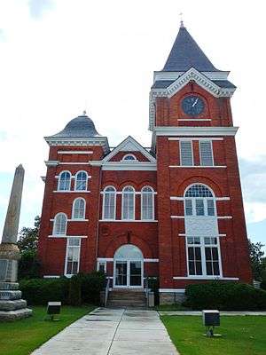 Talbot County Courthouse in Talbotton | |
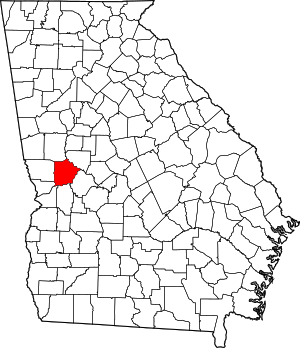 Location within the U.S. state of Georgia | |
 Georgia's location within the U.S. | |
| Coordinates: 32°43′N 84°32′W | |
| Country | |
| State | |
| Founded | December 14, 1827 |
| Named for | Matthew Talbot |
| Seat | Talbotton |
| Largest city | Talbotton |
| Area | |
| • Total | 395 sq mi (1,020 km2) |
| • Land | 391 sq mi (1,010 km2) |
| • Water | 3.4 sq mi (9 km2) 0.9%% |
| Population | |
| • Estimate (2018) | 6,272 |
| • Density | 18/sq mi (7/km2) |
| Time zone | UTC−5 (Eastern) |
| • Summer (DST) | UTC−4 (EDT) |
| Congressional district | 2nd |
| Website | talbotcountyga |
History
Talbot County was created from a portion of Muscogee County by a December 14, 1827 act of the Georgia General Assembly. It was named after the late Georgia governor Matthew Talbot.[3] Taylor County was created from a portion of Talbot County in 1852.
Geography
According to the U.S. Census Bureau, the county has a total area of 395 square miles (1,020 km2), of which 391 square miles (1,010 km2) is land and 3.4 square miles (8.8 km2) (0.9%) is water.[4]
The county straddles the fall line of the Eastern U.S., and thus northern areas of the county are hillier compared to southern areas of the county. The Fall Line Freeway runs across the southern portion of the county, following Georgia State Route 96 from Geneva to Junction City. The far northern portion of the county is part of the Pine Mountain Range, with elevations in this areas exceeding 1,000 ft on the highest peaks of the mountains.
The northeastern three-quarters of Talbot County is located in the Upper Flint River sub-basin of the Apalachicola-Chattahoochee-Flint River Basin. The southwestern quarter, west of Junction City, is located in the Middle Chattahoochee River-Walter F. George Lake sub-basin, while a narrow sliver of the western border, east of Waverly Hall, is located in the Middle Chattahoochee River-Lake Harding sub-basin.[5]
Major highways
Adjacent counties
- Upson County - northeast
- Taylor County - southeast
- Marion County - south
- Chattahoochee County - southwest
- Muscogee County - west-southwest
- Harris County - west
- Meriwether County - north
Railroads
- CSX Fitzgerald Subdivision
- Norfolk Southern Columbus District
Demographics
| Historical population | |||
|---|---|---|---|
| Census | Pop. | %± | |
| 1830 | 5,940 | — | |
| 1840 | 15,627 | 163.1% | |
| 1850 | 16,534 | 5.8% | |
| 1860 | 13,616 | −17.6% | |
| 1870 | 11,913 | −12.5% | |
| 1880 | 14,115 | 18.5% | |
| 1890 | 13,258 | −6.1% | |
| 1900 | 12,197 | −8.0% | |
| 1910 | 11,696 | −4.1% | |
| 1920 | 11,158 | −4.6% | |
| 1930 | 8,458 | −24.2% | |
| 1940 | 8,141 | −3.7% | |
| 1950 | 7,687 | −5.6% | |
| 1960 | 7,127 | −7.3% | |
| 1970 | 6,625 | −7.0% | |
| 1980 | 6,536 | −1.3% | |
| 1990 | 6,524 | −0.2% | |
| 2000 | 6,498 | −0.4% | |
| 2010 | 6,865 | 5.6% | |
| Est. 2018 | 6,272 | [6] | −8.6% |
| U.S. Decennial Census[7] 1790-1960[8] 1900-1990[9] 1990-2000[10] 2010-2013[1] | |||
As of the 2010 United States Census, there were 6,865 people, 2,832 households, and 1,904 families residing in the county.[11] The population density was 17.5 inhabitants per square mile (6.8/km2). There were 3,399 housing units at an average density of 8.7 per square mile (3.4/km2).[12] The racial makeup of the county was 59.2% black or African American, 39.0% white, 0.3% American Indian, 0.1% Asian, 0.4% from other races, and 1.0% from two or more races. Those of Hispanic or Latino origin made up 1.3% of the population.[11] In terms of ancestry, 10.4% were Irish, 7.6% were English, 5.8% were Subsaharan African, and 2.7% were American.[13]
Of the 2,832 households, 28.4% had children under the age of 18 living with them, 42.6% were married couples living together, 19.2% had a female householder with no husband present, 32.8% were non-families, and 28.9% of all households were made up of individuals. The average household size was 2.42 and the average family size was 2.98. The median age was 45.6 years.[11]
The median income for a household in the county was $33,873 and the median income for a family was $43,694. Males had a median income of $41,651 versus $24,750 for females. The per capita income for the county was $18,007. About 18.2% of families and 23.5% of the population were below the poverty line, including 31.7% of those under age 18 and 20.8% of those age 65 or over.[14]
Education
The Talbot County School District holds pre-school to grade twelve, and consists of one building with 48 full-time teachers and 792 students.[15] The district headquarters is in Talbotton.[16]
Communities
Cities
Unincorporated communities
- Box Springs
- Centerville, Talbot County, Georgia
- O'Neals
- Tax
- Roughedge
Politics
| Year | Republican | Democratic | Third parties |
|---|---|---|---|
| 2016 | 36.9% 1,196 | 61.7% 2,002 | 1.5% 48 |
| 2012 | 34.4% 1,202 | 64.8% 2,265 | 0.7% 26 |
| 2008 | 35.2% 1,301 | 64.0% 2,369 | 0.8% 31 |
| 2004 | 37.4% 1,103 | 62.1% 1,830 | 0.5% 14 |
| 2000 | 33.4% 844 | 65.7% 1,662 | 1.0% 25 |
| 1996 | 27.8% 652 | 67.3% 1,579 | 4.9% 115 |
| 1992 | 25.0% 671 | 65.9% 1,768 | 9.1% 243 |
| 1988 | 38.9% 802 | 60.6% 1,248 | 0.5% 10 |
| 1984 | 34.2% 778 | 65.8% 1,494 | |
| 1980 | 25.5% 572 | 72.9% 1,635 | 1.6% 36 |
| 1976 | 21.9% 459 | 78.1% 1,634 | |
| 1972 | 66.1% 990 | 33.9% 508 | |
| 1968 | 20.9% 317 | 33.7% 510 | 45.4% 688 |
| 1964 | 52.0% 679 | 48.0% 627 | |
| 1960 | 21.2% 207 | 78.8% 771 | |
| 1956 | 16.1% 136 | 83.9% 710 | |
| 1952 | 20.5% 175 | 79.5% 678 | |
| 1948 | 16.6% 135 | 71.7% 582 | 11.7% 95 |
| 1944 | 5.1% 45 | 94.9% 832 | |
| 1940 | 6.9% 49 | 92.9% 656 | 0.1% 1 |
| 1936 | 4.9% 41 | 94.4% 796 | 0.7% 6 |
| 1932 | 4.7% 45 | 95.0% 912 | 0.3% 3 |
| 1928 | 12.1% 74 | 87.9% 536 | |
| 1924 | 6.3% 33 | 93.4% 491 | 0.4% 2 |
| 1920 | 10.2% 43 | 89.8% 379 | |
| 1916 | 2.6% 14 | 94.3% 511 | 3.1% 17 |
| 1912 | 16.1% 87 | 82.4% 446 | 1.5% 8 |
References
- "State & County QuickFacts". United States Census Bureau. Retrieved June 26, 2014.
- "Find a County". National Association of Counties. Retrieved June 7, 2011.
- Krakow, Kenneth K. (1975). Georgia Place-Names: Their History and Origins (PDF). Macon, GA: Winship Press. p. 219. ISBN 0-915430-00-2.
- "US Gazetteer files: 2010, 2000, and 1990". United States Census Bureau. February 12, 2011. Retrieved April 23, 2011.
- "Georgia Soil and Water Conservation Commission Interactive Mapping Experience". Georgia Soil and Water Conservation Commission. Retrieved November 20, 2015.
- "Population and Housing Unit Estimates". Retrieved July 31, 2019.
- "U.S. Decennial Census". United States Census Bureau. Retrieved June 26, 2014.
- "Historical Census Browser". University of Virginia Library. Retrieved June 26, 2014.
- "Population of Counties by Decennial Census: 1900 to 1990". United States Census Bureau. Retrieved June 26, 2014.
- "Census 2000 PHC-T-4. Ranking Tables for Counties: 1990 and 2000" (PDF). United States Census Bureau. Retrieved June 26, 2014.
- "DP-1 Profile of General Population and Housing Characteristics: 2010 Demographic Profile Data". United States Census Bureau. Archived from the original on February 13, 2020. Retrieved December 30, 2015.
- "Population, Housing Units, Area, and Density: 2010 - County". United States Census Bureau. Archived from the original on February 13, 2020. Retrieved December 30, 2015.
- "DP02 SELECTED SOCIAL CHARACTERISTICS IN THE UNITED STATES – 2006-2010 American Community Survey 5-Year Estimates". United States Census Bureau. Archived from the original on February 13, 2020. Retrieved December 30, 2015.
- "DP03 SELECTED ECONOMIC CHARACTERISTICS – 2006-2010 American Community Survey 5-Year Estimates". United States Census Bureau. Archived from the original on February 13, 2020. Retrieved December 30, 2015.
- Georgia Board of Education, Retrieved June 26, 2010.
- School Stats, Retrieved June 26, 2010.
- Leip, David. "Dave Leip's Atlas of U.S. Presidential Elections". uselectionatlas.org. Retrieved March 22, 2018.
External links
Places adjacent to Talbot County, Georgia | ||||||||||
|---|---|---|---|---|---|---|---|---|---|---|
| ||||||||||
Municipalities and communities of Talbot County, Georgia, United States | ||
|---|---|---|
| Cities | Map of Georgia highlighting Talbot County | |
| Towns | ||
| Unincorporated communities | ||
| Footnotes | ‡This populated place also has portions in an adjacent county or counties | |

| Authority control |
|
|---|