Bulungkol
Bulungkol Township (Chinese: 布伦口乡; pinyin: Bùlúnkǒu Xiāng) is a township of Akto County in Xinjiang Uygur Autonomous Region, China. Located in the middle west of the county, the township covers an area of 4,585 square kilometers with a population of 7,133 (as of 2017). It has 5 administrative villages under its jurisdiction. Its seat is at Bulungkol Village (布伦口村).[1]
Bulungkol 布伦口乡 Bulunkou | |
|---|---|
 Bulungkol Location of the township | |
| Coordinates: 38.6639251878°N 74.9515647176°E | |
| Country | People's Republic of China |
| Autonomous region | Xinjiang |
| Prefecture | Kizilsu |
| County | Akto |
| Area | |
| • Total | 4,585 km2 (1,770 sq mi) |
| Population (2017) | |
| • Total | 7,133 |
| [1] | |
| Time zone | UTC+8 (China Standard Time) |
| postal code | 845556 |
| Area code(s) | 653022 206 |
| Website | www.xjakt.gov.cn |
Name
The name of Bulungkol is from Kyrgyz language, meaning "lake in the corner" (角落里的湖泊), it was named after the Bulungkol Lake (布伦口湖) in its territory.[2][3]
Geography
The township of Bulungkol is located on the Pamir Plateau, southwest of Akto County, between east longitude 74°36′- 75°37′and north latitude 38°10′- 38°58′. It is bordered by Barin Township and Kirzilto Township to the east, by Oytak Town to the north, by Muji Township to the west, by Tashkurgan County and the Republic of Tajikistan to the south. The township has a boundary line of 82 kilometers with 8 mountain passes connecting Tajikistan. The seat of the township is 140 kilometers away from the county seat. The area of grassland is 31,290 hectares, and the area of artificial grassland is 665.15 hectares.
Bulungkol Township has an alpine climate with an average annual temperature of 0.7 ℃, an average temperature of January –12.1 ℃, an average temperature of 12.2 ℃ in July, an annual precipitation of 150 to 200 mm, and a frost-free period of 90 to 100 days. The mountains and valleys in the territory are interlaced, with an altitude of 3,000 to 4,500 meters. The highest point is 7,719 meters at the peak of Kongurtagh Tiube. The Kongur - Mustag mountains are cascaded, the gullies are horizontal and vertical, and the peaks are covered with snow all year round. There are large areas of glaciers, the Gez River (盖孜河) and the Kangxiwar River (康西瓦尔河) originate from this glaciers. There are lakes and springs under the mountains with beautiful scenery, cold weather and more precipitation. There are rare wild animals such as snowcock, snow leopard, procapra przewalskii and argali, and there are rare vegetation such as sand holly and snow lotus. The mineral resources mainly include metal mines such as iron, gold and copper, and non-metallic minerals such as diamond, granite and muscovite. The main tourist attractions are Karakul Lake (national tourist attraction) and Baisha Mountain (白沙山).[4][1]
 South face of Kongur Tagh
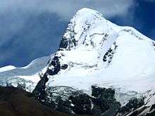 Kongur Tagh
 Kongur Tagh
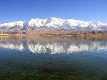
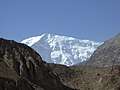 Gez Valley
.jpg)
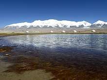
.jpg) Bulungkol Lake
Bulungkol Lake.jpg) Bulungkol Lake
Bulungkol Lake
Administrative divisions
The township has 5 administration villages.[5]
- Bulungkol (布伦口村)
- Gez (盖孜村)
- Qiakeraigele (恰克尔艾格勒村)
- Subashi (苏巴什村)
- Tuogayi (托喀依村)
- Unincorporated villages
- Qarjayit (恰尔加依特)
References
- 布伦口乡(概况). xjakt.gov.cn. 2018-06-04. Retrieved 2019-07-07.
- 布伦口的灯光. xjdaily.com.cn. 2019-07-06. Retrieved 2019-11-07.; 它是新疆的千湖之乡,境内的冰山和湖泊是著名的旅游胜地. baidu.com. 2018-08-03. Retrieved 2019-11-07.
- 阿克陶县行政区划和居民地名称. xjkz.gov.cn. 2018-05-04. Retrieved 2019-11-08.
- 布伦口乡(概况). qianxi123.com. 2018-08-12. Retrieved 2019-11-08.
- 2018年阿克陶县布伦口乡行政区划代码. National Bureau of Statistics of China. 2018-10-31. Retrieved 2019-11-07.