Qarlung
Qarlung (Chinese: 恰尔隆乡; pinyin: Qiàěrlóng Xiāng) is a township of Akto County in Xinjiang Uygur Autonomous Region, China. Located in the southeast of the county, the township covers an area of 3,242 square kilometers with a population of 5,258 (as of 2015[2]). It has 5 administrative villages under its jurisdiction. Its seat is at Jilande Village (吉郎德村).[3]
Qarlung 恰尔隆乡 Qiaerlong | |
|---|---|
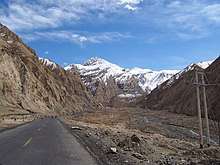
 Qarlung Location of the township | |
| Coordinates: 38.0321756817°N 75.9396119541°E | |
| Country | People's Republic of China |
| Autonomous region | Xinjiang |
| Prefecture | Kizilsu |
| County | Akto |
| Area | |
| • Total | 3,242 km2 (1,252 sq mi) |
| Population (2015) | |
| • Total | 5,258 |
| [2] | |
| Time zone | UTC+8 (China Standard Time) |
| postal code | 844100 |
| Area code(s) | 653022 203 |
| Website | www.xjakt.gov.cn |
Name
The name of Qarlung is from Turkic language, meaning "the place where the mountains gather" (群山汇集处). It is named after the confluence of the four narrow valleys.[2]
Geography and resources
Qarlung Township is located between 75°09′- 76°02′ east longitude and 37°52′- 38°12′ north latitude, to the south of the county seat Akto Town. It is bordered by Kizilto and Tar townships to the east and south, by Taxkorgan County to the west. Its maximum distance is 58 kilometers from west to east and 45 kilometers from north to south. It has a total area of 3,242 square meters with arable land area of 75.04 hectares and artificial grassland area of 77.89 hectares. The seat of the township is 210 kilometers away from Akto Town.
The annual average temperature is 1.9 ℃, the average temperature in January is -12.1 ℃, and the average temperature in July is 12.2 ℃. The annual precipitation is 150–200 mm, the frost-free period is 120 days.
There are precious animals such as snowcock, yellow sheep and argali in the territory, and mineral resources such as coal, crystal, gold, iron, lead and zinc. There are two water systems of Qarlung River (恰尔隆河) and the Kesrevati River (克斯热瓦提河), and the Pashrevati Yikbulak Hot Spring (帕什热瓦提依色克布拉克温泉) with a water temperature of 40-50 °C is a sulfur spring, which can help treat skin diseases.[4]
Administrative divisions
The township has 5 administration villages and unincorporated villages .[5]
- Jilande Village (吉郎德村)
- Kayiz Village (喀依孜村)
- Mazaoz Village (麻扎窝孜村)
- Paldalingoz Village (巴勒达灵窝孜村)
- Toylublung Village (托依鲁布隆村)
- Unincorporated villages
- Koyjol (阔依居勒)
- Janbulak (江布拉克)
References
- Total Area: 3,242 square meters; 2,203 square meters of the former Qarlung Township and 1,039 square meters of the former Kosrap Township (amalgated into Qarlung on August 27, 2018). see 2018年8月27日,自治区人民政府同意阿克陶县撤销库斯拉甫乡建制,原库斯拉甫乡整体搬迁至喀什地区泽普县大亚斯墩区域,原库斯拉甫乡行政区域划归阿克陶县恰尔隆乡管辖。 关于同意阿克陶县撤销库斯拉甫乡的批复(新政函[2018]149号). xjmca.gov.cn. 2018-09-04. Retrieved 2019-11-12.; 2018年8月27日,自治区人民政府同意泽普县设立桐安乡,乡人民政府驻英阿瓦提村,隶属泽普县管辖。 关于同意泽普县设立桐安乡的批复(新政函[2018]150号). xjmca.gov.cn. 2018-09-04. Retrieved 2019-11-12.
- 恰尔隆乡(概况). xjakt.gov.cn. 2018-06-04. Retrieved 2019-11-11.
- 阿克陶县行政区划和居民地名称. xjkz.gov.cn. 2018-05-04. Retrieved 2019-11-11.
- 克孜勒阿克陶县民生地理. monseng.com. 2019-03-04. Retrieved 2019-11-11.
- 2018年恰尔隆乡行政区划代码. National Bureau of Statistics of China. 2018-10-31. Retrieved 2019-11-11.