Wildwood, Missouri
| Wildwood, Missouri | ||
|---|---|---|
| City | ||
| ||
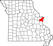
 Location of Wildwood, Missouri | ||
| Coordinates: 38°34′54″N 90°38′58″W / 38.58167°N 90.64944°WCoordinates: 38°34′54″N 90°38′58″W / 38.58167°N 90.64944°W | ||
| Country | United States | |
| State | Missouri | |
| County | St. Louis | |
| Government | ||
| • Mayor | Jim Bowlin | |
| Area[1] | ||
| • Total | 67.08 sq mi (173.74 km2) | |
| • Land | 66.42 sq mi (172.03 km2) | |
| • Water | 0.66 sq mi (1.71 km2) | |
| Elevation | 755 ft (230 m) | |
| Population (2010)[2] | ||
| • Total | 35,517 | |
| • Estimate (2017)[3] | 35,501 | |
| • Density | 530/sq mi (200/km2) | |
| Time zone | UTC−6 (Central (CST)) | |
| • Summer (DST) | UTC−5 (CDT) | |
| FIPS code | 29-79820[4] | |
| GNIS feature ID | 1699796[5] | |
| Website | www.cityofwildwood.com | |
Wildwood is an Upper Middle Classsuburb of St. Louis, located in far western St. Louis County, Missouri, United States. As of the 2010 census, the population was 35,517. In 2016, the median household income was $123,567.
Wildwood is the home of the Al Foster Trail,[6] and numerous other trails, parks, and reserves such as Rockwood and Babler State Park.
Geography
Wildwood is located at 38°34′54″N 90°38′58″W / 38.58167°N 90.64944°W (38.581653, -90.649427).[7]
According to the United States Census Bureau, the city has a total area of 67.08 square miles (173.74 km2), of which 66.42 square miles (172.03 km2) is land and 0.66 square miles (1.71 km2) is water.[1]
Wildwood is bounded on the north by Chesterfield; on the east by Clarkson Valley and Ellisville; on the south by Eureka and Pacific; and on the west by Franklin County.[8]
Demographics
| Historical population | |||
|---|---|---|---|
| Census | Pop. | %± | |
| 2000 | 32,884 | — | |
| 2010 | 35,517 | 8.0% | |
| Est. 2017 | 35,501 | [3] | 0.0% |
| U.S. Decennial Census | |||
2010 census
As of the census[2] of 2010, there were 35,517 people, 12,112 households, and 10,153 families residing in the city. The population density was 534.7 inhabitants per square mile (206.4/km2). There were 12,604 housing units at an average density of 189.8 per square mile (73.3/km2). The racial makeup of the city was 87.2% White, 6.7% African American, 0.2% Native American, 4.0% Asian, 0.4% from other races, and 1.5% from two or more races. Hispanic or Latino of any race were 2.3% of the population.
There were 12,112 households of which 45.4% had children under the age of 18 living with them, 75.2% were married couples living together, 6.0% had a female householder with no husband present, 2.6% had a male householder with no wife present, and 16.2% were non-families. 13.6% of all households were made up of individuals and 5% had someone living alone who was 65 years of age or older. The average household size was 2.93 and the average family size was 3.24.
The median age in the city was 41.5 years. 30.3% of residents were under the age of 18; 5.9% were between the ages of 18 and 24; 20.3% were from 25 to 44; 34.8% were from 45 to 64; and 8.9% were 65 years of age or older. The gender makeup of the city was 49.5% male and 50.5% female.
2000 census
As of the census[4] of 2000, there were 32,884 people, 10,837 households, and 9,243 families residing in the city. Estimated median house/condo value in 2005: $345,100. The population density was 498.0 people per square mile (192.3/km²). There were 11,229 housing units at an average density of 170.1 per square mile (65.7/km²). The racial makeup of the city was 94.74% White, 1.62% African American, 0.12% Native American, 2.38% Asian, 0.01% Pacific Islander, 0.29% from other races, and 0.83% from two or more races. Hispanic or Latino of any race were 1.38% of the population.
There were 10,837 households out of which 51.0% had children under the age of 18 living with them, 79.0% were married couples living together, 4.6% had a female householder with no husband present, and 14.7% were non-families. 12.4% of all households were made up of individuals and 4.0% had someone living alone who was 65 years of age or older. The average household size was 3.02 and the average family size was 3.32.
In the city, the population was spread out with 33.2% under the age of 18, 4.8% from 18 to 24, 31.4% from 25 to 44, 25.1% from 45 to 64, and 5.5% who were 65 years of age or older. The median age was 36 years. For every 100 females, there were 97.0 males. For every 100 females age 18 and over, there were 94.1 males.
Estimated median household income in 2007:[9] $113,270. Males had a median income of $75,849 versus $41,224 for females. The per capita income for the city was $38,485. About 1.6% of families and 2.2% of the population were below the poverty line, including 2.1% of those under age 18 and 5.4% of those age 65 or over.
Education
Wildwood is served by Rockwood School District with 1 high school within the city limits, Lafayette High School.
St. Louis Community College–Wildwood is a local 2 year public community college located off Route 100 and Route 109.
Police
The City of Wildwood contracts for police service with the St. Louis County Police Department.
Notable people
- David Freese, former third baseman for the St. Louis Cardinals, grew up in Wildwood and went to Rockwood Valley Middle School, then graduated from Lafayette High School in 2001. Freese's clutch play in the postseason helped the Cardinals win the 2011 National League pennant over the Milwaukee Brewers and the World Series over the Texas Rangers. Freese was honored by being named the 2011 NL Championship Series MVP and the 2011 World Series MVP.
- Ryan Howard, former first baseman for the Philadelphia Phillies, grew up in Wildwood and went to Lafayette High School.
- Luke Voit, baseball player
Culture
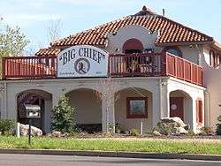
The Big Chief Restaurant is all that remains of a tourist complex that opened on U.S. Route 66 in 1928. It was added to the National Register of Historic Places listings in 2003.[10]
References
- 1 2 "US Gazetteer files 2010". United States Census Bureau. Archived from the original on 2011-06-28. Retrieved 2012-07-08.
- 1 2 "American FactFinder". United States Census Bureau. Retrieved 2012-07-08.
- 1 2 "City and Town Population Totals: 2010-2017". Retrieved May 26, 2018.
- 1 2 "American FactFinder". United States Census Bureau. Retrieved 2008-01-31.
- ↑ "US Board on Geographic Names". United States Geological Survey. 2007-10-25. Retrieved 2008-01-31.
- ↑ "Al Foster Trail".
- ↑ "US Gazetteer files: 2010, 2000, and 1990". United States Census Bureau. 2011-02-12. Retrieved 2011-04-23.
- ↑ "St. Louis County Interactive Maps". Archived from the original on 2010-04-23. Retrieved 2010-04-19.
- ↑ Bureau, U.S. Census. "American FactFinder - Community Facts". factfinder.census.gov. Retrieved 4 April 2018.
- ↑ "Big Chief Restaurant:Wildwood, Missouri". National Park Service. Retrieved April 6, 2017.
External links
| Topics |  | |
|---|---|---|
| Central city | ||
| Largest cities (over 50,000 in 2010) | ||
| Medium-sized cities (over 20,000 in 2010) | ||
| Largest towns and villages (over 10,000 in 2010) |
| |
| Missouri Counties | ||
| Illinois Counties | ||
| Subregions | ||
