Florissant, Missouri
| Florissant, Missouri | |||
|---|---|---|---|
| City | |||
.jpg) Florissant City Hall sign, April 2013 | |||
| |||
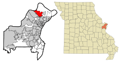 Location of Florissant, Missouri | |||
| Coordinates: 38°47′52″N 90°19′32″W / 38.79778°N 90.32556°WCoordinates: 38°47′52″N 90°19′32″W / 38.79778°N 90.32556°W | |||
| Country | United States | ||
| State | Missouri | ||
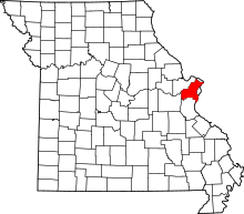
| County | St. Louis | ||
| Founded | 1785 | ||
| Government | |||
| • Mayor | Tom Schneider | ||
| • City Council |
List
| ||
| Area[1] | |||
| • Total | 12.87 sq mi (33.33 km2) | ||
| • Land | 12.56 sq mi (32.53 km2) | ||
| • Water | 0.31 sq mi (0.80 km2) | ||
| Elevation | 574 ft (175 m) | ||
| Population (2010)[2] | |||
| • Total | 52,158 | ||
| • Estimate (2017)[3] | 51,443 | ||
| • Density | 4,100/sq mi (1,600/km2) | ||
| Time zone | UTC-6 (Central (CST)) | ||
| • Summer (DST) | UTC-5 (CDT) | ||
| ZIP code | 63031, 63032, 63033, 63034 | ||
| Area code(s) | 314 | ||
| FIPS code | 29-24778[4] | ||
| GNIS feature ID | 0756063[5] | ||
| Website | http://www.florissantmo.com/ | ||

Florissant (/ˈflɒrɪsənt/ (![]()
History
The exact date the first settlers went to the Valley of Florissant is unknown, but it is one of the oldest settlements in the state of Missouri. Some historians believe it was settled about the same time as St. Louis. The first civil government was formed in 1786. Spanish archives in Havana reveal 40 people and seven plantations were in Florissant at the time of the 1787 census. The village, called "Fleurissant", or "Blooming" in English, by its French settlers and "St. Ferdinand" by its Spanish rulers, was a typical French village with its commons and common fields.[6] Originally a separate town, and now an inner suburb of St. Louis, the community was centered on (and frequently called after) the parish of St. Ferdinand. As late as 1889, the town was predominantly French-speaking (while the southern portion of the metropolis was populated by German-speakers).[7] The first train line to the area was constructed in 1878—an extension of the line which went from St. Louis City to Normandy.[8] The last train to Florissant ran on November 14, 1931.[8]
Following World War II, Florissant went from a small village community to a large suburban center, as developers such as Alfred H. Mayer Co. began building subdivisions on what was formerly farmland and empty acreage. Around 18,000 houses were built between 1947 and 1980, and the population swelled to its peak of about 76,000 in the mid-1970s, making it the largest city in St. Louis County.[8]
James J. Eagan was mayor of Florissant for 37 years from 1963 until his death on November 2, 2000. He was re-elected into office 9 times, and became one of the longest-serving mayors of any city in the United States. In his final year, he was awarded the title of Best Politician in St. Louis by the Riverfront Times.[9] The civic center off Parker Road is named the James J. Eagan Community Center in his memory.
In 2012, Florissant was ranked 76 in Money magazine's top-100 list of Best Places to Live – America's Best Small Cities.[10] In 2014, Florissant ranked as the #1 Best Small City to Retire To in America[11] and the second-safest city in Missouri.[12]
Geography
According to the United States Census Bureau, the city has a total area of 12.87 square miles (33.33 km2), of which 12.56 square miles (32.53 km2) are land and 0.31 square mile (0.80 km2) is covered by water.[1]
Demographics
.jpg)
| Historical population | |||
|---|---|---|---|
| Census | Pop. | %± | |
| 1880 | 817 | — | |
| 1890 | 769 | −5.9% | |
| 1900 | 752 | −2.2% | |
| 1910 | 765 | 1.7% | |
| 1920 | 682 | −10.8% | |
| 1930 | 1,039 | 52.3% | |
| 1940 | 1,369 | 31.8% | |
| 1950 | 3,737 | 173.0% | |
| 1960 | 38,166 | 921.3% | |
| 1970 | 65,908 | 72.7% | |
| 1980 | 55,372 | −16.0% | |
| 1990 | 51,206 | −7.5% | |
| 2000 | 50,497 | −1.4% | |
| 2010 | 52,158 | 3.3% | |
| Est. 2017 | 51,443 | [3] | −1.4% |
| U.S. Decennial Census | |||
2010 census
At the 2010 census,[2] there were 52,158 people, 21,247 households and 13,800 families residing in the city. The population density was 4,152.7 inhabitants per square mile (1,603.4/km2). There were 22,632 housing units at an average density of 1,801.9 per square mile (695.7/km2). The racial makeup of the city was 69.3% White, 26.8% African American, 0.2% Native American, 0.8% Asian, 0.6% from other races, and 2.3% from two or more races. Hispanic or Latino people of any race were 2.0% of the population.
There were 21,247 households of which 32.3% had children under the age of 18 living with them, 42.4% were married couples living together, 17.5% had a female householder with no husband present, 5.1% had a male householder with no wife present, and 35.0% were non-families. 29.9% of all households were made up of individuals and 12.2% had someone living alone who was 65 years of age or older. The average household size was 2.42 and the average family size was 3.00.
The median age in the city was 38 years. 23.9% of residents were under the age of 18; 8.6% were between the ages of 18 and 24; 26.2% were from 25 to 44; 25.8% were from 45 to 64; and 15.5% were 65 years of age or older. The gender makeup of the city was 46.8% male and 53.2% female.
2000 census
At the 2000 census,[4] there were 50,497 people, 20,399 households and 13,687 families residing in the city. The population density was 4,442.4 per square mile (1,714.8/km²). There were 21,027 housing units at an average density of 1,849.8 per square mile (714.0/km²). The racial makeup of the city was 86.66% White, 10.51% African American, 0.20% Native American, 0.61% Asian, 0.03% Pacific Islander, 0.52% from other races, and 1.48% from two or more races. Hispanic or Latino people of any race were 1.49% of the population.
There were 20,399 households of which 30.7% had children under the age of 18 living with them, 49.8% were married couples living together, 13.2% had a female householder with no husband present, and 32.9% were non-families. 28.8% of all households were made up of individuals and 12.3% had someone living alone who was 65 years of age or older. The average household size was 2.44 and the average family size was 3.01.
24.7% of the population were under the age of 18, 8.2% from 18 to 24, 29.9% from 25 to 44, 20.0% from 45 to 64, and 17.1% who were 65 years of age or older. The median age was 37 years. For every 100 females, there were 89.5 males. For every 100 females age 18 and over, there were 84.1 males.
The median household income was $44,462 and the median family income was $52,195. Males had a median income of $37,434 compared with $27,247 for females. The per capita income for the city was $20,622. About 2.7% of families and 4.0% of the population were below the poverty line, including 4.5% of those under age 18 and 3.7% of those age 65 or over.
Education
Public
Florissant is covered by the Hazelwood and Ferguson-Florissant public school districts. McCluer North High School and McCluer High School of the Ferguson-Florissant School District, and North Technical High School[13] are high schools in Florissant. Hazelwood Central is the only high school in Florissant belonging to the Hazelwood School District. Hazelwood Northwest Middle School and several elementary schools are within the limits.[14][15]
Private
North County Christian School is a pre-school to grade 12 Christian school that is theologically associated with the Church of the Nazarene.[16][17]
There are several kindergarten through 8th-grade parochial schools in Florissant. These include Atonement Lutheran School, Sacred Heart, St. Ferdinand, St. Rose Philippine Duchesne and Saint Norbert.[18]
Higher education
Florissant has two theological colleges, an extension campus, and a barber college. Saint Louis Christian College is a private, four-year, undergraduate institution that is theologically and ecclesiastically associated with the Christian churches and churches of Christ.[19] Urshan College (formerly Gateway College of Evangelism) and Urshan Graduate School of Theology are located at the former St. Stanislaus Jesuit seminary and are operated by the United Pentecostal Church International.[20][21] Lindenwood University has its offsite North County Campus located in the former Our Lady of Fatima School.[22] Missouri School of Barbering and Hairstyling-St Louis is also located in Florissant.[23]
Florissant Valley Community College and University of Missouri–St. Louis are located in close proximity to the city.
Public libraries
St. Louis County Library operates the Florissant Valley Branch in Florissant.[24][25]
Health care
Florissant is home to Northwest HealthCare, an outpatient subsidiary of Christian Hospital. Services include: emergency department, sleep lab, bone density testing, mammography, ultrasound and MRI.[26] A satellite facility of the Alvin J. Siteman Cancer Center that is under construction on the campus is scheduled to open in late 2019.[27]
Notable people
- Kate Capshaw, actress, wife of Steven Spielberg
- Leslie Coombs Brand, real estate developer; "father of Glendale, California"
- Cedric the Entertainer, comedian and actor
- Chingy, rapper
- Bob Christian, NFL running back
- Pierre-Jean De Smet, Catholic priest and missionary
- Rose Philippine Duchesne, Catholic nun and missionary declared a saint in 1988
- James J. Eagan, former mayor (1963–2000)
- Dennis Edwards, singer (The Contours, The Temptations)
- Shandi Finnessey, Miss Missouri USA 2004, Miss USA 2004, co-host of Lingo and PlayMania
- Robert G. Lowery, mayor (2000–2011)
- Jeremy Lucido, photographer
- Kathleen Madigan, comedian
- Kyle McClellan, Major League Baseball player
- Michael McDonald, singer-songwriter; formerly of the Doobie Brothers and Steely Dan
- Rita Meyer, All-American Girls Professional Baseball player
- Al Nipper, former Major League Baseball player
- Barry Orton, former professional wrestler
- "Cowboy" Bob Orton Jr, wrestler, WWE Hall of Fame
- Randy Orton, WWE wrestler
- Neil Rackers, NFL football player
- Bobby Rhine, Major League Soccer player
- Kerry Robinson, former Major League Baseball player
- Kimora Lee Simmons, retired supermodel, head of design for Baby Phat
- Mike Sorber, Major League Soccer player
- John A. Stormer, pseudo-conservative polemicist, author of None Dare Call It Treason
- Perry Van der Beck, soccer player and coach, North American Soccer League, Major Indoor Soccer League, National Professional Soccer League, former U.S. Soccer Athlete of the Year
- Ira Vandever, quarterback for the Stuttgart Scorpions in the German Football League
- Dick Weber, Hall of Fame bowler
- Pete Weber, Hall of Fame bowler
- Bill Wilkerson, sportscaster, radio host (KMOX)
- Bob Wiesler, former Major League Baseball player
- Clint Zweifel, State Treasurer of Missouri
References
- 1 2 "US Gazetteer files 2010". United States Census Bureau. Archived from the original on 2012-01-24. Retrieved 2012-07-08.
- 1 2 "American FactFinder". United States Census Bureau. Retrieved 2012-07-08.
- 1 2 "City and Town Population Totals: 2010-2017". Retrieved May 26, 2018.
- 1 2 "American FactFinder". United States Census Bureau. Archived from the original on 2013-09-11. Retrieved 2008-01-31.
- ↑ "US Board on Geographic Names". United States Geological Survey. 2007-10-25. Retrieved 2008-01-31.
- ↑ Old St. Ferdinand Shrine, Official Site
- ↑ St. Louis Post-Dispatch, January 27, 1889; cited in Missouri Historical Review, April 1957, p. 330
- 1 2 3 Wright Sr., John A. (June 7, 2004). Train Line. SC: Arcadia Publishing. ISBN 073853255X.
- ↑ Klose, Richard. "Best Politician St. Louis 2000". Riverfront Times. Retrieved 2014-03-14.
- ↑ Money Magazine Best Places 2012
- ↑ "These Are The 10 Best Small Cities To Retire To In America". Movoto.com. January 22, 2014.
- ↑ "Florissant Police Department Newsletter / Press Release" (PDF). Florissantmo/com. February 27, 2014.
- ↑ "North Technical High School". Archived from the original on March 2, 2008. Retrieved June 29, 2008.
- ↑ "Hazelwood School District Maps" (PDF). Hazelwood School District. Retrieved June 29, 2008.
- ↑ City of Florissant-Municipal Wards (Map) (August 2005 ed.). St. Louis County Department of Planning.
|access-date=requires|url=(help) - ↑ "About NCCS". North County Christian School. Archived from the original on June 19, 2006. Retrieved June 29, 2008.
- ↑ "Statement Of Beliefs". North County Christian School. Archived from the original on June 18, 2006. Retrieved June 29, 2008.
- ↑ "Parochial Schools of Missouri". National Parochial School Association. Retrieved June 29, 2008.
- ↑ "About SLCC". Saint Louis Christian College. Archived from the original on May 11, 2008. Retrieved June 29, 2008.
- ↑ urshancollege.org access date = May 27, 2017
- ↑ Urshan Graduate School of Theology accessdate =June 29, 2008
- ↑ "Lindenwood's Off-site Campuses - North County". Lindenwood University. Archived from the original on June 27, 2008. Retrieved June 29, 2008.
- ↑ "Missouri School of Barbering and Hairstyling-St Louis". Missouri Community Colleges. 50States.com. Retrieved June 29, 2008.
- ↑ "Florissant Valley Branch Archived 2009-08-23 at the Wayback Machine.." St. Louis County Library. Retrieved on August 18, 2009.
- ↑ "Florissant city, Missouri." U.S. Census Bureau. Retrieved on August 18, 2009.
- ↑ "Northwest HealthCare". Christian Hospital.
- ↑ Walker, Melody (31 July 2018). "North St. Louis County welcomes new Siteman Cancer Center". St. Louis Public Radio. Retrieved 14 August 2018.
Further reading
- Garraghan, Gilbert J. (1923). Saint Ferdinand de Florissant: the story of an ancient parish. Chicago: Loyola Univ. Press.
External links
| Topics |  | |
|---|---|---|
| Central city | ||
| Largest cities (over 50,000 in 2010) | ||
| Medium-sized cities (over 20,000 in 2010) | ||
| Largest towns and villages (over 10,000 in 2010) |
| |
| Missouri Counties | ||
| Illinois Counties | ||
| Subregions | ||
