Cahokia, Illinois
| Cahokia | |
|---|---|
| Village | |
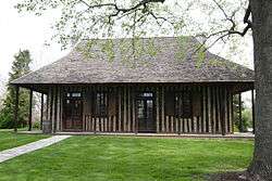 Old Cahokia Courthouse in Cahokia | |
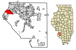 Location of Cahokia in Clair County, Illinois. | |
.svg.png) Location of Illinois in the United States | |
| Coordinates: 38°33′43″N 90°10′22″W / 38.56194°N 90.17278°WCoordinates: 38°33′43″N 90°10′22″W / 38.56194°N 90.17278°W | |
| Country | United States |
| State | Illinois |
| County | St. Clair |
| Government | |
| • Mayor | Curtis McCall Jr. |
| Area[1] | |
| • Total | 10.32 sq mi (26.72 km2) |
| • Land | 9.76 sq mi (25.28 km2) |
| • Water | 0.56 sq mi (1.44 km2) |
| Population (2010) | |
| • Total | 15,241 |
| • Estimate (2016)[2] | 14,260 |
| • Density | 1,460.77/sq mi (563.98/km2) |
| Time zone | UTC-6 (CST) |
| • Summer (DST) | UTC-5 (CDT) |
| Area code(s) | 618 |
| FIPS code | 17-10370 |
| Wikimedia Commons | Cahokia, Illinois |
| Website |
www |
Cahokia is a village in St. Clair County, Illinois, United States which is in the Greater St. Louis metropolitan area. As of the 2010 census, 15,241 people lived in the village, a decline from 16,391 in 2000.
The name refers to one of the clans of the historic Illini confederacy, who met early French explorers to the region. Early European settlers named the nearby (and long-abandoned) Cahokia Mounds in Madison County after the Illini clan, although the UNESCO World Heritage Site and State Historic Park actually reflects an extensive prehistoric Mississippian culture urban complex active from 900AD to 1500AD. French Canadians founded the village as a Catholic mission in 1696. The historic Church of the Holy Family (Cahokia) is the oldest continually active Catholic parish in the United States, as well as the oldest church west of the Allegheny mountains. Other significant colonial and Federal-period buildings listed on the National Register of Historic Places include the Cahokia Courthouse (c 1740, in the French Colonial style); and the Jarrot Mansion (c 1810).
History
Archeologists ascribe the earthwork mounds complex to the Mississippian culture, an earlier, potentially unrelated indigenous people. The city site reached its peak in the 13th century and was abandoned centuries before European contact. The Cahokia Native Americans of the Illini did not coalesce as a tribe and live in Illinois until nearly the time of French contact 300 years ago. Father Pinet founded a mission in late 1696 to convert the Cahokian and Tamaroa Native Americans to Christianity. Father Pinet and the Seminary of Foreign Missions of Quebec built a log church and dedicated it to the Holy Family.
During the next 100 years, Cahokia became one of the largest French colonial towns in the Illinois Country. Cahokia became centrally located for trading Indian goods and furs, and grew to about 3,000 inhabitants, as well as a thriving business district with 24 brothels. The nearby town of Kaskaskia on the Mississippi River (founded 1703) became the region's leading shipping port, and Fort de Chartres (founded 1718) developed into a military and governmental command center. The 50-mile (80 km) area of land between the two cities was cultivated by farming settlers, known as habitants, whose main crop was wheat. As the area expanded, the relationship between the settlers and the Indians continued peaceful. Settlers were mostly Canadien migrants whose families had been in North America for a while.
Cahokia declined after the French lost the French and Indian War in 1763, as part of the broader Seven Years' War in Europe, although only Fort Kaskaskia (built 1733) was destroyed in the conflict and Cahokia remained important regionally for another four decades. In the treaty ending the war, France ceded large parts of what it called the Illinois Country to the victors. Many French-speaking residents of Cahokia and elsewhere in what had been Upper Louisiana left rather than live under British rule. Many moved to Lower Louisiana, where they founded new Canadien villages on the west side of the Mississippi River, such as Ste. Genevieve, Missouri and St. Louis.
The Odawa leader Pontiac was assassinated by other Indians in or near Cahokia on April 20, 1769.

In 1778, during the American Revolutionary War, Virginian George Rogers Clark captured Kaskaskia and set up a court in Cahokia, making Cahokia an independent city state even though it was part of the British Province of Quebec. Cahokia (and Kaskaskia and the rest of Illinois County) officially became part of the United States by the Treaty of Paris (1783), by which the United States took over former British territory in what soon became known as the Northwest Territory(and after Ohio and Indiana became states, the Illinois Territory). Meanwhile, 105 Cahokia "heads of household" pledged loyalty to the Continental Congress of the United States.
After Congress passed the Northwest Ordinance in 1787 and established a governmental system for the territory, the Cahokia Courthouse became a United States territorial courthouse. Cahokia continued as a major political center for the next 24 years. Flood-prone Kaskaskia became the governmental seat of the Illinois Territory (1809-1819), until the territorial seat was moved to Vandalia, Illinois, and in 1809 became the county seat of Randolph County. Cahokia became the seat of St. Clair County, named by and after Arthur St. Clair, the first territorial governor. When St. Clair County was enlarged in 1801 and 1809, Governor William Henry Harrison (and later territorial secretary and acting governor Nathaniel Pope) named the Cahokia Courthouse the legal and governmental center of a sizeable area extending to the Canada–U.S. border. By 1814, other counties and territories had been organized, and St. Clair County became its current size. The county seat was moved to the more centrally located Belleville, Illinois (incorporated 1819 and as a city in 1850) when a local developer offered to donate land for a new county courthouse and seat.
In the late 1950s, Cahokia annexed some population and territory, increasing its population by more than 15,000 in 1960.
Geography
Cahokia is located at 38°33′43″N 90°10′22″W / 38.561901°N 90.172878°W.[3]
According to the 2010 census, Cahokia has a total area of 9.9 square miles (25.64 km2), of which 9.4 square miles (24.35 km2) (or 94.95%) is land and 0.5 square miles (1.29 km2) (or 5.05%) is water.[4]
Demographics
| Historical population | |||
|---|---|---|---|
| Census | Pop. | %± | |
| 1880 | 211 | — | |
| 1930 | 286 | — | |
| 1940 | 465 | 62.6% | |
| 1950 | 794 | 70.8% | |
| 1960 | 15,829 | 1,893.6% | |
| 1970 | 20,649 | 30.5% | |
| 1980 | 18,904 | −8.5% | |
| 1990 | 17,550 | −7.2% | |
| 2000 | 16,391 | −6.6% | |
| 2010 | 15,241 | −7.0% | |
| Est. 2016 | 14,260 | [2] | −6.4% |
| U.S. Decennial Census[5] | |||
As of the census[6] of 2000, there were 16,391 people, 5,693 households, and 4,252 families residing in the village. The population density was 1,705.8 people per square mile (658.5/km²). There were 6,213 housing units at an average density of 646.6 per square mile (249.6/km²). The racial makeup of the village was 58.28% African American, 38.69% White, 0.32% Native American, 0.38% Asian, 0.03% Pacific Islander, 0.73% from other races, and 1.56% from two or more races. Hispanic or Latino of any race were 2.25% of the population.
There were 5,693 households out of which 41.2% had children under the age of 18 living with them, 43.2% were married couples living together, 25.7% had a female householder with no husband present, and 25.3% were non-families. 20.9% of all households were made up of individuals and 8.6% had someone living alone who was 65 years of age or older. The average household size was 2.84 and the average family size was 3.27.
In the village, the population was spread out with 33.4% under the age of 18, 8.7% from 18 to 24, 29.4% from 25 to 44, 16.9% from 45 to 64, and 11.6% who were 65 years of age or older. The median age was 31 years. For every 100 females, there were 88.7 males. For every 100 females age 18 and over, there were 82.5 males.
The median income for a household in the village was $31,001, and the median income for a family was $35,582. Males had a median income of $31,806 versus $22,429 for females. The per capita income for the village was $14,545. About 22.8% of families and 24.9% of the population were below the poverty line, including 37.0% of those under age 18 and 5.3% of those age 65 or over.
Transportation
Cahokia is home to the St. Louis Downtown Airport, a general aviation facility.
Education
Cahokia Unit School District 187 operates public schools.
See also
- Battle of St. Louis (of 1780, during the American Revolutionary War)
References
- ↑ "2016 U.S. Gazetteer Files". United States Census Bureau. Retrieved Jun 29, 2017.
- 1 2 "Population and Housing Unit Estimates". Retrieved June 9, 2017.
- ↑ "US Gazetteer files: 2010, 2000, and 1990". United States Census Bureau. 2011-02-12. Retrieved 2011-04-23.
- ↑ "G001 - Geographic Identifiers - 2010 Census Summary File 1". United States Census Bureau. Retrieved 2015-08-02.
- ↑ "Census of Population and Housing". Census.gov. Archived from the original on April 22, 2013. Retrieved June 4, 2015.
- ↑ "American FactFinder". United States Census Bureau. Archived from the original on 2013-09-11. Retrieved 2008-01-31.
Further reading
- Reed, Denita. Cahokia (Images of America). Arcadia Publishing, 1998. ISBN 0738589977, 9780738589978.
External links
| Counties |  | |
|---|---|---|
| Major Cities (25,000+) | ||
| Cities (5,000-25,000) | ||
| Communities (1,000-5,000) |
| |
| Interstates | ||
| Airports | ||
| Colleges | ||
| Sports teams |
| |
Municipalities and communities of St. Clair County, Illinois, United States | ||
|---|---|---|
| Cities | ||
| Villages | ||
| Townships | ||
| CDPs | ||
| Other unincorporated communities | ||
| Footnotes | ‡This populated place also has portions in an adjacent county or counties | |
| Topics | 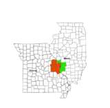 | |
|---|---|---|
| Central city | ||
| Largest cities (over 50,000 in 2010) | ||
| Medium-sized cities (over 20,000 in 2010) | ||
| Largest towns and villages (over 10,000 in 2010) |
| |
| Missouri Counties | ||
| Illinois Counties | ||
| Subregions | ||
| Counties |  | |
|---|---|---|
| Mid-sized cities (25,000+) | ||
| Small Cities (10,000-25,000) | ||
| Small Cities (5,000-10,000) | ||
| Interstates | ||
| Airports/Military bases |
| |
| Universities | ||
| Colleges | ||
| Sports teams based in the Southern Illinois | ||
| Authority control |
|---|