Douglas County, Missouri
| Douglas County, Missouri | |
|---|---|
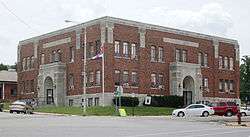 Douglas County courthouse in Ava | |
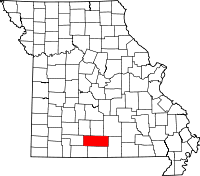 Location in the U.S. state of Missouri | |
 Missouri's location in the U.S. | |
| Founded | October 19, 1857 |
| Named for | Stephen A. Douglas |
| Seat | Ava |
| Largest city | Ava |
| Area | |
| • Total | 815 sq mi (2,111 km2) |
| • Land | 814 sq mi (2,108 km2) |
| • Water | 1.0 sq mi (3 km2), 0.1% |
| Population (est.) | |
| • (2015) | 13,373 |
| • Density | 17/sq mi (7/km2) |
| Congressional district | 8th |
| Time zone | Central: UTC−6/−5 |
Douglas County is a county located in the south-central portion of the U.S. state of Missouri. As of the 2010 census, the population was 13,684.[1] The county seat and only incorporated community is Ava.[2] The county was officially organized on October 19, 1857,[3] and is named after U.S. Senator Stephen A. Douglas[4] (D-Illinois) and later Democratic presidential candidate.
History
Previously, the county seat was located at Arno, west of Ava. Prior to that, Vera Cruz (formerly called Red Bud) was the county seat. Vera Cruz is located on Bryant Creek, which flows through the middle of the county. The Civil War Battle of Clark's Mill took place near Vera Cruz on November 7, 1862 and resulted in a Confederate victory.[5] After the American Civil War, during a period of general chaos, a group from the western part of the county broke into the Arno courthouse and removed the records back to Vera Cruz. Later in 1871, a new town site was selected, present-day Ava, near the location of the former U.S. Civil War military Post Office, Militia Spring. The location of this new town seemed to satisfy most of the residents of Douglas County to be their point of county government.
Geography
According to the U.S. Census Bureau, the county has a total area of 815 square miles (2,110 km2), of which 814 square miles (2,110 km2) is land and 1.0 square mile (2.6 km2) (0.1%) is water.[6]
Adjacent counties
- Webster County (northwest)
- Wright County (north)
- Texas County (northeast)
- Howell County (east)
- Ozark County (south)
- Taney County (southwest)
- Christian County (west)
Major highways

National protected area
- Mark Twain National Forest (part)
Demographics
| Historical population | |||
|---|---|---|---|
| Census | Pop. | %± | |
| 1860 | 2,414 | — | |
| 1870 | 3,915 | 62.2% | |
| 1880 | 7,753 | 98.0% | |
| 1890 | 14,111 | 82.0% | |
| 1900 | 16,802 | 19.1% | |
| 1910 | 16,664 | −0.8% | |
| 1920 | 15,436 | −7.4% | |
| 1930 | 13,959 | −9.6% | |
| 1940 | 15,600 | 11.8% | |
| 1950 | 12,638 | −19.0% | |
| 1960 | 9,653 | −23.6% | |
| 1970 | 9,268 | −4.0% | |
| 1980 | 11,594 | 25.1% | |
| 1990 | 11,876 | 2.4% | |
| 2000 | 13,084 | 10.2% | |
| 2010 | 13,684 | 4.6% | |
| Est. 2016 | 13,358 | [7] | −2.4% |
| U.S. Decennial Census[8] 1790-1960[9] 1900-1990[10] 1990-2000[11] 2010-2015[1] | |||
As of the census[12] of 2000, there were 13,084 people, 5,201 households, and 3,671 families residing in the county. The population density was 16 people per square mile (6/km²). There were 5,919 housing units at an average density of 7 per square mile (3/km²). The racial makeup of the county was 96.86% White, 0.11% Black or African American, 0.95% Native American, 0.21% Asian, 0.02% Pacific Islander, 0.17% from other races, and 1.69% from two or more races. Approximately 0.84% of the population were Hispanic or Latino of any race. Among the major first ancestries reported in Douglas County are 31.3% American, 13.2% English, 12.3% German, and 9.7% Irish.
There were 5,201 households out of which 30.10% had children under the age of 18 living with them, 60.00% were married couples living together, 7.20% had a female householder with no husband present, and 29.40% were non-families. 26.10% of all households were made up of individuals and 13.00% had someone living alone who was 65 years of age or older. The average household size was 2.49 and the average family size was 2.99.
In the county, the population was spread out with 25.80% under the age of 18, 7.00% from 18 to 24, 24.50% from 25 to 44, 25.60% from 45 to 64, and 17.10% who were 65 years of age or older. The median age was 40 years. For every 100 females there were 96.60 males. For every 100 females age 18 and over, there were 93.30 males.
The median income for a household in the county was $31,335, and the median income for a family was $36,648. Males had a median income of $22,706 versus $17,060 for females. The per capita income for the county was $16,710. About 12.90% of families and 17.50% of the population were below the poverty line, including 19.80% of those under age 18 and 18.20% of those age 65 or over.
Religion
According to the Association of Religion Data Archives County Membership Report (2000), Douglas County is a part of the Bible Belt with evangelical Protestantism being the majority religion. The most predominant denominations among residents in Douglas County who adhere to a religion are Southern Baptists (22.95%), Church of the Nazarene (16.28%), and Mormons (13.70%).
Established in 1950, a Trappist monastery, Assumption Abbey, can be found nestled on 3,000 acres in the Ozark hills. An associated Friary, Our Lady of the Angels, is located nearby. Both facilities have overnight rooms available to be utilized by the public for a small fee in order to find a place of solace and quiet reflection.
Education
Of adults 25 years of age and older in Douglas County, 69.7% possess a high school diploma or higher while 9.9% hold a bachelor's degree or higher as their highest educational attainment.
Public schools
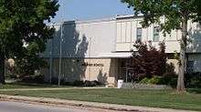
- Ava R-I School District - Ava
- Ava Elementary School (PK-04)
- Ava Middle School (05-08)
- Ava High School (09-12)
- Plainview R8 School District - Goodhope, Missouri
- Plainview Elementary School (K-08) - West of Ava
- Skyline R2 School District - Norwood, Missouri
- Skyline Elementary (K-08)
Private schools
- Mt. Zion Bible Academy - Ava - (PK-12) - Church of God
Public libraries
- Douglas County Public Library[13]
Politics
Local
| Douglas County, Missouri | ||||
|---|---|---|---|---|
| Elected countywide officials | ||||
| Assessor | Alicia Miller-Degase | Republican | ||
| Circuit Clerk | Kim Hathcock | Republican | ||
| County Clerk | Karry Davis | Republican | ||
| Collector | Laura Stillings | Republican | ||
| Commissioner (Presiding) |
Larry Pueppke | Republican | ||
| Commissioner (District 1) |
Richard Mitchell | Republican | ||
| Commissioner (District 2) |
Danny Dry | Republican | ||
| Coroner | Rick Miller | Republican | ||
| Prosecuting Attorney | Roger Wall | Republican | ||
| Public Administrator | Linda Coonts | Republican | ||
| Recorder | Tina Boyd | Republican | ||
| Sheriff | Chris Degase | Republican | ||
| Surveyor | Andy Daniels | Democrat | ||
| Treasurer | Theresa Miller | Republican | ||
The Republican party holds most of the elected positions in the county. But it has not always been so. In the early 1900's Douglas County was primarily Democratic.
State
| Year | Republican | Democratic | Third Parties |
|---|---|---|---|
| 2016 | 72.34% 4,818 | 24.13% 1,607 | 3.53% 235 |
| 2012 | 59.43% 3,869 | 36.97% 2,407 | 3.59% 234 |
| 2008 | 45.27% 3,014 | 48.95% 3,259 | 5.78% 385 |
| 2004 | 70.08% 4,412 | 28.40% 1,788 | 1.52% 96 |
| 2000 | 63.53% 3,317 | 34.73% 1,813 | 1.74% 91 |
| 1996 | 61.03% 3,145 | 36.06% 1,858 | 2.91% 150 |
| 1992 | 57.14% 3,203 | 42.86% 2,403 | 0.00% 0 |
| 1988 | 74.63% 3,671 | 24.90% 1,225 | 0.47% 23 |
| 1984 | 75.00% 3,846 | 25.00% 1,282 | 0.00% 0 |
| 1980 | 60.76% 3,151 | 38.78% 2,011 | 0.46% 24 |
| 1976 | 63.51% 2,924 | 36.21% 1,667 | 0.28% 13 |
| 1972 | 67.00% 3,350 | 32.90% 1,645 | 0.10% 5 |
| 1968 | 59.75% 2,420 | 40.25% 1,630 | 0.00% 0 |
| 1964 | 58.64% 2,217 | 41.16% 1,551 | 0.00% 0 |
| 1960 | 73.68% 3,242 | 26.32% 1,158 | 0.00% 0 |
All of Douglas County is a part of Missouri’s 155th District and is currently represented in the Missouri House of Representatives by Lyle Rowland, (R-Cedar Creek.
| Party | Candidate | Votes | % | ± | |
|---|---|---|---|---|---|
| Republican | Lyle Rowland | 5,641 | 100.00% | ||
| Party | Candidate | Votes | % | ± | |
|---|---|---|---|---|---|
| Republican | Lyle Rowland | 2,424 | 100.00% | ||
| Party | Candidate | Votes | % | ± | |
|---|---|---|---|---|---|
| Republican | Lyle Rowland | 5,360 | 100.00% | ||
All of Douglas County is a part of Missouri’s 33rd District and is currently represented in the Missouri Senate by Mike Cunningham (R-Rogersville).
| Party | Candidate | Votes | % | ± | |
|---|---|---|---|---|---|
| Republican | Mike Cunningham | 5,713 | 100.00% | ||
| Party | Candidate | Votes | % | ± | |
|---|---|---|---|---|---|
| Republican | Mike Cunningham | 5,478 | 100.00% | ||
Federal
Missouri's two U.S. Senators are Democrat Claire McCaskill of Kirkwood and Republican Roy Blunt of Strafford.
| Party | Candidate | Votes | % | ± | |
|---|---|---|---|---|---|
| Republican | Roy Blunt | 4,753 | 71.31% | +17.76 | |
| Democratic | Jason Kander | 1,556 | 23.35% | -14.71 | |
| Libertarian | Jonathan Dine | 174 | 2.61% | -5.78 | |
| Green | Johnathan McFarland | 81 | 1.22% | +1.22 | |
| Constitution | Fred Ryman | 101 | 1.52% | +1.52 | |
| Party | Candidate | Votes | % | ± | |
|---|---|---|---|---|---|
| Republican | W. Todd Akin | 3,498 | 53.55% | ||
| Democratic | Claire McCaskill | 2,486 | 38.06% | ||
| Libertarian | Jonathan Dine | 548 | 8.39% | ||
All of Douglas County is included in Missouri's 8th Congressional District and is currently represented by Jason T. Smith of Salem in the U.S. House of Representatives. Smith won a special election on Tuesday, June 4, 2013, to complete the remaining term of former U.S. Representative Jo Ann Emerson of Cape Girardeau. Emerson announced her resignation a month after being reelected with over 70 percent of the vote in the district. She resigned to become CEO of the National Rural Electric Cooperative.
| Party | Candidate | Votes | % | ± | |
|---|---|---|---|---|---|
| Republican | Jason T. Smith | 5,313 | 82.31% | +7.76 | |
| Democratic | Dave Cowell | 944 | 14.62% | -1.07 | |
| Libertarian | Jonathan Shell | 198 | 3.07% | +0.59 | |
| Party | Candidate | Votes | % | ± | |
|---|---|---|---|---|---|
| Republican | Jason T. Smith | 2,133 | 74.55% | -0.67 | |
| Democratic | Barbara Stocker | 449 | 15.69% | -2.54 | |
| Libertarian | Rick Vandeven | 71 | 2.48% | +0.84 | |
| Constitution | Doug Enyart | 64 | 2.24% | -2.67 | |
| Independent | Terry Hampton | 144 | 5.03% | +5.03 | |
| Party | Candidate | Votes | % | ± | |
|---|---|---|---|---|---|
| Republican | Jason T. Smith | 1,011 | 75.22% | -2.20 | |
| Democratic | Steve Hodges | 245 | 18.23% | +0.75 | |
| Libertarian | Bill Slantz | 22 | 1.64% | -3.45 | |
| Constitution | Doug Enyart | 66 | 4.91% | +4.91 | |
| Party | Candidate | Votes | % | ± | |
|---|---|---|---|---|---|
| Republican | Jo Ann Emerson | 4,942 | 77.42% | ||
| Democratic | Jack Rushin | 1,116 | 17.48% | ||
| Libertarian | Rick Vandeven | 325 | 5.09% | ||
Political culture
| Year | Republican | Democratic | Third parties |
|---|---|---|---|
| 2016 | 82.3% 5,486 | 14.8% 984 | 2.9% 196 |
| 2012 | 70.9% 4,649 | 26.1% 1,710 | 3.0% 198 |
| 2008 | 65.6% 4,405 | 31.9% 2,140 | 2.5% 167 |
| 2004 | 71.1% 4,498 | 27.5% 1,741 | 1.4% 88 |
| 2000 | 68.2% 3,599 | 29.3% 1,546 | 2.6% 136 |
| 1996 | 50.2% 2,601 | 33.6% 1,744 | 16.2% 839 |
| 1992 | 44.4% 2,569 | 36.7% 2,126 | 18.9% 1,097 |
| 1988 | 64.9% 3,225 | 34.9% 1,735 | 0.3% 13 |
| 1984 | 70.5% 3,662 | 29.6% 1,536 | |
| 1980 | 65.5% 3,440 | 31.9% 1,677 | 2.6% 135 |
| 1976 | 56.8% 2,652 | 42.5% 1,981 | 0.7% 34 |
| 1972 | 75.7% 3,773 | 24.3% 1,209 | |
| 1968 | 67.1% 2,836 | 23.1% 978 | 9.8% 412 |
| 1964 | 58.9% 2,280 | 41.1% 1,593 | |
| 1960 | 78.1% 3,611 | 21.9% 1,014 | |
| 1956 | 72.0% 2,910 | 28.0% 1,133 | |
| 1952 | 81.5% 4,051 | 18.3% 909 | 0.2% 11 |
| 1948 | 69.9% 2,734 | 29.7% 1,163 | 0.4% 17 |
| 1944 | 82.5% 3,570 | 17.2% 746 | 0.3% 14 |
| 1940 | 77.9% 4,870 | 21.6% 1,350 | 0.5% 32 |
| 1936 | 65.2% 4,031 | 34.2% 2,118 | 0.6% 38 |
| 1932 | 53.5% 2,362 | 43.5% 1,922 | 3.0% 131 |
| 1928 | 84.0% 3,758 | 15.2% 681 | 0.8% 35 |
| 1924 | 69.2% 2,617 | 24.0% 909 | 6.8% 258 |
| 1920 | 82.1% 3,327 | 14.2% 577 | 3.7% 149 |
| 1916 | 65.3% 1,730 | 27.8% 737 | 6.9% 184 |
| 1912 | 30.6% 855 | 20.2% 566 | 49.2% 1,377 |
| 1908 | 64.8% 1,922 | 23.6% 699 | 11.6% 343 |
| 1904 | 71.9% 1,830 | 17.2% 437 | 10.9% 278 |
| 1900 | 57.7% 1,705 | 29.1% 858 | 13.2% 391 |
| 1896 | 48.3% 1,598 | 51.4% 1,700 | 0.3% 9 |
| 1892 | 53.2% 1,309 | 13.3% 328 | 33.4% 822 |
| 1888 | 54.0% 1,306 | 19.7% 477 | 26.2% 634 |
Douglas County is, like most other counties located in the GOP bastion of Southwest Missouri, a Republican stronghold in presidential elections. No Democratic presidential nominee has won Douglas County since William Jennings Bryan in 1896, and no other nominee has done so since 1864.[15] While statewide elections tend to be closer throughout the state, this is not the case in Douglas County, as no Democratic gubernatorial nominee had won the county in over 50 years until Governor Jay Nixon's narrow pluralistic win in 2008. Furthermore, with all local elected offices being held by Republicans, voters have kept the traditionally Republican dominance alive in Douglas County.
Like most rural areas throughout the Bible Belt in Southwest Missouri, voters in Douglas County traditionally adhere to socially and culturally conservative principles which tend to strongly influence their Republican leanings. In 2004, Missourians voted on a constitutional amendment to define marriage as the union between a man and a woman—it overwhelmingly passed Douglas County with 85.78 percent of the vote. The initiative passed the state with 71 percent of support from voters as Missouri became the first state to ban same-sex marriage. In 2006, Missourians voted on a constitutional amendment to fund and legalize embryonic stem cell research in the state—it failed in Douglas County with 59.36 percent voting against the measure. The initiative narrowly passed the state with 51 percent of support from voters as Missouri became one of the first states in the nation to approve embryonic stem cell research. Despite Douglas County’s longstanding tradition of supporting socially conservative platforms, voters in the county have a penchant for advancing populist causes like increasing the minimum wage. In 2006, Missourians voted on a proposition (Proposition B) to increase the minimum wage in the state to $6.50 an hour—it passed Douglas County with 71.97 percent of the vote. The proposition strongly passed every single county in Missouri with 78.99 percent voting in favor as the minimum wage was increased to $6.50 an hour in the state. During the same election, voters in five other states also strongly approved increases in the minimum wage.
Missouri presidential preference primary (2008)
| Douglas County, Missouri | |
|---|---|
| 2008 Republican primary in Missouri | |
| John McCain | 516 (21.15%) |
| Mike Huckabee | 1,343 (55.04%) |
| Mitt Romney | 270 (11.07%) |
| Ron Paul | 290 (12.09%) |
| Douglas County, Missouri | |
|---|---|
| 2008 Democratic primary in Missouri | |
| Hillary Clinton | 827 (62.32%) |
| Barack Obama | 454 (34.21%) |
| John Edwards (withdrawn) | 39 (2.94%) |
In the 2008 Missouri Presidential Preference Primary, voters in Douglas County from both political parties supported candidates who finished in second place in the state at large and nationally.
- Former Governor Mike Huckabee (R-Arkansas) received more votes, a total of 1,343, than any candidate from either party in Douglas County during the 2008 Missouri Presidential Primaries. He also received 16 more votes than the total number of votes cast in the entire Democratic Primary in Douglas County.
Communities
The county has only one incorporated town: Ava, the county seat. Also, a number of current and historic communities are present:[16][17]
- Ann
- Arden
- Arno
- Ava
- Basher
- Bertha
- Blanche
- Brushyknob
- Bryant
- Buckhart
- Champion
- Coldspring
- Cross Roads
- Denlow
- Dogwood
- Drury
- Evans
- Gentryville
- Girdner
- Goodhope
- Hebron
- Jackson Mill
- Merritt
- Midway
- Mount Zion
- Olathia
- Ongo
- Redbank
- Rippee
- Rome
- Roosevelt
- Roy
- Smallett
- Squires
- Sweden
- Tigris
- Topaz
- Vanzant
- Vera Cruz
See also
References
- 1 2 "State & County QuickFacts". United States Census Bureau. Archived from the original on July 9, 2011. Retrieved September 8, 2013.
- ↑ "Find a County". National Association of Counties. Archived from the original on 2011-05-31. Retrieved 2011-06-07.
- ↑ Eaton, David Wolfe (1916). How Missouri Counties, Towns and Streams Were Named. The State Historical Society of Missouri. p. 165.
- ↑ Gannett, Henry (1905). The Origin of Certain Place Names in the United States. Govt. Print. Off. p. 108.
- ↑ U.S. National Park Service CWSAC Battle Summary Archived 2008-09-24 at the Wayback Machine.
- ↑ "2010 Census Gazetteer Files". United States Census Bureau. August 22, 2012. Archived from the original on July 9, 2013. Retrieved November 15, 2014.
- ↑ "Population and Housing Unit Estimates". Retrieved June 9, 2017.
- ↑ "U.S. Decennial Census". United States Census Bureau. Archived from the original on May 12, 2015. Retrieved November 15, 2014.
- ↑ "Historical Census Browser". University of Virginia Library. Retrieved November 15, 2014.
- ↑ "Population of Counties by Decennial Census: 1900 to 1990". United States Census Bureau. Retrieved November 15, 2014.
- ↑ "Census 2000 PHC-T-4. Ranking Tables for Counties: 1990 and 2000" (PDF). United States Census Bureau. Retrieved November 15, 2014.
- ↑ "American FactFinder". United States Census Bureau. Archived from the original on 2013-09-11. Retrieved 2008-01-31.
- ↑ Breeding, Marshall. "Douglas County Public Library". Libraries.org. Retrieved May 8, 2017.
- ↑ Leip, David. "Dave Leip's Atlas of U.S. Presidential Elections". uselectionatlas.org. Retrieved 2018-03-25.
- ↑ Menendez, Albert J.; The Geography of Presidential Elections in the United States, 1868-2004, pp. 31, 239 ISBN 0786422173
- ↑ Moser, Arthur Paul; A Directory of Towns, Villages, and Hamlets Past and Present of Douglas County, Missouri
- ↑ Post Offices in Douglas County, MO
Further reading
External links
- Digitized 1930 Plat Book of Douglas County from University of Missouri Division of Special Collections, Archives, and Rare Books
- https://www.webcitation.org/603P4GCda?url=http://quickfacts.census.gov/qfd/states/29/29067.html
Coordinates: 36°56′N 92°30′W / 36.93°N 92.50°W
Places adjacent to Douglas County, Missouri | ||||||||||
|---|---|---|---|---|---|---|---|---|---|---|
| ||||||||||
Municipalities and communities of Douglas County, Missouri, United States | ||
|---|---|---|
| City | | |
| Townships |
| |
| Unincorporated communities | ||
| Ghost towns | ||
