Moline Acres, Missouri
| Moline Acres, Missouri | |
|---|---|
| City | |
.jpg) Lewis & Clark Towers, an abandoned apartment building in Moline Acres, April 2013 | |
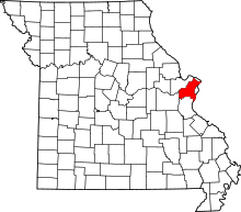
 Location of Moline Acres, Missouri | |
| Coordinates: 38°44′47″N 90°14′34″W / 38.74639°N 90.24278°WCoordinates: 38°44′47″N 90°14′34″W / 38.74639°N 90.24278°W | |
| Country | United States |
| State | Missouri |
| County | St. Louis |
| Government | |
| • Mayor | Michele DeShay |
| Area[1] | |
| • Total | 0.57 sq mi (1.48 km2) |
| • Land | 0.57 sq mi (1.48 km2) |
| • Water | 0 sq mi (0 km2) |
| Elevation | 479 ft (146 m) |
| Population (2010)[2] | |
| • Total | 2,442 |
| • Estimate (2016)[3] | 2,406 |
| • Density | 4,300/sq mi (1,700/km2) |
| Time zone | UTC-6 (Central (CST)) |
| • Summer (DST) | UTC-5 (CDT) |
| ZIP code | 63136, 63137 |
| Area code(s) | 314 |
| FIPS code | 29-49088[4] |
| GNIS feature ID | 0756402[5] |
Moline Acres is a city in St. Louis County, Missouri, United States. The population was 2,442 at the 2010 census.[6]
Geography
Moline Acres is located at 38°44′47″N 90°14′34″W / 38.74639°N 90.24278°W (38.746483, -90.242838).[7]
According to the United States Census Bureau, the city has a total area of 0.57 square miles (1.48 km2), all of it land.[1]
Demographics
| Historical population | |||
|---|---|---|---|
| Census | Pop. | %± | |
| 1950 | 99 | — | |
| 1960 | 3,132 | 3,063.6% | |
| 1970 | 3,722 | 18.8% | |
| 1980 | 2,774 | −25.5% | |
| 1990 | 2,710 | −2.3% | |
| 2000 | 2,662 | −1.8% | |
| 2010 | 2,442 | −8.3% | |
| Est. 2016 | 2,406 | [3] | −1.5% |
| U.S. Decennial Census[8] | |||
2010 census
As of the census[2] of 2010, there were 2,442 people, 942 households, and 643 families residing in the city. The population density was 4,284.2 inhabitants per square mile (1,654.1/km2). There were 1,043 housing units at an average density of 1,829.8 per square mile (706.5/km2). The racial makeup of the city was 6.3% White, 92.1% African American, 0.2% Native American, 0.2% from other races, and 1.1% from two or more races. Hispanic or Latino of any race were 0.8% of the population.
There were 942 households of which 36.6% had children under the age of 18 living with them, 26.8% were married couples living together, 35.0% had a female householder with no husband present, 6.5% had a male householder with no wife present, and 31.7% were non-families. 28.6% of all households were made up of individuals and 9.7% had someone living alone who was 65 years of age or older. The average household size was 2.59 and the average family size was 3.16.
The median age in the city was 37.4 years. 27.1% of residents were under the age of 18; 9% were between the ages of 18 and 24; 23.2% were from 25 to 44; 28.2% were from 45 to 64; and 12.5% were 65 years of age or older. The gender makeup of the city was 42.8% male and 57.2% female.
2000 census
As of the census[4] of 2000, there were 2,662 people, 1,001 households, and 691 families residing in the city. The population density was 4,720.6 people per square mile (1,835.4/km²). There were 1,047 housing units at an average density of 1,856.7 per square mile (721.9/km²). The racial makeup of the city was 12.17% White, 85.54% African American, 0.04% Native American, 0.26% Asian, 0.04% Pacific Islander, 0.26% from other races, and 1.69% from two or more races. Hispanic or Latino of any race were 0.30% of the population.
There were 1,001 households out of which 35.6% had children under the age of 18 living with them, 34.5% were married couples living together, 30.5% had a female householder with no husband present, and 30.9% were non-families. 27.9% of all households were made up of individuals and 8.4% had someone living alone who was 65 years of age or older. The average household size was 2.66 and the average family size was 3.24.
In the city, the population was spread out with 30.4% under the age of 18, 9.0% from 18 to 24, 26.2% from 25 to 44, 24.1% from 45 to 64, and 10.2% who were 65 years of age or older. The median age was 34 years. For every 100 females, there were 77.5 males. For every 100 females age 18 and over, there were 72.8 males.
The median income for a household in the city was $32,229, and the median income for a family was $34,663. Males had a median income of $25,703 versus $26,467 for females. The per capita income for the city was $12,739. About 16.7% of families and 19.4% of the population were below the poverty line, including 25.1% of those under age 18 and 14.8% of those age 65 or over.
Education
The St. Louis County Library Lewis and Clark Branch is located in Moline Acres.[9][10]
References
- 1 2 "US Gazetteer files 2010". United States Census Bureau. Archived from the original on 2012-07-14. Retrieved 2012-07-08.
- 1 2 "American FactFinder". United States Census Bureau. Retrieved 2012-07-08.
- 1 2 "Population and Housing Unit Estimates". Retrieved June 9, 2017.
- 1 2 "American FactFinder". United States Census Bureau. Retrieved 2008-01-31.
- ↑ "US Board on Geographic Names". United States Geological Survey. 2007-10-25. Retrieved 2008-01-31.
- ↑ "Race, Hispanic or Latino, Age, and Housing Occupancy: 2010 Census Redistricting Data (Public Law 94-171) Summary File (QT-PL), Moline Acres city, Missouri". U.S. Census Bureau, American FactFinder 2. Retrieved October 24, 2011.
- ↑ "US Gazetteer files: 2010, 2000, and 1990". United States Census Bureau. 2011-02-12. Retrieved 2011-04-23.
- ↑ "Census of Population and Housing". Census.gov. Retrieved June 4, 2015.
- ↑ "Lewis and Clark Branch Archived 2009-08-31 at the Wayback Machine.." St. Louis County Library. Retrieved on August 18, 2009.
- ↑ "Moline Acres city, Missouri." U.S. Census Bureau. Retrieved on August 18, 2009.