Geography
According to the U.S. Census Bureau, the county has a total area of 496 square miles (1,280 km2), of which 685 square miles (1,770 km2) is land and 5.6 square miles (15 km2) (0.8%) is water.[5] The Missouri River makes up the southern border of the county.
Demographics
| Historical population |
| Census | Pop. | | %± |
| 1820 | 3,692 | | — |
| 1830 | 8,859 | | 140.0% |
| 1840 | 13,561 | | 53.1% |
| 1850 | 14,979 | | 10.5% |
| 1860 | 19,486 | | 30.1% |
| 1870 | 20,765 | | 6.6% |
| 1880 | 25,422 | | 22.4% |
| 1890 | 26,043 | | 2.4% |
| 1900 | 28,642 | | 10.0% |
| 1910 | 30,533 | | 6.6% |
| 1920 | 29,672 | | −2.8% |
| 1930 | 30,995 | | 4.5% |
| 1940 | 34,991 | | 12.9% |
| 1950 | 48,432 | | 38.4% |
| 1960 | 55,202 | | 14.0% |
| 1970 | 80,911 | | 46.6% |
| 1980 | 100,376 | | 24.1% |
| 1990 | 112,379 | | 12.0% |
| 2000 | 135,454 | | 20.5% |
| 2010 | 162,642 | | 20.1% |
| Est. 2017 | 178,271 | [6] | 9.6% |
U.S. Decennial Census[7]
1790-1960[8] 1900-1990[9]
1990-2000[10] 2010-2015[1] |
As of the census[11] of 2000, there were 135,454 people, 53,094 households, and 31,378 families residing in the county. The population density was 198 people per square mile (76/km²). There were 56,678 housing units at an average density of 83 per square mile (32/km²). The racial makeup of the county was 85.43% White, 8.54% Black or African American, 0.42% Native American, 2.96% Asian, 0.03% Pacific Islander, 0.69% from other races, and 1.93% from two or more races. Approximately 1.78% of the population were Hispanic or Latino of any race. 24.6% claimed German, 12.3% American, 11.2% English and 9.8% Irish ancestry.
There were 53,094 households out of which 30.30% had children under the age of 18 living with them, 45.50% were married couples living together, 10.40% had a female householder with no husband present, and 40.90% were non-families. 28.70% of all households were made up of individuals and 6.20% had someone living alone who was 65 years of age or older. The average household size was 2.38 and the average family size was 2.97.
In the county, the population was spread out with 22.80% under the age of 18, 19.90% from 18 to 24, 29.90% from 25 to 44, 18.80% from 45 to 64, and 8.60% who were 65 years of age or older. The median age was 30 years. For every 100 females, there were 93.50 males. For every 100 females age 18 and over, there were 90.90 males.
The median income for a household in the county was $37,485, and the median income for a family was $51,210. Males had a median income of $33,304 versus $25,990 for females. The per capita income for the county was $19,844. About 7.60% of families and 14.50% of the population were below the poverty line, including 12.10% of those under age 18 and 5.90% of those age 65 or over.
There are 121,319 registered voters.[12]
Education
Public schools
- Ashland R-I School District*
- Southern Boone Elementary
- Southern Boone Middle School
- Southern Boone High School
- Centralia R-VI School District – Centralia
- Chance Elementary School (PK-02)
- Centralia Intermediate School (03-05)
- Chester Boren Middle School (06-08)
- Centralia High School (09-12)
- Columbia School District No. 93 – Columbia
- Center for Gifted Education (01-05)
- Cedar Ridge Elementary School (PK-05)
- Thomas Benton Elementary School (PK-05)
- John Ridgeway Elementary School (K-05)
- Eugene Field/Hart Lewis Elementary School (PK-05)
- Midway Heights Elementary School (PK-05)
- Ulysses S. Grant Elementary School (PK-05)
- Two Mile Prairie Elementary School (PK-05)
- New Haven Elementary School (PK-05)
- West Boulevard Elementary School (PK-05)
- Robert E. Lee Elementary School (PK-05)
- Parkade Elementary School (PK-05)
- Blue Ridge Elementary School (PK-05)
- Fairview Elementary School (PK-05)
- Russell Boulevard Elementary School (PK-05)
- Shepard Boulevard Elementary School (PK-05)
- Mary Paxton Keeley Elementary School (PK-05)
- Beulah Ralph Elementary School (PK-05)
- Eliot Battle Elementary School (PK-05)
- Derby Ridge Elementary School (PK-05)
- Mill Creek Elementary School (PK-05)
- John B. Lange Middle School (06-08)
- Ann Hawkins Gentry Middle School (06-08)
- Smithton Middle School (06-08)
- Oakland Middle School (06-08)
- Jefferson Middle School (06-08)
- West Middle School (06-08)
- David H. Hickman High School (09-12)
- Muriel Battle High School (09-12)
- Frederick Douglass High School (09-12) – Alternative School
- Rock Bridge High School (09-12)
- Hallsville R-IV School District – Hallsville
- Hallsville Primary School (PK-01)
- Hallsville Intermediate School (02-05)
- Hallsville Middle School (06-08)
- Hallsville High School (09-12)
- Harrisburg R-VIII School District – Harrisburg
- Harrisburg Elementary School (PK-06)
- Harrisburg Middle School (07-08)
- Harrisburg High School (09-12)
- Sturgeon R-V School District – Sturgeon
- Sturgeon Elementary School (K-04)
- Sturgeon Middle School (05-08)
- Sturgeon High School (09-12)
Public libraries
- Centralia Public Library[13]
- Daniel Boone Regional Library[14]
Politics
Local
Like nearly all counties nationwide with a major university, the Democratic Party predominantly controls politics at the local level in Boone County. Democrats currently hold all but two of the elected county-wide positions, which are the county clerk and an associate commissioner.
State
Past Gubernatorial Elections Results
| Year |
Republican |
Democratic |
Third Parties |
| 2016 |
41.28% 34,106 |
54.95% 45,396 |
3.77% 3,117 |
| 2012 |
37.59% 29,171 |
58.38% 45,302 |
4.03% 3,125 |
| 2008 |
42.71% 35,785 |
55.28% 46,315 |
2.01% 1,688 |
| 2004 |
47.33% 35,666 |
51.08% 38,489 |
1.59% 1,201 |
| 2000 |
43.13% 25,609 |
52.22% 31,007 |
4.65% 2,767 |
| 1996 |
30.51% 15,929 |
65.62% 34,266 |
3.87% 2,021 |
Boone County is divided into five legislative districts in the Missouri House of Representatives, three are held by Republicans, with two held by Democrats.
Missouri House of Representatives — District 44 — Boone County (2016)[15]
| Party |
Candidate |
Votes |
% |
± |
|
Republican |
Cheri Toalson-Reisch |
8,965 |
55.41% |
-7.49 |
|
Democratic |
Tom Pauley |
7,215 |
44.59% |
+7.49 |
Missouri House of Representatives — District 44 — Boone County (2014)[16]
| Party |
Candidate |
Votes |
% |
± |
|
Republican |
Caleb Rowden |
5,107 |
62.90% |
+12.12 |
|
Democratic |
Thomas Pauley |
3,012 |
38.10% |
-12.12 |
Missouri House of Representatives – District 44 – Boone County (2012)[17]
| Party |
Candidate |
Votes |
% |
± |
|
Republican |
Caleb Rowden |
7,801 |
50.78% |
|
|
Democratic |
Ken Jacob |
7,560 |
49.22% |
|
- District 45 — Kip Kendrick (D-Columbia). Consists of the north-central part of the city of Columbia.
Missouri House of Representatives — District 45 — Boone County (2016)[15]
| Party |
Candidate |
Votes |
% |
± |
|
Democratic |
Kip Kendrick |
8,688 |
71.19% |
-28.81 |
|
Independent |
William Lee |
3,516 |
28.81% |
+28.81 |
Missouri House of Representatives — District 45 — Boone County (2014)[16]
| Party |
Candidate |
Votes |
% |
± |
|
Democratic |
Kip Kendrick |
3,889 |
100.00% |
|
Missouri House of Representatives — District 45 — Boone County (2012)[17]
| Party |
Candidate |
Votes |
% |
± |
|
Democratic |
Chris Kelly |
10,274 |
100.00% |
|
Missouri House of Representatives — District 46 — Boone County (2016)[15]
| Party |
Candidate |
Votes |
% |
± |
|
Democratic |
Martha Stevens |
12,140 |
62.65% |
-37.35 |
|
Republican |
Don Waterman |
7,238 |
37.35% |
+37.35 |
Missouri House of Representatives — District 46 — Boone County (2014)[16]
| Party |
Candidate |
Votes |
% |
± |
|
Democratic |
Stephen Webber |
7,948 |
100.00% |
-34.98 |
Missouri House of Representatives — District 46 — Boone County (2012)[17]
| Party |
Candidate |
Votes |
% |
± |
|
Democratic |
Stephen Webber |
12,202 |
65.02% |
|
|
Republican |
Fred Berry |
6,564 |
34.98% |
|
- District 47 — Charles Basye (R-Rocheport). Consists of the western part of the city of Columbia and the communities of Harrisburg and Rocheport.
Missouri House of Representatives — District 47 — Boone County (2016)[15]
| Party |
Candidate |
Votes |
% |
± |
|
Republican |
Charles (Chuck) Basye |
7,490 |
52.75% |
+3.49 |
|
Democratic |
Susan McClintic |
6,709 |
47.25% |
-3.49 |
Missouri House of Representatives — District 47 — Boone County (2014)[16]
| Party |
Candidate |
Votes |
% |
± |
|
Republican |
Charles (Chuck) Basye |
3,902 |
49.26% |
-4.53 |
|
Democratic |
John Wright |
4,020 |
50.74% |
+4.53 |
Missouri House of Representatives - District 47 - Boone County (2012)[17]
| Party |
Candidate |
Votes |
% |
± |
|
Republican |
Mitch Richards |
6,003 |
46.21% |
|
|
Democratic |
John Wright |
6.988 |
53.79% |
|
- District 50 – Sara Walsh Consists of parts of the city of Columbia and the communities of Ashland, Hartsburg, and McBaine.
Missouri House of Representatives - District 50 - Boone County (2017 Special Election)
| Party |
Candidate |
Votes |
% |
± |
|
Republican |
Sara Walsh |
2,540 |
46.91% |
|
|
Democratic |
Michela Skelton Birk |
2,875 |
53.09% |
|
Missouri House of Representatives — District 50 — Boone County (2016)[15]
| Party |
Candidate |
Votes |
% |
± |
|
Republican |
Caleb Jones |
11,522 |
100.00% |
|
Missouri House of Representatives — District 50 — Boone County (2014)[16]
| Party |
Candidate |
Votes |
% |
± |
|
Republican |
Caleb Jones |
5,600 |
100.00% |
|
Missouri House of Representatives — District 50 — Boone County (2012)[17]
| Party |
Candidate |
Votes |
% |
± |
|
Republican |
Caleb Jones |
9,667 |
100.00% |
|
All of Boone County is a part of Missouri’s 19th District in the Missouri Senate and is currently represented by Caleb Rowden (R-Columbia).
Missouri Senate — District 19 — Boone County (2016)[15]
| Party |
Candidate |
Votes |
% |
± |
|
Republican |
Caleb Rowden |
39,795 |
49.34% |
-7.14 |
|
Democratic |
Stephen Webber |
40,858 |
50.66% |
+7.14 |
Missouri Senate — District 19 — Boone County (2012)[17]
| Party |
Candidate |
Votes |
% |
± |
|
Republican |
Kurt Schaefer |
41,780 |
56.48% |
|
|
Democratic |
Mary Wynne Still |
32,197 |
43.52% |
|
Federal
U.S. Senate — Missouri — Boone County (2016)[15]
| Party |
Candidate |
Votes |
% |
± |
|
Democratic |
Jason Kander |
45,100 |
54.29% |
-5.13 |
|
Republican |
Roy Blunt |
34,171 |
41.13% |
+8.52 |
|
Libertarian |
Jonathan Dine |
2,167 |
2.61% |
-5.36 |
|
Green |
Johnathan McFarland |
919 |
1.11% |
+1.11 |
|
Constitution |
Fred Ryman |
695 |
0.84% |
+0.84 |
|
Write-in |
Write-ins |
19 |
0.02% |
|
U.S. Senate — Missouri — Boone County (2012)[17]
| Party |
Candidate |
Votes |
% |
± |
|
Democratic |
Claire McCaskill |
46,332 |
59.42% |
|
|
Republican |
Todd Akin |
25,431 |
32.61% |
|
|
Libertarian |
Jonathan Dine |
6,217 |
7.97% |
|
All of Boone County is included in Missouri’s 4th Congressional District and is currently represented by Vicky Hartzler (R-Harrisonville) in the U.S. House of Representatives.
U.S. House of Representatives — Missouri's 4th Congressional District — Boone County (2016)[15]
| Party |
Candidate |
Votes |
% |
± |
|
Republican |
Vicky Hartzler |
39,442 |
49.66% |
-2.72 |
|
Democratic |
Gordon Christensen |
36,517 |
45.98% |
+4.35 |
|
Libertarian |
Mark Bliss |
3,462 |
4.36% |
-1.63 |
U.S. House of Representatives — Missouri’s 4th Congressional District — Boone County (2014)[16]
| Party |
Candidate |
Votes |
% |
± |
|
Republican |
Vicky Hartzler |
21,089 |
52.38% |
+6.04 |
|
Democratic |
Nate Irvin |
16,762 |
41.63% |
-6.69 |
|
Libertarian |
Hershel L. Young |
2,411 |
5.99% |
+1.60 |
U.S. House of Representatives — Missouri's 4th Congressional District — Boone County (2012)[17]
| Party |
Candidate |
Votes |
% |
± |
|
Republican |
Vicky Hartzler |
34,167 |
46.34% |
|
|
Democratic |
Teresa Hensley |
35,625 |
48.32% |
|
|
Libertarian |
Thomas Holbrook |
3,240 |
4.39% |
|
|
Constitution |
Greg Cowan |
696 |
0.94% |
|
Political culture
Presidential elections results
Presidential elections results[18]
| Year |
Republican |
Democratic |
Third parties |
| 2016 |
43.2% 36,200 |
49.0% 41,125 |
7.8% 6,543 |
| 2012 |
47.1% 37,404 |
50.2% 39,847 |
2.7% 2,171 |
| 2008 |
43.2% 36,849 |
55.2% 47,062 |
1.6% 1,340 |
| 2004 |
49.7% 37,801 |
49.5% 37,643 |
0.8% 602 |
| 2000 |
47.7% 28,426 |
48.3% 28,811 |
4.0% 2,372 |
| 1996 |
42.5% 22,047 |
48.1% 24,984 |
9.4% 4,889 |
| 1992 |
33.5% 19,405 |
45.2% 26,176 |
21.3% 12,309 |
| 1988 |
48.4% 22,948 |
51.4% 24,370 |
0.3% 140 |
| 1984 |
57.9% 26,600 |
42.1% 19,364 |
|
| 1980 |
42.0% 16,313 |
47.7% 18,527 |
10.3% 3,997 |
| 1976 |
46.9% 16,373 |
50.7% 17,674 |
2.4% 846 |
| 1972 |
56.1% 17,488 |
43.9% 13,666 |
|
| 1968 |
46.4% 11,917 |
45.8% 11,771 |
7.8% 2,015 |
| 1964 |
34.3% 7,695 |
65.7% 14,758 |
|
| 1960 |
47.6% 10,453 |
52.4% 11,514 |
|
| 1956 |
44.1% 8,197 |
55.9% 10,404 |
|
| 1952 |
42.4% 7,545 |
57.4% 10,206 |
0.2% 34 |
| 1948 |
29.3% 4,289 |
69.6% 10,200 |
1.1% 164 |
| 1944 |
30.1% 4,195 |
69.7% 9,704 |
0.2% 30 |
| 1940 |
29.4% 4,869 |
70.2% 11,615 |
0.4% 59 |
| 1936 |
24.3% 3,624 |
75.3% 11,241 |
0.4% 61 |
| 1932 |
21.6% 3,241 |
77.1% 11,554 |
1.2% 184 |
| 1928 |
36.6% 4,876 |
63.2% 8,422 |
0.2% 21 |
| 1924 |
28.7% 3,547 |
70.0% 8,657 |
1.4% 169 |
| 1920 |
31.6% 4,077 |
67.9% 8,748 |
0.5% 65 |
| 1916 |
27.8% 2,180 |
71.5% 5,601 |
0.7% 57 |
| 1912 |
18.9% 1,350 |
70.2% 5,027 |
10.9% 781 |
| 1908 |
29.6% 2,149 |
69.5% 5,041 |
0.9% 64 |
| 1904 |
29.4% 1,857 |
69.2% 4,375 |
1.5% 95 |
| 1900 |
25.4% 1,672 |
72.7% 4,793 |
1.9% 124 |
| 1896 |
25.0% 1,705 |
74.4% 5,075 |
0.6% 42 |
| 1892 |
25.8% 1,495 |
69.8% 4,054 |
4.4% 257 |
| 1888 |
26.8% 1,512 |
72.1% 4,068 |
1.1% 64 |
Missouri Presidential Preference Primary (2008)
Communities
Unincorporated communities
Public safety
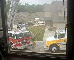
The BCFPD at a working structure fire.
The Boone County Fire Protection District provides fire protection and emergency medical services for a large portion of Boone County, Missouri.[19] The BCFPD is the largest volunteer fire department and third largest fire service organization in the state, protecting 492 square miles (1,270 km2) of residential, commercial, industrial and agricultural property and over 50,000 people.[19] The Boone County Fire District maintains 14 fire stations, a training center, and a headquarters facility.[20]
History
Prior to 1964, there was no organized fire protection in Boone County. This changed after an elderly handicapped woman died in a house fire just west of the city limits of Columbia. A small group of CB radio enthusiasts, known as the Central Missouri Radio Squad, banded together to develop a fire protection system for Boone County.[21]
References
- 1 2 "State & County QuickFacts". United States Census Bureau. Archived from the original on April 17, 2016. Retrieved September 16, 2016.
- ↑ Eaton, David Wolfe (1916). How Missouri Counties, Towns and Streams Were Named. The State Historical Society of Missouri. p. 211.
- ↑ The Story of Little Dixie, Missouri, Missouri Division, Sons of Confederate Veterans, accessed 3 June 2008
- ↑ T. J. Stiles, Jesse James: The Last Rebel of the Civil War, New York: Vintage Books, 2003, pp.10-11
- ↑ "2010 Census Gazetteer Files". United States Census Bureau. August 22, 2012. Archived from the original on October 21, 2013. Retrieved November 13, 2014.
- ↑ "Population and Housing Unit Estimates". Retrieved June 9, 2017.
- ↑ "U.S. Decennial Census". United States Census Bureau. Archived from the original on May 12, 2015. Retrieved November 13, 2014.
- ↑ "Historical Census Browser". University of Virginia Library. Retrieved November 13, 2014.
- ↑ "Population of Counties by Decennial Census: 1900 to 1990". United States Census Bureau. Retrieved November 13, 2014.
- ↑ "Census 2000 PHC-T-4. Ranking Tables for Counties: 1990 and 2000" (PDF). United States Census Bureau. Retrieved November 13, 2014.
- ↑ "American FactFinder". United States Census Bureau. Archived from the original on 2013-09-11. Retrieved 2011-05-14.
- ↑ Registered Voters in Missouri 2008
- ↑ Breeding, Marshall. "Centralia Public Library". Libraries.org. Retrieved May 8, 2017.
- ↑ Breeding, Marshall. "Daniel Boone Regional Library". Libraries.org. Retrieved May 8, 2017.
- 1 2 3 4 5 6 7 8 "Boone County, Missouri - November 8, 2016 - General Election". County Clerk. November 21, 2016. Retrieved April 14, 2017.
- 1 2 3 4 5 6 "County Results, State of Missouri - General Election - November 4, 2014". Retrieved March 23, 2016.
- 1 2 3 4 5 6 7 8 "County Results, State of Missouri - General Election - November 6, 2012". Retrieved March 23, 2016.
- ↑ Leip, David. "Dave Leip's Atlas of U.S. Presidential Elections". uselectionatlas.org. Retrieved 2018-03-24.
- 1 2 "Fun Facts". Boone County Fire. Retrieved 22 May 2015.
- ↑ "Boone County Fire Protection District" (PDF). Bcfdmo.coma. Retrieved 2012-11-16.
- ↑ "History". Boone County Fire Protection District. Archived from the original on 7 November 2010. Retrieved 27 May 2015.
- ↑ "US&R Task Force Locations". FEMA. Archived from the original on July 5, 2012. Retrieved August 28, 2006.
- ↑ "USAR Task Force". Boone County Fire. Retrieved 22 May 2015.
Further reading
- History of Boone County, Missouri: Written and comp. from the most authentic official and private sources; including a history of its townships, towns, and villages. Together with ... biographical sketches and portraits of prominent citizens (1882) online
External links
Places adjacent to Boone County, Missouri |
|---|
|


.svg.png)