Warren County, Missouri
| Warren County, Missouri | |
|---|---|
 Warren County Courthouse in Warrenton | |
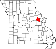 Location in the U.S. state of Missouri | |
 Missouri's location in the U.S. | |
| Founded | January 5, 1833 |
| Named for | Joseph Warren |
| Seat | Warrenton |
| Largest city | Warrenton |
| Area | |
| • Total | 438 sq mi (1,134 km2) |
| • Land | 429 sq mi (1,111 km2) |
| • Water | 9.2 sq mi (24 km2), 2.1% |
| Population (est.) | |
| • (2015) | 33,513 |
| • Density | 76/sq mi (29/km2) |
| Congressional district | 3rd |
| Time zone | Central: UTC−6/−5 |
| Website |
www |
Warren County is a county located in the eastern portion of the U.S. state of Missouri. As of the 2010 census, the population was 32,513.[1] The county is located on the north side of the Missouri River. Its county seat is Warrenton.[2] The county was organized on January 5, 1833, and named for General Joseph Warren, who died in the Battle of Bunker Hill during the American Revolutionary War.[3]
Warren County is part of the St. Louis, MO-IL Metropolitan Statistical Area. The county is traversed by Route 94, called the "Missouri Weinstrasse" because of the many vineyards from Marthasville east into St. Charles County. Warren County is also part of the Missouri Rhineland, with award-winning wineries located on both sides of the Missouri River.
Geography
According to the U.S. Census Bureau, the county has a total area of 438 square miles (1,130 km2), of which 429 square miles (1,110 km2) is land and 9.2 square miles (24 km2) (2.1%) is water.[4]
Adjacent counties
- Lincoln County (north)
- St. Charles County (east)
- Franklin County (south)
- Gasconade County (southwest)
- Montgomery County (west)
Major highways
Demographics
| Historical population | |||
|---|---|---|---|
| Census | Pop. | %± | |
| 1840 | 4,253 | — | |
| 1850 | 5,860 | 37.8% | |
| 1860 | 8,839 | 50.8% | |
| 1870 | 9,673 | 9.4% | |
| 1880 | 10,806 | 11.7% | |
| 1890 | 9,913 | −8.3% | |
| 1900 | 9,919 | 0.1% | |
| 1910 | 9,123 | −8.0% | |
| 1920 | 8,490 | −6.9% | |
| 1930 | 8,082 | −4.8% | |
| 1940 | 7,734 | −4.3% | |
| 1950 | 7,666 | −0.9% | |
| 1960 | 8,750 | 14.1% | |
| 1970 | 9,699 | 10.8% | |
| 1980 | 14,900 | 53.6% | |
| 1990 | 19,534 | 31.1% | |
| 2000 | 24,525 | 25.6% | |
| 2010 | 32,513 | 32.6% | |
| Est. 2016 | 33,802 | [5] | 4.0% |
| U.S. Decennial Census[6] 1790-1960[7] 1900-1990[8] 1990-2000[9] 2010-2015[1] | |||
As of the census[10] of 2000, there were 24,525 people, 9,185 households, and 6,888 families residing in the county. The population density was 57 people per square mile (22/km²). There were 11,046 housing units at an average density of 26 per square mile (10/km²). The racial makeup of the county was 95.89% White, 1.94% Black or African American, 0.45% Native American, 0.24% Asian, 0.02% Pacific Islander, 0.44% from other races, and 1.02% from two or more races. Approximately 1.28% of the population were Hispanic or Latino of any race. Among the major ancestries reported in Warren County were 41.4% German, 13.8% American, 10.2% Irish and 7.0% English ancestry.
There were 9,185 households out of which 34.70% had children under the age of 18 living with them, 62.20% were married couples living together, 8.90% had a female householder with no husband present, and 25.00% were non-families. 20.80% of all households were made up of individuals and 8.80% had someone living alone who was 65 years of age or older. The average household size was 2.64 and the average family size was 3.05.
In the county, the population was spread out with 26.90% under the age of 18, 7.60% from 18 to 24, 28.80% from 25 to 44, 23.70% from 45 to 64, and 13.00% who were 65 years of age or older. The median age was 37 years. For every 100 females there were 98.60 males. For every 100 females age 18 and over, there were 96.10 males.
The median income for a household in the county was $41,016, and the median income for a family was $46,863. Males had a median income of $36,315 versus $23,443 for females. The per capita income for the county was $19,690. About 6.40% of families and 8.60% of the population were below the poverty line, including 10.50% of those under age 18 and 10.40% of those age 65 or over.
Politics
Local
All of the elected positions in the county are held by Republicans.
| Warren County, Missouri | ||||
|---|---|---|---|---|
| Elected countywide officials | ||||
| Assessor | Wendy Nordwald | Republican | ||
| Circuit Clerk | Brenda Eggering | Republican | ||
| County Clerk | Barbara Daly | Republican | ||
| Collector | Linda K. Stude | Republican | ||
| Commissioner (Presiding) |
Arden Engelage | Republican | ||
| Commissioner (District 1) |
Daniel Hampson | Republican | ||
| Commissioner (District 2) |
Hubert Kluesner | Republican | ||
| Coroner | Roger R. Mauzy, Sr. | Republican | ||
| Prosecuting Attorney | Michael S. Wright | Republican | ||
| Public Administrator | Jeffrey Hoelscher | Republican | ||
| Recorder | Deborah Engemann | Republican | ||
| Sheriff | Kevin Harrison | Republican | ||
| Surveyor | Robert L. Lewis | Republican | ||
| Treasurer | Gene Cornell | Republican | ||
State
| Year | Republican | Democratic | Third Parties |
|---|---|---|---|
| 2016 | 57.58% 9,056 | 38.50% 6,055 | 3.93% 618 |
| 2012 | 50.34% 7,338 | 46.78% 6,819 | 2.88% 419 |
| 2008 | 49.26% 7,617 | 49.07% 7,587 | 1.68% 259 |
| 2004 | 56.08% 7,488 | 42.61% 5,689 | 1.31% 175 |
| 2000 | 56.76% 6,060 | 40.45% 4,318 | 2.79% 298 |
| 1996 | 49.93% 4,298 | 47.67% 4,103 | 2.40% 207 |
Warren County is divided into two legislative districts in the Missouri House of Representatives, both of which are held by Republicans.
- District 42 — Bart Korman (R-High Hill). Consists of most of the entire county, including the communities of Marthasville, Pendeleton, Truesdale, and Warrenton.
| Party | Candidate | Votes | % | ± | |
|---|---|---|---|---|---|
| Republican | Bart Korman | 9,880 | 100.00% | +25.74 | |
| Party | Candidate | Votes | % | ± | |
|---|---|---|---|---|---|
| Republican | Bart Korman | 4,210 | 74.26% | -25.74 | |
| Democratic | Rod Sturgeon | 1,459 | 25.74% | +25.74 | |
| Party | Candidate | Votes | % | ± | |
|---|---|---|---|---|---|
| Republican | Bart Korman | 8,812 | 100.00% | ||
- District 63 — Bryan Spencer (R-Wentzville). Consists of the communities of Foristell, Innsbrook, and Wright City.
| Party | Candidate | Votes | % | ± | |
|---|---|---|---|---|---|
| Republican | Bryan Spencer | 3,039 | 70.67% | +0.88 | |
| Democratic | Liz Gattra | 1,261 | 29.33% | -0.88 | |
| Party | Candidate | Votes | % | ± | |
|---|---|---|---|---|---|
| Republican | Bryan Spencer | 1,423 | 69.79% | +11.67 | |
| Democratic | Bryan Pinette | 616 | 30.21% | -11.67 | |
| Party | Candidate | Votes | % | ± | |
|---|---|---|---|---|---|
| Republican | Bryan Spencer | 2,233 | 58.12% | ||
| Democratic | Bill Stinson | 1,609 | 41.88% | ||
Warren County is a part of Missouri's 10th District in the Missouri Senate and is currently represented by Jeanie Riddle (R-Fulton). The 10th Senatorial District consists of all of Audrain, Callaway, Lincoln, Monroe, Montgomery, and Warren counties.
| Party | Candidate | Votes | % | ± | |
|---|---|---|---|---|---|
| Republican | Jeanie Riddle | 5,475 | 70.78% | ||
| Democratic | Ed Schieffer | 2,260 | 29.22% | ||
Federal
| Party | Candidate | Votes | % | ± | |
|---|---|---|---|---|---|
| Republican | Roy Blunt | 8,918 | 56.69% | +8.24 | |
| Democratic | Jason Kander | 5,928 | 37.68% | -7.68 | |
| Libertarian | Jonathan Dine | 445 | 2.83% | -3.36 | |
| Green | Johnathan McFarland | 183 | 1.16% | +1.16 | |
| Constitution | Fred Ryman | 257 | 1.63% | +1.63 | |
| Party | Candidate | Votes | % | ± | |
|---|---|---|---|---|---|
| Republican | Todd Akin | 7,040 | 48.45% | ||
| Democratic | Claire McCaskill | 6,591 | 45.36% | ||
| Libertarian | Jonathan Dine | 899 | 6.19% | ||
Warren County is included in Missouri's 3rd Congressional District and is represented by Blaine Luetkemeyer (R-St. Elizabeth) in the U.S. House of Representatives.
| Party | Candidate | Votes | % | ± | |
|---|---|---|---|---|---|
| Republican | Blaine Luetkemeyer | 10,884 | 70.55% | -1.61 | |
| Democratic | Kevin Miller | 3,847 | 24.94% | +0.96 | |
| Libertarian | Dan Hogan | 480 | 3.11% | -0.75 | |
| Constitution | Doanita Simmons | 216 | 1.40% | +1.40 | |
| Party | Candidate | Votes | % | ± | |
|---|---|---|---|---|---|
| Republican | Blaine Luetkemeyer | 5,587 | 72.16% | +6.07 | |
| Democratic | Courtney Denton | 1,857 | 23.98% | -6.53 | |
| Libertarian | Steven Hedrick | 299 | 3.86% | +0.46 | |
| Party | Candidate | Votes | % | ± | |
|---|---|---|---|---|---|
| Republican | Blaine Luetkemeyer | 9,429 | 66.09% | ||
| Democratic | Eric Mayer | 4,352 | 30.51% | ||
| Libertarian | Steven Wilson | 485 | 3.40% | ||
Political culture
| Year | Republican | Democratic | Third parties |
|---|---|---|---|
| 2016 | 70.4% 11,111 | 24.8% 3,915 | 4.8% 758 |
| 2012 | 62.4% 9,150 | 35.6% 5,219 | 2.1% 307 |
| 2008 | 55.7% 8,675 | 43.1% 6,705 | 1.3% 196 |
| 2004 | 58.7% 7,883 | 40.7% 5,461 | 0.7% 88 |
| 2000 | 55.7% 5,979 | 42.1% 4,524 | 2.2% 237 |
| 1996 | 43.8% 3,768 | 40.0% 3,443 | 16.2% 1,396 |
| 1992 | 34.1% 2,953 | 37.1% 3,213 | 28.8% 2,493 |
| 1988 | 60.1% 4,452 | 39.6% 2,935 | 0.3% 24 |
| 1984 | 72.4% 5,150 | 27.6% 1,964 | |
| 1980 | 64.8% 4,366 | 31.6% 2,132 | 3.6% 245 |
| 1976 | 59.2% 3,214 | 39.9% 2,164 | 1.0% 52 |
| 1972 | 74.2% 3,530 | 25.8% 1,225 | |
| 1968 | 62.6% 2,669 | 24.2% 1,033 | 13.2% 565 |
| 1964 | 55.0% 2,323 | 45.0% 1,903 | |
| 1960 | 67.7% 2,946 | 32.3% 1,407 | |
| 1956 | 70.2% 2,852 | 29.8% 1,211 | |
| 1952 | 72.7% 2,977 | 27.1% 1,112 | 0.2% 8 |
| 1948 | 68.6% 2,380 | 30.9% 1,071 | 0.5% 17 |
| 1944 | 78.4% 3,017 | 21.2% 815 | 0.4% 15 |
| 1940 | 78.3% 3,403 | 21.0% 914 | 0.6% 27 |
| 1936 | 67.0% 2,639 | 32.4% 1,277 | 0.6% 25 |
| 1932 | 56.1% 1,974 | 43.0% 1,513 | 0.8% 29 |
| 1928 | 72.1% 2,610 | 27.6% 999 | 0.3% 11 |
| 1924 | 76.0% 2,667 | 18.4% 644 | 5.6% 197 |
| 1920 | 85.0% 3,512 | 13.2% 545 | 1.8% 76 |
| 1916 | 76.7% 1,752 | 21.3% 487 | 2.0% 46 |
| 1912 | 52.2% 1,067 | 21.1% 431 | 26.7% 546 |
| 1908 | 76.1% 1,714 | 21.5% 484 | 2.4% 53 |
| 1904 | 75.3% 1,537 | 21.3% 435 | 3.4% 69 |
| 1900 | 71.5% 1,599 | 25.9% 579 | 2.7% 60 |
| 1896 | 70.7% 1,680 | 29.1% 691 | 0.3% 7 |
| 1892 | 64.9% 1,360 | 32.7% 685 | 2.5% 52 |
| 1888 | 69.8% 1,498 | 27.5% 589 | 2.8% 59 |
At the presidential level, like many exurban counties, Warren County tends to lean Republican. Bill Clinton in 1992 is the solitary Democratic presidential nominee to carry Warren County since Stephen Douglas in 1860,[12] and Clinton only won with 37.1 percent of the vote.[13]
Like most rural and exurban areas throughout Northeast Missouri, voters in Warren County generally adhere to socially and culturally conservative principles which tend to influence their Republican leanings. In 2004, Missourians voted on a constitutional amendment to define marriage as the union between a man and a woman—it overwhelmingly passed Warren County with 75.87 percent of the vote. The initiative passed the state with 71 percent of support from voters as Missouri became the first state to ban same-sex marriage. In 2006, Missourians voted on a constitutional amendment to fund and legalize embryonic stem cell research in the state—it failed in Warren County with 53.23 percent voting against the measure. The initiative narrowly passed the state with 51 percent of support from voters as Missouri became one of the first states in the nation to approve embryonic stem cell research. Despite Warren County's longstanding tradition of supporting socially conservative platforms, voters in the county have a penchant for advancing populist causes like increasing the minimum wage. In 2006, Missourians voted on a proposition (Proposition B) to increase the minimum wage in the state to $6.50 an hour—it passed Warren County with 77.48 percent of the vote. The proposition strongly passed every single county in Missouri with 78.99 percent voting in favor. (During the same election, voters in five other states also strongly approved increases in the minimum wage.)
Missouri presidential preference primary (2008)
| Warren County, Missouri | |
|---|---|
| 2008 Republican primary in Missouri | |
| John McCain | 1,192 (33.87%) |
| Mike Huckabee | 988 (28.08%) |
| Mitt Romney | 1,139 (32.37%) |
| Ron Paul | 130 (3.69%) |
| Warren County, Missouri | |
|---|---|
| 2008 Democratic primary in Missouri | |
| Hillary Clinton | 1,971 (56.46%) |
| Barack Obama | 1,399 (40.07%) |
| John Edwards (withdrawn) | 92 (2.64%) |
| Uncommitted | {{{uncommitted}}} |
Former U.S. Senator Hillary Rodham Clinton (D-New York) received more votes, a total of 1,971, than any candidate from either party in Warren County during the 2008 presidential primary.
Education
Public schools
- Warren County R-III School District - Warrenton
- Daniel Boone Elementary School (PK-05)
- Warrior Ridge Elementary School (K-05)
- Rebecca Boone Elementary School (K-05)
- Black Hawk Middle School (06-08)
- Warrenton High School (09-12)
- Wright City R-II School District - Wright City
- Wright City East Elementary School (K-01) - Foristell
- Wright City Elementary School (02-05)
- Wright City Middle School (06-08)
- Wright City High School (09-12)
Private schools
- Holy Rosary School – Warrenton (K-08) – Roman Catholic
- St. Vincent De Paul School – Marthasville (K-08) – Roman Catholic
- St. Ignatius Loyola School – Marthasville (PK-08) – Roman Catholic
Public libraries
- Warrenton Branch Library[14]
Communities
Cities
- Foristell
- Marthasville
- Truesdale
- Warrenton (county seat)
- Wright City
Villages
Unincorporated communities
Media
See also
References
- 1 2 "State & County QuickFacts". United States Census Bureau. Retrieved September 14, 2013.
- ↑ "Find a County". National Association of Counties. Retrieved 2011-06-07.
- ↑ Eaton, David Wolfe (1918). How Missouri Counties, Towns and Streams Were Named. The State Historical Society of Missouri. p. 369.
- ↑ "2010 Census Gazetteer Files". United States Census Bureau. August 22, 2012. Archived from the original on October 21, 2013. Retrieved November 22, 2014.
- ↑ "Population and Housing Unit Estimates". Retrieved June 9, 2017.
- ↑ "U.S. Decennial Census". United States Census Bureau. Retrieved November 22, 2014.
- ↑ "Historical Census Browser". University of Virginia Library. Retrieved November 22, 2014.
- ↑ "Population of Counties by Decennial Census: 1900 to 1990". United States Census Bureau. Retrieved November 22, 2014.
- ↑ "Census 2000 PHC-T-4. Ranking Tables for Counties: 1990 and 2000" (PDF). United States Census Bureau. Retrieved November 22, 2014.
- ↑ "American FactFinder". United States Census Bureau. Retrieved 2008-01-31.
- ↑ Leip, David. "Dave Leip's Atlas of U.S. Presidential Elections". uselectionatlas.org. Retrieved 2018-03-27.
- ↑ The Political Graveyard; Warren County, Missouri
- ↑ Dave Leip’s Atlas of U.S. Presidential Elections; 1992 Presidential General Election Data Graphs – Missouri
- ↑ Breeding, Marshall. "Warrenton Branch Library". Libraries.org. Retrieved May 8, 2017.
External links
- Official site
- Digitized 1930 Plat Book of Warren County from University of Missouri Division of Special Collections, Archives, and Rare Books
Places adjacent to Warren County, Missouri | ||||||||||
|---|---|---|---|---|---|---|---|---|---|---|
| ||||||||||
| Topics | 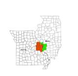 | |
|---|---|---|
| Central city | ||
| Largest cities (over 50,000 in 2010) | ||
| Medium-sized cities (over 20,000 in 2010) | ||
| Largest towns and villages (over 10,000 in 2010) |
| |
| Missouri Counties | ||
| Illinois Counties | ||
| Subregions | ||
Municipalities and communities of Warren County, Missouri, United States | ||
|---|---|---|
| Cities | | |
| Villages | ||
| Townships |
| |
| Unincorporated communities | ||
| Ghost towns | ||
| Footnotes | ‡This populated place also has portions in an adjacent county or counties | |
