Peerless Park, Missouri
| Peerless Park, Missouri | |
|---|---|
| Unincorporated community | |
 Peerless Park, Missouri | |
| Coordinates: 38°32′36″N 90°29′42″W / 38.54333°N 90.49500°WCoordinates: 38°32′36″N 90°29′42″W / 38.54333°N 90.49500°W | |
| Country | United States |
| State | Missouri |
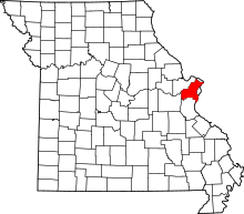
| County | St. Louis |
| Elevation | 446 ft (136 m) |
| Time zone | UTC-6 (Central (CST)) |
| • Summer (DST) | UTC-5 (CDT) |
| ZIP code | 63088 |
| Area code(s) | 636 |
| FIPS code | 29-56792[1] |
| GNIS feature ID | 756514[1] |
Peerless Park, Missouri is a former, disincorporated town located at the junction of Interstate 44 and Route 141 in St. Louis County. It was incorporated in 1935,[2] and by the 1980s, the majority of the town was businesses and its population did not exceed 50. At the request of its citizens, the town was disincorporated in May 1, 1998.[1]
The former Peerless Park has since been annexed by the City of Valley Park, Missouri.[3]
Demographics
| Historical population | |||
|---|---|---|---|
| Census | Pop. | %± | |
| 1940 | 47 | — | |
| 1950 | 119 | 153.2% | |
| 1960 | 99 | −16.8% | |
| 1970 | 51 | −48.5% | |
| 1980 | 79 | 54.9% | |
| 1990 | 33 | −58.2% | |
| U.S. Decennial Census[2] | |||
References
This article is issued from
Wikipedia.
The text is licensed under Creative Commons - Attribution - Sharealike.
Additional terms may apply for the media files.