Villeneuve-d'Olmes
| Villeneuve-d'Olmes | ||
|---|---|---|
| Commune | ||
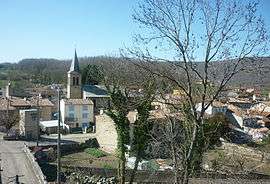 A general view of Villeneuve-d'Olmes | ||
| ||
 Villeneuve-d'Olmes Location within Occitanie region  Villeneuve-d'Olmes | ||
| Coordinates: 42°54′30″N 1°49′16″E / 42.9083°N 1.8211°ECoordinates: 42°54′30″N 1°49′16″E / 42.9083°N 1.8211°E | ||
| Country | France | |
| Region | Occitanie | |
| Department | Ariège | |
| Arrondissement | Pamiers | |
| Canton | Pays d'Olmes | |
| Intercommunality | Pays d'Olmes | |
| Government | ||
| • Mayor (2008–2014) | Gérald Sgobbo | |
| Area1 | 5.92 km2 (2.29 sq mi) | |
| Population (2008)2 | 1,164 | |
| • Density | 200/km2 (510/sq mi) | |
| Time zone | UTC+1 (CET) | |
| • Summer (DST) | UTC+2 (CEST) | |
| INSEE/Postal code | 09336 /09300 | |
| Elevation |
544–880 m (1,785–2,887 ft) (avg. 600 m or 2,000 ft) | |
|
1 French Land Register data, which excludes lakes, ponds, glaciers > 1 km2 (0.386 sq mi or 247 acres) and river estuaries. 2 Population without double counting: residents of multiple communes (e.g., students and military personnel) only counted once. | ||
.svg.png)
Villeneuve-d'Olmes is a commune in the Ariège department in southwestern France.
Population
Inhabitants of Villeneuve-d'Olmes are called Villeneuvois.
| Historical population | ||
|---|---|---|
| Year | Pop. | ±% |
| 1962 | 903 | — |
| 1968 | 911 | +0.9% |
| 1975 | 1,339 | +47.0% |
| 1982 | 1,816 | +35.6% |
| 1990 | 1,574 | −13.3% |
| 1999 | 1,292 | −17.9% |
| 2008 | 1,164 | −9.9% |
See also
References
| Wikimedia Commons has media related to Villeneuve-d'Olmes. |
This article is issued from
Wikipedia.
The text is licensed under Creative Commons - Attribution - Sharealike.
Additional terms may apply for the media files.