Orus
- For the Greek grammarian Orus (or Oros), see Oros of Alexandria. For the asteroid, see 21900 Orus
| Orus | |
|---|---|
| Commune | |
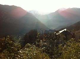 A view of the Pyrenees from Orus. | |
 Orus Location within Occitanie region  Orus | |
| Coordinates: 42°46′59″N 1°30′29″E / 42.7831°N 1.5081°ECoordinates: 42°46′59″N 1°30′29″E / 42.7831°N 1.5081°E | |
| Country | France |
| Region | Occitanie |
| Department | Ariège |
| Arrondissement | Foix |
| Canton | Sabarthès |
| Intercommunality | Auzat-Vicdessos |
| Government | |
| • Mayor (2008–2014) | Éric Delpy |
| Area1 | 9.12 km2 (3.52 sq mi) |
| Population (2008)2 | 22 |
| • Density | 2.4/km2 (6.2/sq mi) |
| Time zone | UTC+1 (CET) |
| • Summer (DST) | UTC+2 (CEST) |
| INSEE/Postal code | 09222 /09220 |
| Elevation |
819–1,980 m (2,687–6,496 ft) (avg. 981 m or 3,219 ft) |
|
1 French Land Register data, which excludes lakes, ponds, glaciers > 1 km2 (0.386 sq mi or 247 acres) and river estuaries. 2 Population without double counting: residents of multiple communes (e.g., students and military personnel) only counted once. | |
Orus is a commune in the Ariège department in southwestern France.
Population
Inhabitants of Orus are called Orusiens.
| Historical population | ||
|---|---|---|
| Year | Pop. | ±% |
| 1962 | 8 | — |
| 1968 | 15 | +87.5% |
| 1975 | 11 | −26.7% |
| 1982 | 13 | +18.2% |
| 1990 | 20 | +53.8% |
| 1999 | 18 | −10.0% |
| 2008 | 22 | +22.2% |
See also
References
| Wikimedia Commons has media related to Orus. |
This article is issued from
Wikipedia.
The text is licensed under Creative Commons - Attribution - Sharealike.
Additional terms may apply for the media files.