Aigues-Juntes
| Aigues-Juntes | |
|---|---|
| Commune | |
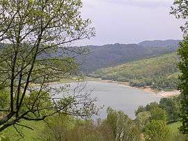 Mondély Lake | |
 Aigues-Juntes Location within Occitanie region  Aigues-Juntes | |
| Coordinates: 43°03′23″N 1°28′18″E / 43.0564°N 1.4717°ECoordinates: 43°03′23″N 1°28′18″E / 43.0564°N 1.4717°E | |
| Country | France |
| Region | Occitanie |
| Department | Ariège |
| Arrondissement | Saint-Girons |
| Canton | Couserans Est |
| Intercommunality | Seronnais 117 |
| Government | |
| • Mayor (2014-2020) | Gilles Soula |
| Area1 | 7.77 km2 (3.00 sq mi) |
| Population (2014)2 | 58 |
| • Density | 7.5/km2 (19/sq mi) |
| Time zone | UTC+1 (CET) |
| • Summer (DST) | UTC+2 (CEST) |
| INSEE/Postal code | 09001 /09240 |
| Elevation |
340–616 m (1,115–2,021 ft) (avg. 580 m or 1,900 ft) |
|
1 French Land Register data, which excludes lakes, ponds, glaciers > 1 km2 (0.386 sq mi or 247 acres) and river estuaries. 2 Population without double counting: residents of multiple communes (e.g., students and military personnel) only counted once. | |
Aigues-Juntes is a commune in the Ariège department in southwestern France.
Geography
The Lèze, tributary of the Ariège, forms part of the commune's southwestern and northwestern borders.
Population
Inhabitants of Aigues-Juntes are called Aigues-Juntais.
| Historical population | ||
|---|---|---|
| Year | Pop. | ±% |
| 1793 | 280 | — |
| 1800 | 256 | −8.6% |
| 1806 | 427 | +66.8% |
| 1821 | 328 | −23.2% |
| 1831 | 312 | −4.9% |
| 1836 | 326 | +4.5% |
| 1841 | 329 | +0.9% |
| 1846 | 344 | +4.6% |
| 1851 | 360 | +4.7% |
| 1856 | 333 | −7.5% |
| 1861 | 335 | +0.6% |
| 1866 | 298 | −11.0% |
| 1872 | 307 | +3.0% |
| 1876 | 287 | −6.5% |
| 1881 | 302 | +5.2% |
| 1886 | 273 | −9.6% |
| 1891 | 249 | −8.8% |
| 1896 | 234 | −6.0% |
| 1901 | 221 | −5.6% |
| 1906 | 206 | −6.8% |
| 1911 | 204 | −1.0% |
| 1921 | 160 | −21.6% |
| 1926 | 141 | −11.9% |
| 1931 | 132 | −6.4% |
| 1936 | 155 | +17.4% |
| 1946 | 151 | −2.6% |
| 1954 | 112 | −25.8% |
| 1962 | 95 | −15.2% |
| 1968 | 81 | −14.7% |
| 1975 | 63 | −22.2% |
| 1982 | 59 | −6.3% |
| 1990 | 42 | −28.8% |
| 1999 | 49 | +16.7% |
| 2008 | 41 | −16.3% |
See also
References
| Wikimedia Commons has media related to Aigues-Juntes. |
This article is issued from
Wikipedia.
The text is licensed under Creative Commons - Attribution - Sharealike.
Additional terms may apply for the media files.