Vals, Ariège
| Vals | ||
|---|---|---|
| Commune | ||
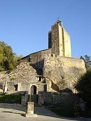 The church in Vals | ||
| ||
 Vals Location within Occitanie region  Vals | ||
| Coordinates: 43°05′49″N 1°45′41″E / 43.0969°N 1.7614°ECoordinates: 43°05′49″N 1°45′41″E / 43.0969°N 1.7614°E | ||
| Country | France | |
| Region | Occitanie | |
| Department | Ariège | |
| Arrondissement | Pamiers | |
| Canton | Mirepoix | |
| Intercommunality | Moyenne vallée de l'Hers | |
| Government | ||
| • Mayor (2008–2014) | Jean Pons | |
| Area1 | 4.13 km2 (1.59 sq mi) | |
| Population (2008)2 | 86 | |
| • Density | 21/km2 (54/sq mi) | |
| Time zone | UTC+1 (CET) | |
| • Summer (DST) | UTC+2 (CEST) | |
| INSEE/Postal code | 09323 /09500 | |
| Elevation |
255–390 m (837–1,280 ft) (avg. 270 m or 890 ft) | |
|
1 French Land Register data, which excludes lakes, ponds, glaciers > 1 km2 (0.386 sq mi or 247 acres) and river estuaries. 2 Population without double counting: residents of multiple communes (e.g., students and military personnel) only counted once. | ||
.svg.png)
Vals is a commune in the Ariège department in southwestern France.
It is known for the church "Eglise Rupestre de Vals" which is literally built right into the giant rocks that make up its foundation. Picturesque in itself, it has a view of the valley spread out before it.
Population
Inhabitants of Vals are called Valséens.
| Historical population | ||
|---|---|---|
| Year | Pop. | ±% |
| 1962 | 28 | — |
| 1968 | 54 | +92.9% |
| 1975 | 46 | −14.8% |
| 1982 | 45 | −2.2% |
| 1990 | 59 | +31.1% |
| 1999 | 67 | +13.6% |
| 2008 | 86 | +28.4% |
See also
References
| Wikimedia Commons has media related to Vals, Ariège. |
This article is issued from
Wikipedia.
The text is licensed under Creative Commons - Attribution - Sharealike.
Additional terms may apply for the media files.