Orgeix
| Orgeix | |
|---|---|
| Commune | |
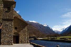 The church and surroundings in Orgeix | |
 Orgeix Location within Occitanie region  Orgeix | |
| Coordinates: 42°42′35″N 1°52′02″E / 42.7097°N 1.8672°ECoordinates: 42°42′35″N 1°52′02″E / 42.7097°N 1.8672°E | |
| Country | France |
| Region | Occitanie |
| Department | Ariège |
| Arrondissement | Foix |
| Canton | Haute-Ariège |
| Intercommunality | Vallées d'Ax |
| Government | |
| • Mayor (2008–2014) | Gérard Authier |
| Area1 | 18.39 km2 (7.10 sq mi) |
| Population (2008)2 | 101 |
| • Density | 5.5/km2 (14/sq mi) |
| Time zone | UTC+1 (CET) |
| • Summer (DST) | UTC+2 (CEST) |
| INSEE/Postal code | 09218 /09110 |
| Elevation |
800–2,481 m (2,625–8,140 ft) (avg. 820 m or 2,690 ft) |
|
1 French Land Register data, which excludes lakes, ponds, glaciers > 1 km2 (0.386 sq mi or 247 acres) and river estuaries. 2 Population without double counting: residents of multiple communes (e.g., students and military personnel) only counted once. | |
Orgeix is a commune in the Ariège department in southwestern France.
It is located just two kilometers from the hot springs and ski resort Ax-les-Thermes and European Route E09
Population
Inhabitants are called Orgeixois.
| Historical population | ||
|---|---|---|
| Year | Pop. | ±% |
| 1962 | 46 | — |
| 1968 | 61 | +32.6% |
| 1975 | 61 | +0.0% |
| 1982 | 53 | −13.1% |
| 1990 | 65 | +22.6% |
| 1999 | 71 | +9.2% |
| 2008 | 101 | +42.3% |
See also
References
| Wikimedia Commons has media related to Orgeix. |
This article is issued from
Wikipedia.
The text is licensed under Creative Commons - Attribution - Sharealike.
Additional terms may apply for the media files.