Saint-Quentin-la-Tour
| Saint-Quentin-la-Tour | ||
|---|---|---|
| Commune | ||
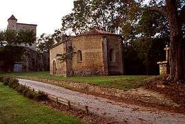 The church in Saint-Quentin-la-Tour | ||
| ||
 Saint-Quentin-la-Tour Location within Occitanie region  Saint-Quentin-la-Tour | ||
| Coordinates: 43°02′03″N 1°53′59″E / 43.0342°N 1.8997°ECoordinates: 43°02′03″N 1°53′59″E / 43.0342°N 1.8997°E | ||
| Country | France | |
| Region | Occitanie | |
| Department | Ariège | |
| Arrondissement | Pamiers | |
| Canton | Mirepoix | |
| Intercommunality | Pays de Mirepoix | |
| Government | ||
| • Mayor (2008–2014) | Claude Lazerges | |
| Area1 | 9.02 km2 (3.48 sq mi) | |
| Population (2008)2 | 326 | |
| • Density | 36/km2 (94/sq mi) | |
| Time zone | UTC+1 (CET) | |
| • Summer (DST) | UTC+2 (CEST) | |
| INSEE/Postal code | 09274 /09500 | |
| Elevation |
334–463 m (1,096–1,519 ft) (avg. 359 m or 1,178 ft) | |
|
1 French Land Register data, which excludes lakes, ponds, glaciers > 1 km2 (0.386 sq mi or 247 acres) and river estuaries. 2 Population without double counting: residents of multiple communes (e.g., students and military personnel) only counted once. | ||
.svg.png)
Saint-Quentin-la-Tour is a commune in the Ariège department in southwestern France.
Population
Inhabitants of Saint-Quentin-la-Tour are called Saint-Quentinois.
| Historical population | ||
|---|---|---|
| Year | Pop. | ±% |
| 1962 | 244 | — |
| 1968 | 255 | +4.5% |
| 1975 | 250 | −2.0% |
| 1982 | 278 | +11.2% |
| 1990 | 306 | +10.1% |
| 1999 | 297 | −2.9% |
| 2008 | 326 | +9.8% |
See also
References
| Wikimedia Commons has media related to Saint-Quentin-la-Tour. |
This article is issued from
Wikipedia.
The text is licensed under Creative Commons - Attribution - Sharealike.
Additional terms may apply for the media files.