Quérigut
| Quérigut | |
|---|---|
| Commune | |
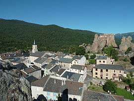 A general view of Quérigut | |
 Quérigut Location within Occitanie region  Quérigut | |
| Coordinates: 42°42′00″N 2°05′57″E / 42.7°N 2.0992°ECoordinates: 42°42′00″N 2°05′57″E / 42.7°N 2.0992°E | |
| Country | France |
| Region | Occitanie |
| Department | Ariège |
| Arrondissement | Foix |
| Canton | Haute-Ariège |
| Intercommunality | Donezan |
| Government | |
| • Mayor (2014–2020) | Roger Vidal |
| Area1 | 36.4 km2 (14.1 sq mi) |
| Population (2008)2 | 139 |
| • Density | 3.8/km2 (9.9/sq mi) |
| Time zone | UTC+1 (CET) |
| • Summer (DST) | UTC+2 (CEST) |
| INSEE/Postal code | 09239 /09460 |
| Elevation |
1,022–2,359 m (3,353–7,740 ft) (avg. 1,250 m or 4,100 ft) |
|
1 French Land Register data, which excludes lakes, ponds, glaciers > 1 km2 (0.386 sq mi or 247 acres) and river estuaries. 2 Population without double counting: residents of multiple communes (e.g., students and military personnel) only counted once. | |
Quérigut is a commune in the Ariège department in southwestern France.
Population
Inhabitants are called Quérigutois.
| Historical population | ||
|---|---|---|
| Year | Pop. | ±% |
| 1962 | 197 | — |
| 1968 | 234 | +18.8% |
| 1975 | 171 | −26.9% |
| 1982 | 153 | −10.5% |
| 1990 | 142 | −7.2% |
| 1999 | 116 | −18.3% |
| 2008 | 139 | +19.8% |
See also
References
| Wikimedia Commons has media related to Quérigut. |
This article is issued from
Wikipedia.
The text is licensed under Creative Commons - Attribution - Sharealike.
Additional terms may apply for the media files.