Luzenac
| Luzenac | |
|---|---|
| Commune | |
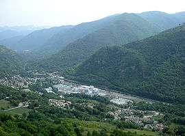 A general view of Luzenac | |
 Luzenac Location within Occitanie region  Luzenac | |
| Coordinates: 42°45′53″N 1°45′52″E / 42.7647°N 1.7644°ECoordinates: 42°45′53″N 1°45′52″E / 42.7647°N 1.7644°E | |
| Country | France |
| Region | Occitanie |
| Department | Ariège |
| Arrondissement | Foix |
| Canton | Haute-Ariège |
| Intercommunality | Vallées d'Ax |
| Government | |
| • Mayor (2008–2014) | Christian Loubet |
| Area1 | 26.43 km2 (10.20 sq mi) |
| Population (2008)2 | 607 |
| • Density | 23/km2 (59/sq mi) |
| Time zone | UTC+1 (CET) |
| • Summer (DST) | UTC+2 (CEST) |
| INSEE/Postal code | 09176 /09250 |
| Elevation |
594–2,247 m (1,949–7,372 ft) (avg. 608 m or 1,995 ft) |
|
1 French Land Register data, which excludes lakes, ponds, glaciers > 1 km2 (0.386 sq mi or 247 acres) and river estuaries. 2 Population without double counting: residents of multiple communes (e.g., students and military personnel) only counted once. | |
Luzenac is a commune in the Ariège department in southwestern France.
Population
| Historical population | ||
|---|---|---|
| Year | Pop. | ±% |
| 1806 | 332 | — |
| 1851 | 504 | +51.8% |
| 1856 | 461 | −8.5% |
| 1901 | 420 | −8.9% |
| 1921 | 507 | +20.7% |
| 1946 | 464 | −8.5% |
| 1954 | 785 | +69.2% |
| 1962 | 898 | +14.4% |
| 1968 | 956 | +6.5% |
| 1975 | 848 | −11.3% |
| 1982 | 816 | −3.8% |
| 1990 | 690 | −15.4% |
| 1999 | 632 | −8.4% |
| 2008 | 607 | −4.0% |
Sports
- Luzenac is also home to the football club Luzenac AP.
See also
References
| Wikimedia Commons has media related to Luzenac. |
This article is issued from
Wikipedia.
The text is licensed under Creative Commons - Attribution - Sharealike.
Additional terms may apply for the media files.