Surba
| Surba | |
|---|---|
| Commune | |
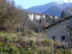 A general view of Surba | |
 Surba Location within Occitanie region  Surba | |
| Coordinates: 42°51′35″N 1°34′33″E / 42.8597°N 1.5758°ECoordinates: 42°51′35″N 1°34′33″E / 42.8597°N 1.5758°E | |
| Country | France |
| Region | Occitanie |
| Department | Ariège |
| Arrondissement | Foix |
| Canton | Sabarthès |
| Intercommunality | Pays de Tarascon |
| Government | |
| • Mayor (2008–2014) | Firmin Hachaguer |
| Area1 | 2.22 km2 (0.86 sq mi) |
| Population (2008)2 | 347 |
| • Density | 160/km2 (400/sq mi) |
| Time zone | UTC+1 (CET) |
| • Summer (DST) | UTC+2 (CEST) |
| INSEE/Postal code | 09303 /09400 |
| Elevation |
469–1,064 m (1,539–3,491 ft) (avg. 558 m or 1,831 ft) |
|
1 French Land Register data, which excludes lakes, ponds, glaciers > 1 km2 (0.386 sq mi or 247 acres) and river estuaries. 2 Population without double counting: residents of multiple communes (e.g., students and military personnel) only counted once. | |
Surba is a commune in the Ariège department in southwestern France.
Population
Inhabitants of Surba are called Surbatois.
| Historical population | ||
|---|---|---|
| Year | Pop. | ±% |
| 1962 | 166 | — |
| 1968 | 179 | +7.8% |
| 1975 | 234 | +30.7% |
| 1982 | 320 | +36.8% |
| 1990 | 381 | +19.1% |
| 1999 | 345 | −9.4% |
| 2008 | 347 | +0.6% |
See also
References
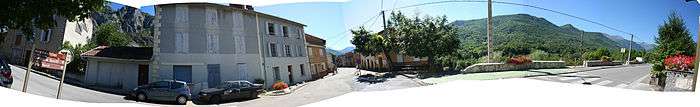
Center of the village
| Wikimedia Commons has media related to Surba. |
This article is issued from
Wikipedia.
The text is licensed under Creative Commons - Attribution - Sharealike.
Additional terms may apply for the media files.