Besset
| Besset | |
|---|---|
| Commune | |
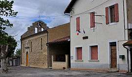 Church and town hall | |
 Besset Location within Occitanie region  Besset | |
| Coordinates: 43°04′45″N 1°50′15″E / 43.0792°N 1.8375°ECoordinates: 43°04′45″N 1°50′15″E / 43.0792°N 1.8375°E | |
| Country | France |
| Region | Occitanie |
| Department | Ariège |
| Arrondissement | Pamiers |
| Canton | Mirepoix |
| Intercommunality | Vallée moyenne de l'Hers |
| Government | |
| • Mayor (2008–2014) | Franco Arnaud |
| Area1 | 8.13 km2 (3.14 sq mi) |
| Population (2008)2 | 144 |
| • Density | 18/km2 (46/sq mi) |
| Time zone | UTC+1 (CET) |
| • Summer (DST) | UTC+2 (CEST) |
| INSEE/Postal code | 09052 /09500 |
| Elevation |
279–480 m (915–1,575 ft) (avg. 290 m or 950 ft) |
|
1 French Land Register data, which excludes lakes, ponds, glaciers > 1 km2 (0.386 sq mi or 247 acres) and river estuaries. 2 Population without double counting: residents of multiple communes (e.g., students and military personnel) only counted once. | |
Besset is a commune in the Ariège department of southwestern France.
Population
Inhabitants of Besset are called Bessetois.
| Historical population | ||
|---|---|---|
| Year | Pop. | ±% |
| 1962 | 64 | — |
| 1968 | 88 | +37.5% |
| 1975 | 98 | +11.4% |
| 1982 | 114 | +16.3% |
| 1990 | 123 | +7.9% |
| 1999 | 119 | −3.3% |
| 2008 | 144 | +21.0% |
See also
References
| Wikimedia Commons has media related to Besset. |
This article is issued from
Wikipedia.
The text is licensed under Creative Commons - Attribution - Sharealike.
Additional terms may apply for the media files.