Loubières
| Loubières | |
|---|---|
| Commune | |
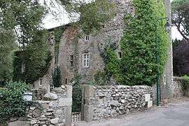 The chateau in Loubières | |
 Loubières Location within Occitanie region  Loubières | |
| Coordinates: 43°00′37″N 1°36′03″E / 43.0103°N 1.6008°ECoordinates: 43°00′37″N 1°36′03″E / 43.0103°N 1.6008°E | |
| Country | France |
| Region | Occitanie |
| Department | Ariège |
| Arrondissement | Foix |
| Canton | Val d'Ariège |
| Intercommunality | Pays de Foix |
| Government | |
| • Mayor (2008–2014) | Didier Calvet |
| Area1 | 2.9 km2 (1.1 sq mi) |
| Population (2008)2 | 207 |
| • Density | 71/km2 (180/sq mi) |
| Time zone | UTC+1 (CET) |
| • Summer (DST) | UTC+2 (CEST) |
| INSEE/Postal code | 09174 /09000 |
| Elevation |
355–569 m (1,165–1,867 ft) (avg. 350 m or 1,150 ft) |
|
1 French Land Register data, which excludes lakes, ponds, glaciers > 1 km2 (0.386 sq mi or 247 acres) and river estuaries. 2 Population without double counting: residents of multiple communes (e.g., students and military personnel) only counted once. | |
Loubières is a commune in the Ariège department in southwestern France.
Population
| Historical population | ||
|---|---|---|
| Year | Pop. | ±% |
| 1962 | 92 | — |
| 1968 | 93 | +1.1% |
| 1975 | 118 | +26.9% |
| 1982 | 158 | +33.9% |
| 1990 | 185 | +17.1% |
| 1999 | 201 | +8.6% |
| 2008 | 207 | +3.0% |
See also
References
| Wikimedia Commons has media related to Loubières. |
This article is issued from
Wikipedia.
The text is licensed under Creative Commons - Attribution - Sharealike.
Additional terms may apply for the media files.