Sabarat
| Sabarat | ||
|---|---|---|
| Commune | ||
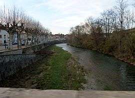 The Arize at Sabarat | ||
| ||
 Sabarat Location within Occitanie region  Sabarat | ||
| Coordinates: 43°06′02″N 1°23′23″E / 43.1006°N 1.3897°ECoordinates: 43°06′02″N 1°23′23″E / 43.1006°N 1.3897°E | ||
| Country | France | |
| Region | Occitanie | |
| Department | Ariège | |
| Arrondissement | Saint-Girons | |
| Canton | Arize-Lèze | |
| Intercommunality | L'Arize | |
| Government | ||
| • Mayor (2008–2014) | Laurent Milhorat | |
| Area1 | 9.5 km2 (3.7 sq mi) | |
| Population (2008)2 | 351 | |
| • Density | 37/km2 (96/sq mi) | |
| Time zone | UTC+1 (CET) | |
| • Summer (DST) | UTC+2 (CEST) | |
| INSEE/Postal code | 09253 /09350 | |
| Elevation |
265–510 m (869–1,673 ft) (avg. 266 m or 873 ft) | |
|
1 French Land Register data, which excludes lakes, ponds, glaciers > 1 km2 (0.386 sq mi or 247 acres) and river estuaries. 2 Population without double counting: residents of multiple communes (e.g., students and military personnel) only counted once. | ||
.svg.png)
Sabarat is a commune in the Ariège department in southwestern France.
Population
Inhabitants are called Sabaratois.
| Historical population | ||
|---|---|---|
| Year | Pop. | ±% |
| 1962 | 306 | — |
| 1968 | 327 | +6.9% |
| 1975 | 305 | −6.7% |
| 1982 | 279 | −8.5% |
| 1990 | 304 | +9.0% |
| 1999 | 284 | −6.6% |
| 2008 | 351 | +23.6% |
See also
References
| Wikimedia Commons has media related to Sabarat. |
This article is issued from
Wikipedia.
The text is licensed under Creative Commons - Attribution - Sharealike.
Additional terms may apply for the media files.