Roquefort-les-Cascades
| Roquefort-les-Cascades | ||
|---|---|---|
| Commune | ||
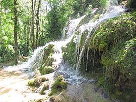 The La Turasse waterfall | ||
| ||
 Roquefort-les-Cascades Location within Occitanie region  Roquefort-les-Cascades | ||
| Coordinates: 42°57′43″N 1°45′24″E / 42.9619°N 1.7567°ECoordinates: 42°57′43″N 1°45′24″E / 42.9619°N 1.7567°E | ||
| Country | France | |
| Region | Occitanie | |
| Department | Ariège | |
| Arrondissement | Pamiers | |
| Canton | Pays d'Olmes | |
| Intercommunality | Pays d'Olmes | |
| Government | ||
| • Mayor (2008–2014) | Dominique Déom | |
| Area1 | 7.08 km2 (2.73 sq mi) | |
| Population (2008)2 | 100 | |
| • Density | 14/km2 (37/sq mi) | |
| Demonym(s) | Roquefortiens | |
| Time zone | UTC+1 (CET) | |
| • Summer (DST) | UTC+2 (CEST) | |
| INSEE/Postal code | 09250 /09300 | |
| Elevation |
433–880 m (1,421–2,887 ft) (avg. 465 m or 1,526 ft) | |
|
1 French Land Register data, which excludes lakes, ponds, glaciers > 1 km2 (0.386 sq mi or 247 acres) and river estuaries. 2 Population without double counting: residents of multiple communes (e.g., students and military personnel) only counted once. | ||

Roquefort-les-Cascades is a commune in the Ariège department in southwestern France.
Population
Inhabitants of Roquefort-les-Cascades are called Roquefortiens.
| Historical population | ||
|---|---|---|
| Year | Pop. | ±% |
| 1962 | 105 | — |
| 1968 | 115 | +9.5% |
| 1975 | 99 | −13.9% |
| 1982 | 105 | +6.1% |
| 1990 | 114 | +8.6% |
| 1999 | 107 | −6.1% |
| 2008 | 100 | −6.5% |
See also
References
| Wikimedia Commons has media related to Roquefort-les-Cascades. |
This article is issued from
Wikipedia.
The text is licensed under Creative Commons - Attribution - Sharealike.
Additional terms may apply for the media files.