Capoulet-et-Junac
| Capoulet-et-Junac | |
|---|---|
| Commune | |
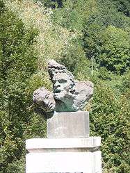 War memorial, sculptor Antoine Bourdelle | |
 Capoulet-et-Junac Location within Occitanie region  Capoulet-et-Junac | |
| Coordinates: 42°47′48″N 1°35′11″E / 42.7967°N 1.5864°ECoordinates: 42°47′48″N 1°35′11″E / 42.7967°N 1.5864°E | |
| Country | France |
| Region | Occitanie |
| Department | Ariège |
| Arrondissement | Foix |
| Canton | Sabarthès |
| Government | |
| • Mayor (2008–2014) | Claude Aynié |
| Area1 | 2.78 km2 (1.07 sq mi) |
| Population (2008)2 | 179 |
| • Density | 64/km2 (170/sq mi) |
| Time zone | UTC+1 (CET) |
| • Summer (DST) | UTC+2 (CEST) |
| INSEE/Postal code | 09077 /09400 |
| Elevation |
559–933 m (1,834–3,061 ft) (avg. 590 m or 1,940 ft) |
|
1 French Land Register data, which excludes lakes, ponds, glaciers > 1 km2 (0.386 sq mi or 247 acres) and river estuaries. 2 Population without double counting: residents of multiple communes (e.g., students and military personnel) only counted once. | |
Capoulet-et-Junac is a commune in the Ariège department in southwestern France.
Population
| Historical population | ||
|---|---|---|
| Year | Pop. | ±% |
| 1962 | 160 | — |
| 1968 | 189 | +18.1% |
| 1975 | 173 | −8.5% |
| 1982 | 158 | −8.7% |
| 1990 | 194 | +22.8% |
| 1999 | 194 | +0.0% |
| 2008 | 179 | −7.7% |
See also
References
| Wikimedia Commons has media related to Capoulet-et-Junac. |
This article is issued from
Wikipedia.
The text is licensed under Creative Commons - Attribution - Sharealike.
Additional terms may apply for the media files.