Ilhat
| Ilhat | ||
|---|---|---|
| Commune | ||
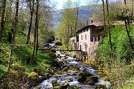 The Douctouyre at Rapy, in Ilhat | ||
| ||
 Ilhat Location within Occitanie region  Ilhat | ||
| Coordinates: 42°57′28″N 1°47′06″E / 42.9578°N 1.785°ECoordinates: 42°57′28″N 1°47′06″E / 42.9578°N 1.785°E | ||
| Country | France | |
| Region | Occitanie | |
| Department | Ariège | |
| Arrondissement | Pamiers | |
| Canton | Pays d'Olmes | |
| Intercommunality | Pays d'Olmes | |
| Government | ||
| • Mayor (2008–2014) | Christian Poplineau | |
| Area1 | 6.89 km2 (2.66 sq mi) | |
| Population (2008)2 | 123 | |
| • Density | 18/km2 (46/sq mi) | |
| Time zone | UTC+1 (CET) | |
| • Summer (DST) | UTC+2 (CEST) | |
| INSEE/Postal code | 09142 /09300 | |
| Elevation |
397–770 m (1,302–2,526 ft) (avg. 434 m or 1,424 ft) | |
|
1 French Land Register data, which excludes lakes, ponds, glaciers > 1 km2 (0.386 sq mi or 247 acres) and river estuaries. 2 Population without double counting: residents of multiple communes (e.g., students and military personnel) only counted once. | ||

Ilhat is a commune in the Ariège department in southwestern France.
Population
| Historical population | ||
|---|---|---|
| Year | Pop. | ±% |
| 1806 | 421 | — |
| 1851 | 435 | +3.3% |
| 1856 | 449 | +3.2% |
| 1901 | 246 | −45.2% |
| 1921 | 176 | −28.5% |
| 1946 | 122 | −30.7% |
| 1962 | 76 | −37.7% |
| 1968 | 89 | +17.1% |
| 1975 | 72 | −19.1% |
| 1982 | 88 | +22.2% |
| 1990 | 97 | +10.2% |
| 1999 | 107 | +10.3% |
| 2008 | 123 | +15.0% |
See also
References
| Wikimedia Commons has media related to Ilhat. |
This article is issued from
Wikipedia.
The text is licensed under Creative Commons - Attribution - Sharealike.
Additional terms may apply for the media files.