Saint-Ybars
| Saint-Ybars | ||
|---|---|---|
| Commune | ||
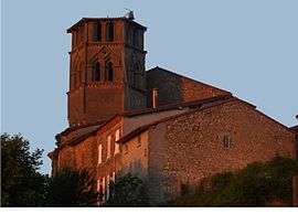 The church in Saint-Ybars | ||
| ||
 Saint-Ybars Location within Occitanie region  Saint-Ybars | ||
| Coordinates: 43°14′19″N 1°23′12″E / 43.2386°N 1.3867°ECoordinates: 43°14′19″N 1°23′12″E / 43.2386°N 1.3867°E | ||
| Country | France | |
| Region | Occitanie | |
| Department | Ariège | |
| Arrondissement | Saint-Girons | |
| Canton | Arize-Lèze | |
| Intercommunality | Vallée de la Lèze | |
| Government | ||
| • Mayor (2008–2014) | Francis Boy | |
| Area1 | 24.31 km2 (9.39 sq mi) | |
| Population (2008)2 | 649 | |
| • Density | 27/km2 (69/sq mi) | |
| Time zone | UTC+1 (CET) | |
| • Summer (DST) | UTC+2 (CEST) | |
| INSEE/Postal code | 09277 /09210 | |
| Elevation |
213–334 m (699–1,096 ft) (avg. 290 m or 950 ft) | |
|
1 French Land Register data, which excludes lakes, ponds, glaciers > 1 km2 (0.386 sq mi or 247 acres) and river estuaries. 2 Population without double counting: residents of multiple communes (e.g., students and military personnel) only counted once. | ||
.svg.png)
Saint-Ybars is a commune in the Ariège department in southwestern France.
Population
Inhabitants of Saint-Ybars are called Eparchois.
| Historical population | ||
|---|---|---|
| Year | Pop. | ±% |
| 1962 | 635 | — |
| 1968 | 654 | +3.0% |
| 1975 | 524 | −19.9% |
| 1982 | 476 | −9.2% |
| 1990 | 512 | +7.6% |
| 1999 | 561 | +9.6% |
| 2008 | 649 | +15.7% |
Geography
The Lèze forms part of the commune's western border.
See also
References
| Wikimedia Commons has media related to Saint-Ybars. |
This article is issued from
Wikipedia.
The text is licensed under Creative Commons - Attribution - Sharealike.
Additional terms may apply for the media files.