Unac
| Unac | |
|---|---|
| Commune | |
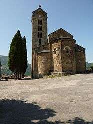 The church in Unac | |
 Unac Location within Occitanie region  Unac | |
| Coordinates: 42°45′43″N 1°46′33″E / 42.7619°N 1.7758°ECoordinates: 42°45′43″N 1°46′33″E / 42.7619°N 1.7758°E | |
| Country | France |
| Region | Occitanie |
| Department | Ariège |
| Arrondissement | Foix |
| Canton | Haute-Ariège |
| Intercommunality | Vallées d'Ax |
| Government | |
| • Mayor (2008–2014) | André Urena |
| Area1 | 2.65 km2 (1.02 sq mi) |
| Population (2008)2 | 122 |
| • Density | 46/km2 (120/sq mi) |
| Time zone | UTC+1 (CET) |
| • Summer (DST) | UTC+2 (CEST) |
| INSEE/Postal code | 09318 /09250 |
| Elevation |
598–1,160 m (1,962–3,806 ft) (avg. 640 m or 2,100 ft) |
|
1 French Land Register data, which excludes lakes, ponds, glaciers > 1 km2 (0.386 sq mi or 247 acres) and river estuaries. 2 Population without double counting: residents of multiple communes (e.g., students and military personnel) only counted once. | |
Unac is a commune in the Ariège department in southwestern France.
Population
| Historical population | ||
|---|---|---|
| Year | Pop. | ±% |
| 1962 | 122 | — |
| 1968 | 146 | +19.7% |
| 1975 | 137 | −6.2% |
| 1982 | 121 | −11.7% |
| 1990 | 118 | −2.5% |
| 1999 | 117 | −0.8% |
| 2008 | 122 | +4.3% |
See also
References
| Wikimedia Commons has media related to Unac. |
This article is issued from
Wikipedia.
The text is licensed under Creative Commons - Attribution - Sharealike.
Additional terms may apply for the media files.