Prades, Ariège
| Prades | ||
|---|---|---|
| Commune | ||
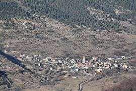 Prades seen from above | ||
| ||
 Prades Location within Occitanie region  Prades | ||
| Coordinates: 42°47′16″N 1°52′45″E / 42.7878°N 1.8792°ECoordinates: 42°47′16″N 1°52′45″E / 42.7878°N 1.8792°E | ||
| Country | France | |
| Region | Occitanie | |
| Department | Ariège | |
| Arrondissement | Foix | |
| Canton | Haute-Ariège | |
| Intercommunality | vallées d'Ax | |
| Government | ||
| • Mayor (2014–2020) | Hervé Peloffi | |
| Area1 | 28.97 km2 (11.19 sq mi) | |
| Population (2008)2 | 50 | |
| • Density | 1.7/km2 (4.5/sq mi) | |
| Time zone | UTC+1 (CET) | |
| • Summer (DST) | UTC+2 (CEST) | |
| INSEE/Postal code | 09232 /09110 | |
| Elevation |
1,078–1,921 m (3,537–6,302 ft) (avg. 1,250 m or 4,100 ft) | |
|
1 French Land Register data, which excludes lakes, ponds, glaciers > 1 km2 (0.386 sq mi or 247 acres) and river estuaries. 2 Population without double counting: residents of multiple communes (e.g., students and military personnel) only counted once. | ||
-1696.svg.png)
Prades is a commune in the Ariège department in southwestern France.
Population
Inhabitants are called Pradéens.
| Historical population | ||
|---|---|---|
| Year | Pop. | ±% |
| 1962 | 88 | — |
| 1968 | 97 | +10.2% |
| 1975 | 73 | −24.7% |
| 1982 | 67 | −8.2% |
| 1990 | 53 | −20.9% |
| 1999 | 47 | −11.3% |
| 2008 | 50 | +6.4% |
Geography
The village is located in the Pyrenees on the River Hers-Vif.
See also
References
| Wikimedia Commons has media related to Prades, Ariège. |
This article is issued from
Wikipedia.
The text is licensed under Creative Commons - Attribution - Sharealike.
Additional terms may apply for the media files.