Pech, Ariège
| Pech | |
|---|---|
| Commune | |
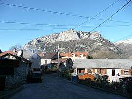 The Montels Quarter in Pech | |
 Pech Location within Occitanie region  Pech | |
| Coordinates: 42°47′02″N 1°41′14″E / 42.7839°N 1.6872°ECoordinates: 42°47′02″N 1°41′14″E / 42.7839°N 1.6872°E | |
| Country | France |
| Region | Occitanie |
| Department | Ariège |
| Arrondissement | Foix |
| Canton | Haute-Ariège |
| Intercommunality | Vallées d'Ax |
| Government | |
| • Mayor (2008–2014) | François Oliveira |
| Area1 | 4.81 km2 (1.86 sq mi) |
| Population (2008)2 | 34 |
| • Density | 7.1/km2 (18/sq mi) |
| Time zone | UTC+1 (CET) |
| • Summer (DST) | UTC+2 (CEST) |
| INSEE/Postal code | 09226 /09310 |
| Elevation |
533–1,729 m (1,749–5,673 ft) (avg. 545 m or 1,788 ft) |
|
1 French Land Register data, which excludes lakes, ponds, glaciers > 1 km2 (0.386 sq mi or 247 acres) and river estuaries. 2 Population without double counting: residents of multiple communes (e.g., students and military personnel) only counted once. | |
Pech is a commune in the Ariège department of southwestern France.
Population
Inhabitants of Pech are called Péchois.
| Historical population | ||
|---|---|---|
| Year | Pop. | ±% |
| 1896 | 120 | — |
| 1962 | 33 | −72.5% |
| 1968 | 48 | +45.5% |
| 1975 | 30 | −37.5% |
| 1982 | 21 | −30.0% |
| 1990 | 27 | +28.6% |
| 1999 | 34 | +25.9% |
| 2008 | 34 | +0.0% |
See also
References
| Wikimedia Commons has media related to Pech. |
This article is issued from
Wikipedia.
The text is licensed under Creative Commons - Attribution - Sharealike.
Additional terms may apply for the media files.