Le Carlaret
| Le Carlaret | |
|---|---|
| Commune | |
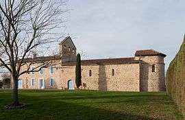 The church in Le Carlaret | |
 Le Carlaret Location within Occitanie region  Le Carlaret | |
| Coordinates: 43°08′30″N 1°41′46″E / 43.1417°N 1.6961°ECoordinates: 43°08′30″N 1°41′46″E / 43.1417°N 1.6961°E | |
| Country | France |
| Region | Occitanie |
| Department | Ariège |
| Arrondissement | Pamiers |
| Canton | Pamiers-2 |
| Intercommunality | Pays de Pamiers |
| Government | |
| • Mayor (2008–2014) | Guy Bouche |
| Area1 | 9.39 km2 (3.63 sq mi) |
| Population (2008)2 | 209 |
| • Density | 22/km2 (58/sq mi) |
| Time zone | UTC+1 (CET) |
| • Summer (DST) | UTC+2 (CEST) |
| INSEE/Postal code | 09081 /09100 |
| Elevation |
250–327 m (820–1,073 ft) (avg. 289 m or 948 ft) |
|
1 French Land Register data, which excludes lakes, ponds, glaciers > 1 km2 (0.386 sq mi or 247 acres) and river estuaries. 2 Population without double counting: residents of multiple communes (e.g., students and military personnel) only counted once. | |
Le Carlaret is a commune in the Ariège department in southwestern France.
Population
Its inhabitants are called Carlaretois.
| Historical population | ||
|---|---|---|
| Year | Pop. | ±% |
| 1962 | 106 | — |
| 1968 | 135 | +27.4% |
| 1975 | 154 | +14.1% |
| 1982 | 149 | −3.2% |
| 1990 | 142 | −4.7% |
| 1999 | 141 | −0.7% |
| 2008 | 209 | +48.2% |
See also
References
| Wikimedia Commons has media related to Le Carlaret. |
This article is issued from
Wikipedia.
The text is licensed under Creative Commons - Attribution - Sharealike.
Additional terms may apply for the media files.