Val-d'Arcomie
| Val-d'Arcomie | |
|---|---|
| Commune | |
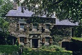 Allègre farm, in the village of Loubaresse | |
 Val-d'Arcomie Location within Auvergne-Rhône-Alpes region  Val-d'Arcomie | |
| Coordinates: 44°56′02″N 3°12′40″E / 44.934°N 3.211°ECoordinates: 44°56′02″N 3°12′40″E / 44.934°N 3.211°E | |
| Country | France |
| Region | Auvergne-Rhône-Alpes |
| Department | Cantal |
| Arrondissement | Saint-Flour |
| Canton | Neuvéglise |
| Area1 | 86.27 km2 (33.31 sq mi) |
| Population (2013)2 | 999 |
| • Density | 12/km2 (30/sq mi) |
| Time zone | UTC+1 (CET) |
| • Summer (DST) | UTC+2 (CEST) |
| INSEE/Postal code | 15108 /15320 |
|
1 French Land Register data, which excludes lakes, ponds, glaciers > 1 km2 (0.386 sq mi or 247 acres) and river estuaries. 2 Population without double counting: residents of multiple communes (e.g., students and military personnel) only counted once. | |
Val-d'Arcomie is a commune in the Cantal department of southern France. The municipality was established on 1 January 2016 and consists of the former communes of Loubaresse, Faverolles, Saint-Just and Saint-Marc.[1]
See also
References
| Wikimedia Commons has media related to Val d'Arcomie. |
- ↑ Arrêté préfectoral 30 September 2015 (in French)
This article is issued from
Wikipedia.
The text is licensed under Creative Commons - Attribution - Sharealike.
Additional terms may apply for the media files.