Clermont, Florida
| Clermont, Florida | |
|---|---|
| City | |
| City of Clermont | |
 | |
| Motto(s): "Choice of Champions" | |
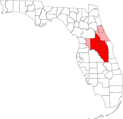
 Location in Lake County and the state of Florida | |
| Coordinates: 28°32′51″N 81°44′58″W / 28.54750°N 81.74944°WCoordinates: 28°32′51″N 81°44′58″W / 28.54750°N 81.74944°W | |
| Country |
|
| State |
|
| County |
|
| Area[1] | |
| • Total | 16.38 sq mi (42.43 km2) |
| • Land | 14.26 sq mi (36.92 km2) |
| • Water | 2.13 sq mi (5.50 km2) |
| Elevation[2] | 307 ft (93 m) |
| Population (2010)[3] | |
| • Total | 28,742 |
| • Estimate (2017)[4] | 35,211 |
| • Density | 2,470.08/sq mi (953.68/km2) |
| Time zone | UTC-5 (Eastern (EST)) |
| • Summer (DST) | UTC-4 (EDT) |
| ZIP codes | 34711-34715 |
| Area code(s) | 352 |
| FIPS code | 12-12925[5] |
| GNIS feature ID | 0280563[6] |
| Website | http://www.clermontfl.gov/ |
Clermont is a city in Lake County, Florida, United States, about 22 miles (35 km) west of Orlando and 22 miles (35 km) southeast of Leesburg. The population was 30,201 in 2013. The city is residential in character and its economy is centered in retail trade, lodging, and tourism-oriented restaurants and bars. It is part of the Orlando–Kissimmee–Sanford Metropolitan Statistical Area.
Clermont is home to the 1956 Florida Citrus Tower, one of Florida's first landmarks.[7]
Geography
Clermont is at 28°32′51″N 81°44′58″W / 28.54750°N 81.74944°W (28.547584, -81.749519).[8]
According to the United States Census Bureau, the city has a total area of 11.5 square miles (30 km2), of which 10.5 square miles (27 km2) is land and 1.0 square mile (2.6 km2) (8.54%) is water.

The Clermont area lies on the northern part of the Lake Wales Ridge. There are rolling hills atypical of the Florida peninsula. Nearby are the Clermont Chain of lakes[9] and Lake Apopka.
Climate
The annual average variations of various measurements are:
Rainfall 36.6 to 51.2 inches (930 to 1,300 mm); Snowfall is zero; 25.2 Precipitation Days 101 to 107; Sunny Days 205 to 236; Avg. July High 86.5 to 91.7 °F (30.3 to 33.2 °C); Avg. Jan. Low 20.8 to 48.8 °F (−6.2 to 9.3 °C); Comfort Index (higher=better) 28 to 44; UV Index from 4.3 to 6.3; Elevation 116 to 307 feet (35 to 94 m).
The town gets 51 inches (1,300 mm) of rain per year, more than the US average of 37 inches (940 mm).
On average, there are 236 sunny days per year. The July high is around 92 °F (33 °C). The January low is 49. The comfort index, which is based on humidity during the hot months, is a 28 out of 100, where higher is more comfortable.
| Climate data for Clermont, Florida (1980-2010) | |||||||||||||
|---|---|---|---|---|---|---|---|---|---|---|---|---|---|
| Month | Jan | Feb | Mar | Apr | May | Jun | Jul | Aug | Sep | Oct | Nov | Dec | Year |
| Average high °F (°C) | 70.1 (21.2) |
73.1 (22.8) |
77.6 (25.3) |
82.3 (27.9) |
88.1 (31.2) |
90.5 (32.5) |
91.5 (33.1) |
91.2 (32.9) |
89.1 (31.7) |
84.1 (28.9) |
77.9 (25.5) |
71.9 (22.2) |
82.3 (27.9) |
| Average low °F (°C) | 46.7 (8.2) |
49.5 (9.7) |
53.6 (12) |
57.9 (14.4) |
64.4 (18) |
70.4 (21.3) |
72.1 (22.3) |
72.3 (22.4) |
70.6 (21.4) |
63.9 (17.7) |
55.9 (13.3) |
49.7 (9.8) |
60.6 (15.9) |
| Average precipitation inches (mm) | 3.0 (76) |
2.8 (71) |
4.1 (104) |
2.5 (64) |
2.9 (74) |
7.6 (193) |
7.4 (188) |
7.8 (198) |
6.1 (155) |
2.7 (69) |
2.1 (53) |
2.6 (66) |
51.6 (1,311) |
| Source: USA.com[10] | |||||||||||||
History
Clermont was founded in 1884 and named for the French birthplace of A.F. Wrotniski, manager of the Clermont Improvement Company, formed for land development.[11] The city was incorporated in 1916. Much of the county was first developed as orange and other citrus groves, which was the basis of the economy through the mid-20th century. For instance, Apshawa Groves owned and worked large expanses of land in the county. It later adapted as a major real estate company. Tourism also became increasingly important.
The appearance of the historic downtown district has not changed much since 1962.
The population grew 207% from 2000 to 2010, with commensurate economic growth, attracting big box retail stores. In spring 2010, the Clermont Landings shopping center opened, featuring 20 shops and restaurants and the city's first cinema. Increased pollution from runoff and residential development has hurt the city's lakes and other natural resources.[12]
Demographics
| Historical population | |||
|---|---|---|---|
| Census | Pop. | %± | |
| 1920 | 496 | — | |
| 1930 | 1,086 | 119.0% | |
| 1940 | 1,631 | 50.2% | |
| 1950 | 2,168 | 32.9% | |
| 1960 | 3,313 | 52.8% | |
| 1970 | 3,661 | 10.5% | |
| 1980 | 5,461 | 49.2% | |
| 1990 | 6,910 | 26.5% | |
| 2000 | 9,333 | 35.1% | |
| 2010 | 28,742 | 208.0% | |
| Est. 2017 | 35,211 | [4] | 22.5% |
| U.S. Decennial Census[13] | |||
As of the census[5] of 2010, there were 28,742 people residing in the city in 11,216 households. The population density in 2000 was 812/mi² (314/km²). There were 12,730 housing units. In 2000 the average density of Clermont 380/mi² (147/km²). The racial makeup of the city was 71.69% White, 14.41% African American, 0.42% Native American, 4.19% Asian, 5.37% from other races, and 3.83% from two or more races. Hispanic or Latino of any race were 17.75% of the population.
21.28% of households had children under the age of 18 living with them, 55.1% were married couples living together, 10.3% had a female householder with no husband present, and 31.5% were non-families. 26.3% of all households were made up of individuals and 12.5% had someone living alone who was 65 years of age or older. The average household size was 2.29 and the average family size was 2.73.
In the city, the population was distributed with 20.1% under the age of 18, 6.3% from 18 to 24, 24.0% from 25 to 44, 24.7% from 45 to 64, and 24.8% who were 65 years of age or older. The median age was 45 years. For every 100 females, there were 89.9 males. For every 100 females age 18 and over, there were 85.5 males.
In 2017, 89.6% of the population identified with a religion. 27.7% were Baptist, 3.1% were Catholic, Methodist 3.6%, Pentecostal 2.4%, Presbyterian 2.1%, Lutheran 1.4%, Other Christian 78.1%, Jews 1%.[14]
The median income for a household in the city was $39,290, and the median income for a family was $48,216. Males had a median income of $36,240 versus $26,571 for females. The per capita income for the city was $21,099. About 6.3% of families and 7.8% of the population were below the poverty line, including 15.0% of those under age 18 and 4.5% of those age 65 or over.
The income per capita is $24,952, which includes all adults and children. The median household income is $45,980.
The median home value in town is $227,510. Home appreciation was -21.40% during 2009. Renters made up 23.21% of the population. 8.33% of houses and apartments were unoccupied (vacancy rate).
Occupations
Population by occupation:
- Management, Business, and Financial Operations 13.68% 13.61%
- Professional and Related Occupations 17.31% 20.24%
- Service 22.30% 14.75%
- Sales and Office 27.17% 26.74%
- Farming, Fishing, and Forestry 0.42% 0.74%
- Construction, Extraction, and Maintenance 8.98% 9.48%
- Production, Transportation, and Material Moving 10.13% 14.44%
The unemployment rate in Clermont was 10.30%, with a job growth of -3.40%.
The Clermont sales tax rate is 7.00%.
Education
Local schools include Minneola Elementary School, South Lake Charter Elementary (also known as Imagine Schools at South Lake), Cypress Ridge Elementary School, Lost Lake Elementary, Clermont Elementary School, Clermont Middle School, Windy Hill Middle School, East Ridge Middle School, Lake Minneola High School, East Ridge High School, South Lake High School, Sawgrass Bay Elementary, Pine Ridge Elementary, Real life Christian Academy, and Grassy Lake Elementary.
Lake-Sumter State College and the University of Central Florida have a joint-use campus in Clermont.
Places
South Lake Hospital is the regional hospital of south Lake County.
The United States Triathlon National Training Center is located in Clermont. Duathlons, Triathlons and cross country races are held at the facility.
Waterfront Park is located along Lake Minneola, The park includes picnic areas, a swimming area, fishing piers and a playground. There are rentals of paddleboards, kayaks and bicycles. A fitness trail that is part of a 30-mile system runs through the park.
Notable people
- Dale Barnstable, retired professional basketball player.
- Kate DiCamillo, author of children's books.[15]
- Ryan Dungey, professional motocross racer.
- Shane Greene, professional baseball player.
- Peter Hooten, actor
- Marvin Musquin (born December 30, 1989 in La Reole, France) is a French professional motocross racer.
- Randy Pedersen, professional bowler on the PBA Tour and bowling announcer.
Transportation
The main roads through Clermont consist of State Road 50 and U.S. Route 27.
Notes
- ↑ "2017 U.S. Gazetteer Files". United States Census Bureau. Retrieved Sep 20, 2018.
- ↑ "USGS Map Name: Clermont East, FL Map MRC: 28081E6 Map Center: N28.55625° W81.71832° Datum: NAD83 Zoom: 4m/pixel". United States Geological Survey.
- ↑ "Population Estimates" (CSV). 2008 Population Estimates. United States Census Bureau. July 1, 2009. Retrieved July 24, 2009.
- 1 2 "Population and Housing Unit Estimates". Retrieved March 24, 2018.
- 1 2 "American FactFinder". United States Census Bureau. Archived from the original on 2013-09-11. Retrieved 2008-01-31.
- ↑ "US Board on Geographic Names". United States Geological Survey. 2007-10-25. Retrieved 2008-01-31.
- ↑ "The Citrus Tower". The Citrus Tower. Retrieved 2012-01-26.
- ↑ "US Gazetteer files: 2010, 2000, and 1990". United States Census Bureau. 2011-02-12. Retrieved 2011-04-23.
- ↑ "Clermont Chain of Lakes – South Lake County's Pride - Outside of Orlando".
- ↑ "Climatological Information for Clermont, Florida", USA.com, 2003. Web: .
- ↑ Morris, Allen (1995). Florida Place Names. p. 52. ISBN 978 1 56164 084 3.
- ↑ "Algae a threat to health of Clermont lakes".
- ↑ "Census of Population and Housing". Census.gov. Archived from the original on May 12, 2015. Retrieved June 4, 2015.
- ↑ "Religion". bestplaces.net. 2011-02-09.
- ↑ Dickinson, Joy Wallace. "'Winn-Dixie' author returns to Florida roots in new tale". OrlandoSentinel.com. Retrieved 2017-02-13.
External links
- Official website
- http://www.city-data.com/city/Clermont-Florida.html
- http://www.cityofclermontfl.com
| Wikimedia Commons has media related to Clermont, Florida. |
Municipalities and communities of Lake County, Florida, United States | ||
|---|---|---|
| Cities |  | |
| Towns | ||
| CDPs | ||
| Unincorporated communities |
| |
| Footnotes | ‡This populated place also has portions in an adjacent county or counties | |