Skyway (Metro Manila)
| |
|---|---|
| Route information | |
| Length |
31.2 km (19.4 mi) including Stage 3 (under construction) |
| Component highways |
|
| Major junctions | |
| North end |
|
| South end |
|
| Location | |
| Major cities | Makati, Pasay, Taguig, Parañaque, Muntinlupa |
| Highway system | |
|
Roads in the Philippines | |
_sign.svg.png)

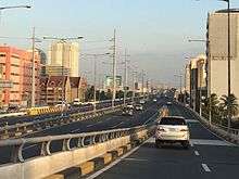
The Skyway, or officially, the Metro Manila Skyway System (MMSWS), is an elevated highway serving as the main expressway in southern Metro Manila, Philippines, following much of the existing South Luzon Expressway (SLEX)'s alignment by going over it. It stretches from Gil Puyat Avenue in the north to Alabang–Zapote Road in the south and crosses through the highly urbanized areas of Makati, Pasay, Taguig, Parañaque, and Muntinlupa, relieving the SLEX and other major thoroughfares from heavy traffic.
The Skyway is the first fully grade-separated highway in the Philippines. It is one of the longest flyovers in the world with a total length of 31.2 kilometres (19.4 mi). The Skyway provides access to the Ninoy Aquino International Airport via the new NAIA Expressway. With the completion of the Skyway Extension Stage 3 scheduled in 2020, the elevated expressway will connect to the North Luzon Expressway in Quezon City and help cut the travel time between Manila and Clark International Airport in Pampanga.[1]
Route description

The Skyway originally begins in Barangay San Isidro, Makati, just south of Gil Puyat Avenue. It rises above the Magallanes Interchange and returns to its original level after crossing EDSA. The first elevated segment ends with the NAIA Expressway interchange, where it descends into ground level because of structural height restrictions from its proximity to the Ninoy Aquino International Airport, paralleling SLEX and the PNR Metro South Commuter Line in the Pasay–Taguig boundary. Skyway returns into an elevated expressway near C-5 Exit and Arca South. It soon slightly curves in Bicutan, near its former terminus, and continuously runs above SLEX. On Sucat Exit, Skyway rises above the eastern terminus of Dr. A. Santos Avenue and descends before approaching the toll plaza in Cupang, Muntinlupa. An exit leads back to the South Luzon Expressway and an entrance ramp carries traffic vice versa. Past the toll plaza and the exit to SLEX, Skyway narrows into one lane per direction, and curves westward before joining Alabang–Zapote Road near South Station in Alabang.
History
With the opening of the Skyway system, motorists are treated to a toll road network as traffic at the South Luzon Expressway considerably improved with the additional roadway capacity, rehabilitated roads, upgraded and newly constructed facilities.
On November 27, 1995, PT CITRA, an investor, entered into a Supplemental Toll Operation Agreement (STOA) with the Republic of the Philippines, through the Toll Regulatory Board (TRB), as grantor, and the Philippine National Construction Corporation (PNCC) as operator. The STOA was the result of negotiations among the parties which officially began on October 31, 1994 with the organization of the Technical Working Group composed of representatives from the Board of Investments (BOI), the Department of Finance (DOF), AIA Capital as financial adviser, the Department of Public Works and Highways (DPWH), the TRB, the PNCC, and the PT CITRA Group.
Under the STOA, CMMTC was mandated to finance, design and construct stage 1 of the South Metro Manila Tollway Project, consisting of both an elevated expressway from Bicutan to Gil Puyat and integrating into it the upgrade and the rehabilitation of the at-grade portion of the South Metro Manila Tollway project, consisting of both an elevated expressway from Nichols to Alabang, are considered as an integrated system of the South Metro Manila Tollway : Stage 1. The STOA was duly approved by the former Philippine President Fidel V. Ramos on April 7, 1996.
In January 1997, TRB and CMMTC, together with the project contractor Hutama RSEA JO. Inc. independent consultants to the TRB Pertconsult International Philippines, consulting engineers Renardet S.A., Inter-Structure System, Inc., Design Science Incorporated, DMJM International USA, and design consultants Pacific Consultants International, in association with J.F. Cancio & Associates, completed a survey for rehabilitation works required on the at-grade portion of the SLEX from Nichols to Alabang. CMMTC has spent $32,746,652.19 in the Skyway Project Phase 1.
Construction began on August 24, 1995. Gil Puyat Avenue (Buendia), Makati, Magallanes Village, Skyway Toll Plazas A and B and Bicutan Exits were first to be completed on December 26, 1997. The Don Bosco Exit began its construction on November 17, 2001 and was completed on January 3, 2002. NAIA Terminal 3 Exit was in construction between September 5, 2004 and 2010.
On February 2007, the Chinese Prime Minister Wen Jiabao together with the PNCC and the Philippine Government approved and signed the extended STOA.
At present, the Skyway System is now being operated by the Skyway Operations and Maintenance Corporation (SOMCo.), which replaced the PNCC Skyway Corporation in its tollway management and other related functions.
On April 2, 2009, Citra Metro Manila Tollways Corp. announced it will start construction on the second stage of the Skyway by the end of the week.[2] By June 2009 the construction of new pilars is going on.
On May 4, 2010, The Skyway Stage 2 is 50% done and Citra Metro Manila Tollways Corp. rotated highest pierhead in Sucat area.
On July 25, 2010, The Skyway Stage 2 is 65% done, DMCI has finished concreting 134 of the required 238 spans, and has started asphalt overlay.
On December 15, 2010, The Bicutan-Sucat portion of Stage 2 finally opened to the public. The Skyway reverted its toll rates back to its 2007 levels last December 22, 2010. By this time, motorists can use this portion for free.
On April 6, 2011, Hillsborough exit ramp, Alabang toll plaza, and South Station Exit were opened to the public. It is toll-free until April 25. And the existing toll plazas in Nichols had stopped collecting transactions instead, the toll plazas in Bicutan, Sucat and Alabang will collect fees. The temporary ramp in Bicutan from/going to SLEX was closed and was replaced by the new ramp in front of Hillsborough. Traffic is still routed back to at-grade portion.
Stage 2 will extend the existing 9.5-kilometer Gil Puyat (Buendia)-Bicutan elevated toll road by about 7 kilometres (4.3 miles), from Bicutan to Alabang. The construction area at the median section of the toll road in Bicutan will be initially extended to Sucat and fenced off with concrete barriers.
Stage 3 is a proposed 14-kilometer project extending from Gil Puyat (Buendia) to Balintawak Cloverleaf, connecting North Luzon Expressway to South Luzon Expressway via Osmena Highway, Quirino Avenue, Paco-Sta Mesa Road, Old Sta Mesa Road, N. Domingo Street, G. Araneta Avenue, Sgt. Rivera Avenue and A. Bonifacio Avenue.
On February 17, 2014, Citra Metro Manila Tollways Corp. announced that the construction of Skyway Stage 3 will start on Monday at Osmeña Highway and full blast in April 2014.
Skyway's new toll rates were implemented on April 26, 2011. Since 2011, the Metro Manila Skyway was used as a main running course of the Condura Skyway Marathon.[3]
Operations
The rehabilitated at-grade portion of the South Luzon Expressway (SLEX) from Nichols to Alabang and the elevated Expressway from Buendia to Bicutan is now being called the Metro Manila Skyway System. It is operated by the Skyway Operations and Maintenance Corporation (SOMCo), a company of the existing PNCC – concession holder, Citra Metro Manila Tollways Corporation. SOMCo took over the operations and maintenance of the Skyway from the former operator, PNCC Skyway Corporation, effective January 2008 and was established in compliance to the provision stipulated in the July 2007 Amended Supplemental Toll Operators Agreement (A-STOA) between the PNCC, Citra Metro Manila Tollways Corp. and the Toll Regulatory Board (TRB), which gave the management of the 35-kilometer toll road to Citra.
Starting 2008, SOMCo is in charge of the three major operational functions, mainly: the traffic safety and security, the maintenance of facilities, and the toll collection.
Expansion and maintenance
Stage 1
Stage 1 involves the rehabilitation of the Magallanes-Alabang at-grade portion and the construction of a 6-lane, 10-kilometer elevated expressway from Gil Puyat (Buendia) to Bicutan. Stage 1 started on April 7, 1995 and was completed and opened in October 1999.
Stage 2
Stage 2 involves the construction of a 7-kilometer elevated expressway from Bicutan to Alabang's South Station, which began in the 2nd quarter of 2009 and was completed in April 2011. The Bicutan to Sucat segment opened on December 15, 2010, while the new Alabang toll plaza, and the Hillsborough and Alabang South Station exit ramps opened on April 6, 2011.
Stage 3
Due to heavy traffic in Metro Manila, the government proposed to build Skyway Stage 3, passing through some cities in the metropolis, with a length of 14.8 km. This will connect the North and South Luzon Expressways. Construction started on February 17, 2014, and it is expected to be completed by April 2018.[4][5] But due to right of way issues the project may finish in 2020.[6][7]
According to Department of Public Works and Highways Secretary Mark Villar and Department of Transportation Secretary Arthur Tugade, the Buendia-Quirino portion of Skyway stage 3 will be open to motorists in June 2018.
Technical specifications
- Name: Metro Manila Skyway
- Concession Holder: Citra Metro Manila Tollways Corporation
- Operator: Skyway Operations and Maintenance Corporation (SOMCo.)
- Length: 17 kilometres (11 miles)
- Concession starting date: August 24, 1995 (it will start after the rehabilitation, modernization, and extension of the Alabang-Santo Tomas segment)
- Concession ending date: 2010
- Highway exits: 10
- Exit ramps: 3
- Toll plazas: 2
- Height: 11 metres or 36 feet (San Martin De Porres-Bicutan, Don Bosco-Gil Puyat, Makati CBD Exit and Hillsborough-Alabang), 43 metres or 141 feet (Bicutan-Toll A, and Sales-Don Bosco), normal (Toll A-B), 19 metres or 62 feet (Bicutan Exit, Sucat)
Future
Skyway Stage 3 will extend the Skyway northwards and link the missing segment from Gil Puyat (Buendia) to Mindanao Avenue and Balintawak. It will be connected to North Luzon Expressway. This stage is currently under construction. Currently, the government has accepted two different proposals wherein one is from Metro Pacific Tollways Development Corp. (MPTDC which is a subsidiary of Metro Pacific Tollways Corp. (MPTC), that runs NLEX and SCTEX, to build the 13.24-kilometer road which mostly of its right-of-way is via the Street of the C-2 Road & Juan Luna connecting Skyway from NLEX via Mindanao Avenue dubbed as the "NLEX-SLEX Connector Road" while the other is from Citra Metro Manila Tollways Corporation (CMMTC), which runs the Skyway and STAR Tollway, to build the original Skyway Stage 3 from Skyway Buendia to NLEx Balintawak which will run through several major thoroughfares along Metro Manila namely Quirino Avenue, Lacson Avenue, Magsaysay Boulevard, G. Araneta/Sgt. Rivera Avenue, and A. Bonifacio Avenue.
CMMTC Proposal/Skyway Stage 3
Dubbed as the "Skyway Stage 3", the Department of Public Works and Highways (DPWH) had received an unsolicited proposal for the construction of the elevated toll road Skyway’s extension from San Miguel Corp. backed Citra Metro Manila Tollways Corp. (CMMTC) which according to their proposal will run from Bicutan, Taguig to Balintawak, Quezon City.
The DPWH plans to include the project in its PPP thrust and plans to subject the proposal to a Swiss Challenge, Public Works Undersecretary Romeo S. Momo said in a telephone interview on Friday. A Swiss challenge requires a government agency which has received an unsolicited bid for a project to publish the bid and invite third parties to match or exceed it.
MPTDC Proposal/NLEX-SLEX Connector Road
Meanwhile, a year before the CMMTC proposal was unveiled NLEX concessionaire subsidiary Metro Pacific Tollway Development Corporation (MPTDC) through its Manila North Tollways Corporation (MNTC) submitted their proposal which is dubbed as "Segment 11 or the NLEx-SLEx Connector Road" in the NLEx Phase 2 project which involves the construction of a 13.24 kilometer Elevated Expressway from Buendia (Skyway Stage 1) to the C-3 Road which will connect to the NLEx via Segment 10 of the NLEx Phase 2 project in which most of the elevated roadway will be located above the C-2 Road Right-Of-Way.
According to DPWH Secretary Rogelio Singson the MPIC Proposal would likely be pushed through along with the CMMTC proposal as the proposals can co-exist as the projects service two different corridors of the metro.[8]
Tolls
(2017-05-25).jpg)
The Skyway employs a combination of open road, closed road, and barrier toll systems. Northbound toll collection is done at toll barriers at Muntinlupa, where vehicles from the South Luzon Expressway (SLEX) are paid a toll based on their entry point at SLEX, and exits have no toll collection at all. Southbound toll collection is done at the toll barriers upon exit, but for those exiting to SLEX, the toll collection is done on its exits instead. No tickets are issued on entry points on the Skyway.
The Skyway also employs electronic toll collection (ETC) using the Autosweep RFID, and the ETC system previously used E-Pass, which used transponder technology. The ETC systems are also used on the South Luzon Expressway and NAIA Expressway. ETC collection lanes are usually on the leftmost lane of a toll plaza, but may occur on mixed lanes, where cash payments can be done alongside ETC.
As of April 2011, the toll rates (both cash and ETC), from Ayala Greenfield toll plaza, the first toll barrier at South Luzon Expressway northbound, are as follows:
| Class | Amount | ||
|---|---|---|---|
| to & from Alabang/SLEX | to & from Sucat/Dr. A. Santos Ave. | to & from Bicutan/Doña Soledad | |
| Class 1 (Cars, Motorcycles, SUVs) |
₱164.00 | ₱118.00 | ₱72.00 |
| Class 2 (Buses, Light Trucks) |
₱329.00 | ₱237.00 | ₱145.00 |
| Class 3 (Heavy Trucks) |
₱493.00 | ₱356.00 | ₱218.00 |
Exits
Kilometer count are measured from Kilometer Zero in Rizal Park.
Current and Former Exits
| Province | City/Municipality | km | mi | Exit | Name | Destinations | Notes | |
|---|---|---|---|---|---|---|---|---|
| Makati | 6 | 3.7 | Buendia | Buendia | Northbound exit and southbound entrance. North end of expressway. | |||
| 7 | 4.3 | Amorsolo | Amorsolo | Northbound exit and southbound entrance. | ||||
| 7 | 4.3 | Don Bosco | Don Bosco Street | Northbound exit and southbound entrance. Access to Don Bosco Technical Institute. | ||||
| 9 | 5.6 | Magallanes | Magallanes | Northbound exit and southbound entrance. North end of AH26 concurrency. | ||||
| Taguig | 9 | 5.6 | NAIA | Sales Interchange | ||||
| 11 | 6.8 | Skyway Nichols toll plaza A (1997-2011 demolished. 2017-January 26, 2018 Northbound only. Autosweep RFID only) | ||||||
| 11 | 6.8 | Skyway Nichols toll plaza B (1997-2011 demolished. 2017-January 26, 2018 Cash payment only) | ||||||
| Parañaque | 14 | 8.7 | Doña Soledad | Bicutan, Doña Soledad | Southbound exit and northbound entrance. | |||
| 16 | 9.9 | San Martin de Porres (demolished) | SLEX | Temporary southbound exit and northbound entry ramps prior to Stage 2. | ||||
| Muntinlupa | 19 | 12 | Dr. A. Santos | Sucat, Dr. A. Santos | Southbound exit and northbound entrance. | |||
| 20 | 12 | Alabang toll plaza A (Northbound and Southbound. Autosweep RFID and cash payment for Northbound, Pass-thru for Southbound) | ||||||
| 20 | 12 | Alabang toll plaza B (Northbound only. Autosweep RFID and cash payment) | ||||||
| 20 | 12 | Southbound exit and northbound entrance. South end of AH26 concurrency | ||||||
| 21 | 13 | South Station toll plaza (Autosweep RFID and cash payment) | ||||||
| 22 | 14 | South Station | Filinvest City, Alabang | Southbound exit and northbound entrance. South end of expressway. | ||||
1.000 mi = 1.609 km; 1.000 km = 0.621 mi
| ||||||||
Stage 3
| Province | City/Municipality | km | mi | Exit | Name | Destinations | Notes |
|---|---|---|---|---|---|---|---|
| Quezon City | Balintawak | Northern terminus. Continues northward as North Luzon Expressway (NLEX). | |||||
| Caloocan | 5th Avenue | ||||||
| Quezon City | Del Monte toll plaza | ||||||
| Quezon Avenue | |||||||
| E. Rodriguez Sr. | |||||||
| Aurora Boulevard | |||||||
| Manila | NLEX-SLEX Connector | Connection with proposed NLEX-SLEX Connector, connecting with NLEX Harbor Link | |||||
| Nagtahan | |||||||
| Plaza Dilao | |||||||
| Quirino Avenue | |||||||
| Makati | Buendia toll plaza | ||||||
| Buendia | |||||||
1.000 mi = 1.609 km; 1.000 km = 0.621 mi
| |||||||
See also
References
- ↑ Hilario, E. (22 August 2016). "This road project will help solve Metro traffic". Business Mirror. Retrieved 14 January 2017.
- ↑ Skyway Stage 2 Start Construction
- ↑ "Condura Run: Through The Years". Condura. Retrieved 11 January 2016.
- ↑ "NAIA Expressway, Skyway 3, LRT 2 to be delayed; traffic to worsen–MMDA". September 14, 2015. Retrieved November 2, 2015.
- ↑ "METRO MANILA SKYWAY STAGE 3 (MMSS-3) As of March 25, 2015". March 25, 2015. Retrieved April 29, 2015.
- ↑ "NAIA Expressway finally opening on September 22". ABS-CBN. Retrieved 2016-09-07.
- ↑ "New Metro expressway eyed". Inquired. August 7, 2017.
- ↑ Skyway Stage 3/ NLEx-SLEx Connector Road Projects being finalized Archived 2015-06-05 at the Wayback Machine.
External links
| Wikimedia Commons has media related to Metro Manila Skyway. |
| Operational | |
|---|---|
| Planned |
|
| Under construction | |
See also: Philippine expressway network | |
Coordinates: 14°30′23″N 121°2′7″E / 14.50639°N 121.03528°E